
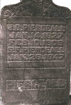
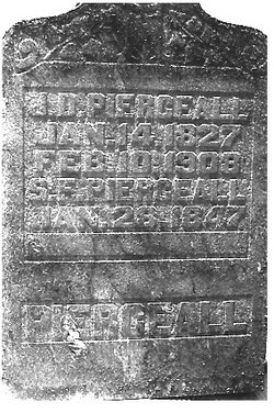
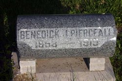
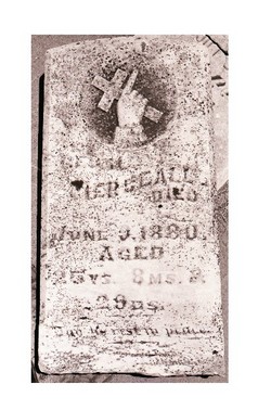
John David Pierceall
| Birth | : | 17 Jan 1827 |
| Death | : | 10 Feb 1908 |
| Burial | : | Lösens kyrka, Lyckeby, Karlskrona kommun, Sweden |
| Coordinate | : | 56.1965965, 15.6882357 |
| Description | : | John was the son of Joseph Madison Pierceall & Elizabeth Abell. He married Delphina Wimsatt on 10 April 1850 & they had 4 children. He married Susan Frances Yager on 3 June 1866 & they had 6 children. John fought for the Union in the Civil War. - from Lillie Riney |
frequently asked questions (FAQ):
-
Where is John David Pierceall's memorial?
John David Pierceall's memorial is located at: Lösens kyrka, Lyckeby, Karlskrona kommun, Sweden.
-
When did John David Pierceall death?
John David Pierceall death on 10 Feb 1908 in
-
Where are the coordinates of the John David Pierceall's memorial?
Latitude: 56.1965965
Longitude: 15.6882357
Family Members:
Parent
Spouse
Siblings

Children

Flowers:


Nearby Cemetories:
1. Lösens kyrka
Lyckeby, Karlskrona kommun, Sweden
Coordinate: 56.1965965, 15.6882357
2. Wämö
Karlskrona, Karlskrona kommun, Sweden
Coordinate: 56.1804250, 15.6017650
3. Jämjö kyrkogård
Jamjo, Karlskrona kommun, Sweden
Coordinate: 56.1921200, 15.8318400
4. Sturkö Kyrkogård
Sturko, Karlskrona kommun, Sweden
Coordinate: 56.0886899, 15.6963390
5. Fridlevstads Kyrkogård
Fridlevstad, Karlskrona kommun, Sweden
Coordinate: 56.2696868, 15.5388697
6. Aspö kyrkogård
Aspo, Karlskrona kommun, Sweden
Coordinate: 56.1135337, 15.5192664
7. Torhamns kyrkogård
Torhamn, Karlskrona kommun, Sweden
Coordinate: 56.0952220, 15.8329000
8. Listerby Cemetery
Listerby, Ronneby kommun, Sweden
Coordinate: 56.1953366, 15.4065383
9. Hjortsberga kyrkogård
Johannishus, Ronneby kommun, Sweden
Coordinate: 56.2255649, 15.4078853
10. Tvings Kyrkogård
Tving, Karlskrona kommun, Sweden
Coordinate: 56.3092001, 15.4655756
11. Gullabo kyrkogård
Gullabo, Torsås kommun, Sweden
Coordinate: 56.4636883, 15.8071821
12. Sophia Magdalena
Soderakra, Torsås kommun, Sweden
Coordinate: 56.4457031, 16.0717222
13. Aaryd Kyrkogård
Aryd, Karlshamns kommun, Sweden
Coordinate: 56.2073510, 15.0095260
14. Karlslunda churchyard
Paryd, Kalmar kommun, Sweden
Coordinate: 56.5685926, 15.9182519
15. Långasjö kyrkogård
Langasjo, Emmaboda kommun, Sweden
Coordinate: 56.5789481, 15.4445904
16. Hällaryd Kyrkogård
Hallaryd, Karlshamns kommun, Sweden
Coordinate: 56.2062400, 14.9474500
17. Södra Sandsjö Kyrkogård
Tingsryds kommun, Sweden
Coordinate: 56.5142500, 15.1544400
18. Arby kyrka
Arby, Hjo kommun, Sweden
Coordinate: 56.5666670, 16.1227780
19. Hvilans Kyrkogård
Karlshamn, Karlshamns kommun, Sweden
Coordinate: 56.1801190, 14.8573860
20. Asarum Kyrkogård
Asarum, Karlshamns kommun, Sweden
Coordinate: 56.2054400, 14.8328400
21. Kastlösa Kyrkogård
Kastlosa, Mörbylånga kommun, Sweden
Coordinate: 56.4585433, 16.4293813
22. Mörbylånga Kyrkogård
Mörbylånga, Mörbylånga kommun, Sweden
Coordinate: 56.5197335, 16.3979088
23. Ljungby cemetery
Ljungbyholm, Kalmar kommun, Sweden
Coordinate: 56.6325710, 16.1683770
24. Sankt Sigfrids kyrkogård
Sankt Sigfrid, Nybro kommun, Sweden
Coordinate: 56.6944100, 15.9999200