

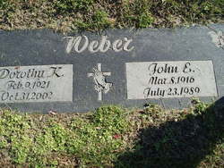
John Edward Weber
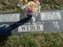
| Birth | : | 8 Mar 1916 Platte County, Nebraska, USA |
| Death | : | 23 Jul 1989 Columbus, Platte County, Nebraska, USA |
| Burial | : | Desert Lawn Memorial Park, Kennewick, Benton County, USA |
| Coordinate | : | 46.1983643, -119.1785507 |
| Description | : | John E. Weber, 73, of Monroe, died Sunday, July 23, 1989, Columbus Community Hospital. Funeral services are 10 a.m. Wednesday at the United Methodist Church in Monroe with Rev. Nancy McMurtry officiating. Burial will be in Roselawn Memorail Cemetery in Columbus. Visitation will be 2 to 9 p.m. Tuesday at McKown Funeral home in Columbus and from 9 to 10 a.m. Wednesday at the church. Mr. Weber was born March 8, 1916, in Platte County, north of Monroe, the son of John F. and Hattie (Schroeder) Weber. He attended Wattsville School and married Dorothy K. Hughes Oct. 12,... Read More |
frequently asked questions (FAQ):
-
Where is John Edward Weber's memorial?
John Edward Weber's memorial is located at: Desert Lawn Memorial Park, Kennewick, Benton County, USA.
-
When did John Edward Weber death?
John Edward Weber death on 23 Jul 1989 in Columbus, Platte County, Nebraska, USA
-
Where are the coordinates of the John Edward Weber's memorial?
Latitude: 46.1983643
Longitude: -119.1785507
Family Members:
Parent
Spouse
Siblings

Children
Flowers:


Nearby Cemetories:
1. Desert Lawn Memorial Park
Kennewick, Benton County, USA
Coordinate: 46.1983643, -119.1785507
2. Saint Paul's Episcopal Church Columbarium
Kennewick, Benton County, USA
Coordinate: 46.1978264, -119.1408081
3. Riverview Heights Cemetery
Kennewick, Benton County, USA
Coordinate: 46.1977768, -119.1400986
4. Saint Joseph Catholic Church Columbarium
Kennewick, Benton County, USA
Coordinate: 46.2041750, -119.1281330
5. Columbia Memorial Gardens
Pasco, Franklin County, USA
Coordinate: 46.2294006, -119.1216965
6. City View Cemetery
Pasco, Franklin County, USA
Coordinate: 46.2496986, -119.0852966
7. Resthaven Cemetery
Richland, Benton County, USA
Coordinate: 46.2861023, -119.2804413
8. All Saints Episcopal Church Memorial Garden
Richland, Benton County, USA
Coordinate: 46.2875000, -119.2824000
9. Sunset Memorial Gardens
Richland, Benton County, USA
Coordinate: 46.2825127, -119.3098602
10. Burbank Cemetery
Walla Walla County, USA
Coordinate: 46.1975365, -118.9809036
11. Country Christian Center Cemetery
Pasco, Franklin County, USA
Coordinate: 46.3873600, -119.1831800
12. Horse Heaven Hills Cemetery
Benton County, USA
Coordinate: 46.1551018, -119.4826736
13. Old German Baptist Brethren Church Cemetery
Pasco, Franklin County, USA
Coordinate: 46.4156800, -119.1566600
14. Wallula Cemetery
Wallula, Walla Walla County, USA
Coordinate: 46.0844400, -118.8997200
15. Evergreen Cemetery
Benton City, Benton County, USA
Coordinate: 46.2867012, -119.4938965
16. Eltopia Cemetery
Eltopia, Franklin County, USA
Coordinate: 46.4608002, -119.0222015
17. Pioneer Memorial Cemetery
Umatilla, Umatilla County, USA
Coordinate: 45.9164009, -119.3486023
18. Sunset Hills Cemetery
Umatilla, Umatilla County, USA
Coordinate: 45.9077988, -119.3507996
19. Holdman Cemetery
Holdman, Umatilla County, USA
Coordinate: 45.8744011, -118.9443970
20. Desert Lawn Memorial Cemetery
Irrigon, Morrow County, USA
Coordinate: 45.8972015, -119.4721985
21. Paterson Memorial Cemetery
Paterson, Benton County, USA
Coordinate: 45.9437943, -119.5705566
22. Stanfield Hutterite Cemetery
Stanfield, Umatilla County, USA
Coordinate: 45.8271307, -119.0798728
23. Country View Cemetery
Basin City, Franklin County, USA
Coordinate: 46.5768210, -119.1484080
24. Hermiston Cemetery
Hermiston, Umatilla County, USA
Coordinate: 45.8236008, -119.2806015