
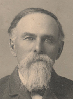


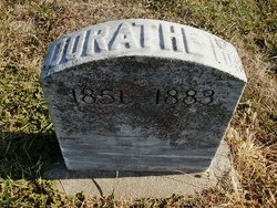
John Frederick Kerl
| Birth | : | 3 Aug 1847 New York, New York County (Manhattan), New York, USA |
| Death | : | 18 May 1930 Nemaha Township, Nemaha County, Kansas, USA |
| Burial | : | Oakwood Cemetery, Red Wing, Goodhue County, USA |
| Coordinate | : | 44.5544250, -92.5223270 |
| Inscription | : | FATHER 66 VOL. I.A. INF. CO. C 6 VOL. P.A. HV. ART. CO. I |
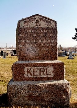
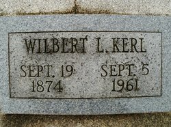
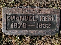
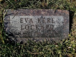
| Description | : | Son of John Louis C. & Martha Hellen C. D. Ketchem Kerl. Married to Agnes Hebberlin in 1873 at Harmony, PA. Remarried to Mary Engaline Meier Mar. 25, 1877 per contributor Luella Hinrichsen. |
frequently asked questions (FAQ):
-
Where is John Frederick Kerl's memorial?
John Frederick Kerl's memorial is located at: Oakwood Cemetery, Red Wing, Goodhue County, USA.
-
When did John Frederick Kerl death?
John Frederick Kerl death on 18 May 1930 in Nemaha Township, Nemaha County, Kansas, USA
-
Where are the coordinates of the John Frederick Kerl's memorial?
Latitude: 44.5544250
Longitude: -92.5223270
Family Members:
Parent

Spouse
Siblings

Children
Flowers:


Nearby Cemetories:
1. Oakwood Cemetery
Red Wing, Goodhue County, USA
Coordinate: 44.5544250, -92.5223270
2. Calvary Cemetery
Red Wing, Goodhue County, USA
Coordinate: 44.5430984, -92.5211029
3. Saint Johns Cemetery
Red Wing, Goodhue County, USA
Coordinate: 44.5657997, -92.5697021
4. Trenton Cemetery
Trenton, Pierce County, USA
Coordinate: 44.5917015, -92.5447006
5. Scherf Cemetery
Wacouta, Goodhue County, USA
Coordinate: 44.5111084, -92.4777832
6. Poor Farm Cemetery
Red Wing, Goodhue County, USA
Coordinate: 44.5750008, -92.5930634
7. Bay City Cemetery
Bay City, Pierce County, USA
Coordinate: 44.5877800, -92.4555588
8. Immanuel Lutheran Church Cemetery
Hay Creek, Goodhue County, USA
Coordinate: 44.4913902, -92.5363922
9. Hay Creek German Methodist Cemetery
Goodhue County, USA
Coordinate: 44.4917908, -92.5437469
10. Wacouta Cemetery
Wacouta, Goodhue County, USA
Coordinate: 44.5477791, -92.4291687
11. Burnside Cemetery
Red Wing, Goodhue County, USA
Coordinate: 44.5677986, -92.6168976
12. Christiansen Dairy Farm Cemetery
Hager City, Pierce County, USA
Coordinate: 44.6225610, -92.5574390
13. Svea Lutheran Cemetery
Trenton, Pierce County, USA
Coordinate: 44.6341362, -92.5168533
14. Old Wells Creek Cemetery
Goodhue County, USA
Coordinate: 44.4846992, -92.4431000
15. Messiah Episcopal Cemetery
Harliss, Goodhue County, USA
Coordinate: 44.5427818, -92.6483307
16. Darrington Cemetery
Hartland, Pierce County, USA
Coordinate: 44.6283500, -92.4357000
17. Mount Tabor Cemetery
Oakridge, Pierce County, USA
Coordinate: 44.5868988, -92.3949966
18. Eidsvold Lutheran Cemetery
Esdaile, Pierce County, USA
Coordinate: 44.6308400, -92.4381700
19. Mount Carmel Cemetery
Goodhue County, USA
Coordinate: 44.5966988, -92.6613998
20. Belvidere Union Cemetery
Belvidere Mills, Goodhue County, USA
Coordinate: 44.4486008, -92.4916992
21. Hope Cemetery
Red Wing, Goodhue County, USA
Coordinate: 44.4831009, -92.6367035
22. Diamond Bluff Cemetery
Diamond Bluff, Pierce County, USA
Coordinate: 44.6417007, -92.6153030
23. Hartland Presbyterian Cemetery
Ellsworth, Pierce County, USA
Coordinate: 44.6604729, -92.4793015
24. Hartland Methodist Cemetery
Esdaile, Pierce County, USA
Coordinate: 44.6227455, -92.3962936