
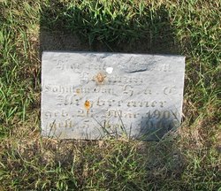
| Birth | : | 4 Sep 1906 Bremer County, Iowa, USA |
| Death | : | 6 Nov 1974 Omaha, Douglas County, Nebraska, USA |
| Burial | : | Luckow Cemetery, Auburn, Sac County, USA |
| Coordinate | : | 42.2168999, -94.9266968 |
| Description | : | John was the son of Henry Aschbrenner and Emma Henning. He married Frieda Rogers on 12 Sep 1927 in Waverly, Bremer, Iowa. He married 2nd Frieda Mohr. Nov 8, 1974 - Carroll Daily Times - John H. Aschbrenner, 68, of Breda died Wednesday, Nov. 6 in Omaha, Neb. Services will be held at 2 p.m. Saturday in St. Peter's Lutheran Church, Coon Valley, near Breda. The Rev. Theodore Letzring will officiate and burial will be in Luckow Cemetery, also near Breda. The Farber and Otteman Funeral Home of Lake View is in charge of arrangements. Pallbearers will be Terry... Read More |
frequently asked questions (FAQ):
-
Where is John H Aschbrenner's memorial?
John H Aschbrenner's memorial is located at: Luckow Cemetery, Auburn, Sac County, USA.
-
When did John H Aschbrenner death?
John H Aschbrenner death on 6 Nov 1974 in Omaha, Douglas County, Nebraska, USA
-
Where are the coordinates of the John H Aschbrenner's memorial?
Latitude: 42.2168999
Longitude: -94.9266968
Family Members:
Parent
Spouse

Siblings
Children
Flowers:


Nearby Cemetories:
1. Luckow Cemetery
Auburn, Sac County, USA
Coordinate: 42.2168999, -94.9266968
2. Saint Bernards Cemetery
Breda, Carroll County, USA
Coordinate: 42.1786003, -94.9732971
3. Oak Lawn Cemetery
Auburn, Sac County, USA
Coordinate: 42.2611008, -94.8852997
4. Saint Marys Cemetery
Sac County, USA
Coordinate: 42.2611008, -94.8839035
5. Grant City Cemetery
Grant City, Sac County, USA
Coordinate: 42.2681007, -94.8908005
6. Our Lady Of Mount Carmel Cemetery
Mount Carmel, Carroll County, USA
Coordinate: 42.1547012, -94.9088974
7. Immanuel Presbyterian Cemetery
Carnarvon, Sac County, USA
Coordinate: 42.2392006, -95.0224991
8. Cottonwood Cemetery
Lake City, Calhoun County, USA
Coordinate: 42.2491989, -94.7936020
9. Wheatland Cemetery
Carroll County, USA
Coordinate: 42.1814003, -95.0582962
10. Ferguson Cemetery
Lake View, Sac County, USA
Coordinate: 42.3142014, -95.0132980
11. Saint Francis Cemetery
Maple River, Carroll County, USA
Coordinate: 42.0969009, -94.9372025
12. Immanuel Cemetery
Lidderdale, Carroll County, USA
Coordinate: 42.1389008, -94.8022003
13. South Wall Lake Cemetery
Wall Lake, Sac County, USA
Coordinate: 42.2318993, -95.0911026
14. Wall Lake Cemetery
Wall Lake, Sac County, USA
Coordinate: 42.2757988, -95.0805969
15. Arcadia Cemetery
Arcadia Township, Carroll County, USA
Coordinate: 42.1000680, -95.0130550
16. East Liberty Cemetery
Lidderdale, Carroll County, USA
Coordinate: 42.1591988, -94.7636032
17. Lake City Cemetery
Lake City, Calhoun County, USA
Coordinate: 42.2719002, -94.7574997
18. Saint Marys Catholic Cemetery
Lake City, Calhoun County, USA
Coordinate: 42.2730000, -94.7567000
19. Saint Peters Lutheran Cemetery
Sac County, USA
Coordinate: 42.3543000, -94.8868000
20. Holy Family Cemetery
Lidderdale, Carroll County, USA
Coordinate: 42.1178017, -94.7839966
21. Saint Johns Catholic Cemetery
Arcadia, Carroll County, USA
Coordinate: 42.0855406, -95.0341577
22. Lanesboro Cemetery
Lanesboro, Carroll County, USA
Coordinate: 42.1810989, -94.7230988
23. Lutheran Emanuel Cemetery
Coon Valley Township, Sac County, USA
Coordinate: 42.3692017, -94.8771973
24. Carroll City Cemetery
Carroll, Carroll County, USA
Coordinate: 42.0560963, -94.8599856