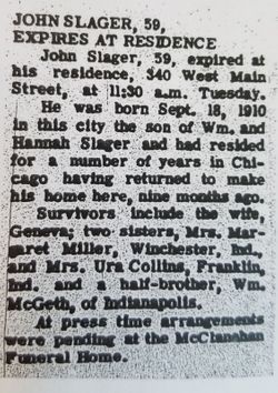
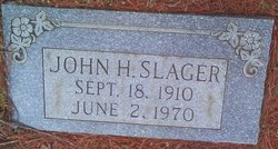
John H Slager
| Birth | : | 18 Sep 1910 Indiana, USA |
| Death | : | 2 Jun 1970 Greene County, Indiana, USA |
| Burial | : | Gowrie Township Cemetery, Gowrie, Webster County, USA |
| Coordinate | : | 42.2813988, -94.3043976 |
frequently asked questions (FAQ):
-
Where is John H Slager's memorial?
John H Slager's memorial is located at: Gowrie Township Cemetery, Gowrie, Webster County, USA.
-
When did John H Slager death?
John H Slager death on 2 Jun 1970 in Greene County, Indiana, USA
-
Where are the coordinates of the John H Slager's memorial?
Latitude: 42.2813988
Longitude: -94.3043976
Family Members:
Parent
Spouse
Siblings
Flowers:
Nearby Cemetories:
1. Gowrie Township Cemetery
Gowrie, Webster County, USA
Coordinate: 42.2813988, -94.3043976
2. Lost Grove Cemetery
Harcourt, Webster County, USA
Coordinate: 42.2583008, -94.2331009
3. Our Saviour Cemetery
Callender, Webster County, USA
Coordinate: 42.3396988, -94.3153000
4. Vinje Cemetery
Callender, Webster County, USA
Coordinate: 42.3693237, -94.2797775
5. Saron Lutheran Cemetery
Callender, Webster County, USA
Coordinate: 42.3690720, -94.2780609
6. Callender Cemetery
Callender, Webster County, USA
Coordinate: 42.3693237, -94.2793427
7. Reading Cemetery
Farnhamville, Calhoun County, USA
Coordinate: 42.2593994, -94.4325027
8. Roland Township Cemetery
Slifer, Webster County, USA
Coordinate: 42.3685989, -94.3685989
9. Mizpah Cemetery
Webster County, USA
Coordinate: 42.3835983, -94.3707962
10. Dawson Cemetery
Paton, Greene County, USA
Coordinate: 42.1655998, -94.3283005
11. Paton Cemetery
Paton, Greene County, USA
Coordinate: 42.1624985, -94.2433014
12. Cedar Cemetery
Rinard, Calhoun County, USA
Coordinate: 42.3456001, -94.4644012
13. Fulton Township Cemetery
Moorland, Webster County, USA
Coordinate: 42.4272000, -94.3159000
14. Fulton Lutheran Cemetery
Roelyn, Webster County, USA
Coordinate: 42.4263992, -94.3688965
15. Elkhorn Township Cemetery
Fort Dodge, Webster County, USA
Coordinate: 42.4276120, -94.2329690
16. Saint Joseph Cemetery
Lohrville, Calhoun County, USA
Coordinate: 42.2569008, -94.5119019
17. Elkhorn Cemetery
Webster County, USA
Coordinate: 42.4277992, -94.2328033
18. Swedish Lutheran Church Cemetery
Dayton, Webster County, USA
Coordinate: 42.2175000, -94.1065000
19. Graceland Cemetery
Elkhorn Township, Webster County, USA
Coordinate: 42.4275017, -94.2127991
20. Our Lady of Good Counsel Cemetery
Moorland, Webster County, USA
Coordinate: 42.4427986, -94.3043976
21. Dayton Cemetery
Dayton, Webster County, USA
Coordinate: 42.2675000, -94.0755000
22. Evergreen Cemetery
Lohrville, Calhoun County, USA
Coordinate: 42.2505989, -94.5330963
23. Christ the King Catholic Cemetery
Dayton, Webster County, USA
Coordinate: 42.2601929, -94.0727539
24. Highland Township Cemetery
Churdan, Greene County, USA
Coordinate: 42.1518310, -94.4699120


