

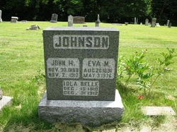
John Harvey Johnson
| Birth | : | 30 Nov 1888 Boone County, Iowa, USA |
| Death | : | 2 Nov 1912 Centerville, Appanoose County, Iowa, USA |
| Burial | : | Glen William Cemetery, Glen William, Dungog Shire, Australia |
| Coordinate | : | -32.5216700, 151.8048400 |
| Description | : | Boone County Democrat November 31, 1912 John Harvey Johnson, the son of William Johnson of Centerville, Iowa, was born at Incline, Boone county, Iowa, November 30, 1888, and died at his home in Centerville, November 2, 1912, at the age of 24 years, 11 months and 22 days after an illness of several months duration. He was united in marriage to Miss Eva Myrtle Patterson December 18, 1907. He leaves to mourn his loss a wife, one little daughter two years old, father, mother, two sisters and one brother and a host of relatives and friends. The funeral... Read More |
frequently asked questions (FAQ):
-
Where is John Harvey Johnson's memorial?
John Harvey Johnson's memorial is located at: Glen William Cemetery, Glen William, Dungog Shire, Australia.
-
When did John Harvey Johnson death?
John Harvey Johnson death on 2 Nov 1912 in Centerville, Appanoose County, Iowa, USA
-
Where are the coordinates of the John Harvey Johnson's memorial?
Latitude: -32.5216700
Longitude: 151.8048400
Family Members:
Parent
Spouse
Siblings

Children

Flowers:


Nearby Cemetories:
1. Glen William Cemetery
Glen William, Dungog Shire, Australia
Coordinate: -32.5216700, 151.8048400
2. Clarence Town Anglican Cemetery
Clarence Town, Dungog Shire, Australia
Coordinate: -32.5875850, 151.7810210
3. Clarence Town General Cemetery
Clarence Town, Dungog Shire, Australia
Coordinate: -32.5872990, 151.7613480
4. Thalaba Baptist Community Cemetery
Dungog, Dungog Shire, Australia
Coordinate: -32.4437900, 151.7841030
5. Hooke Family Cemetery
Wirragulla, Dungog Shire, Australia
Coordinate: -32.4454490, 151.7507070
6. Dungog General Cemetery
Dungog, Dungog Shire, Australia
Coordinate: -32.4188490, 151.7382580
7. Dungog Anglican Church Columbarium
Dungog, Dungog Shire, Australia
Coordinate: -32.4062660, 151.7569690
8. Dungog Presbyterian Columbarium
Dungog, Dungog Shire, Australia
Coordinate: -32.4054570, 151.7572590
9. Hilldale Union Church Columbarium
Hilldale, Dungog Shire, Australia
Coordinate: -32.5033190, 151.6567690
10. Dungog Uniting Church
Dungog, Dungog Shire, Australia
Coordinate: -32.4005385, 151.7576070
11. Booral Saint Barnabas Church Cemetery
Booral, Mid-Coast Council, Australia
Coordinate: -32.4753844, 151.9585565
12. Seaham Cemetery
Seaham, Port Stephens Council, Australia
Coordinate: -32.6679000, 151.7152860
13. St. Paul's Anglican Church Cemetery
Paterson, Dungog Shire, Australia
Coordinate: -32.6004660, 151.6185510
14. Stroud Anglican Cemetery
Stroud, Mid-Coast Council, Australia
Coordinate: -32.4052620, 151.9677280
15. Paterson Cemetery
Paterson, Dungog Shire, Australia
Coordinate: -32.6066390, 151.6077660
16. Stroud General Cemetery and Columbarium
Stroud, Mid-Coast Council, Australia
Coordinate: -32.4031170, 151.9756360
17. Karuah Cemetery
Karuah, Port Stephens Council, Australia
Coordinate: -32.6544997, 151.9604885
18. Vacy Anglican Cemetery
Vacy, Dungog Shire, Australia
Coordinate: -32.5426790, 151.5766600
19. Bendolba Anglican Cemetery
Bendolba, Dungog Shire, Australia
Coordinate: -32.3210790, 151.7249510
20. Bendolba General & War Cemetery
Bendolba, Dungog Shire, Australia
Coordinate: -32.3209930, 151.7251180
21. St. Helen’s Catholic Cemetery
Gresford, Dungog Shire, Australia
Coordinate: -32.4333344, 151.5666656
22. East Gresford Catholic Cemetery
East Gresford, Dungog Shire, Australia
Coordinate: -32.4334180, 151.5548250
23. Summer Hill Cemetery
Vacy, Dungog Shire, Australia
Coordinate: -32.5177630, 151.5321970
24. East Gresford Cemetery
East Gresford, Dungog Shire, Australia
Coordinate: -32.4262660, 151.5559390