


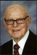
John Hathaway Reed
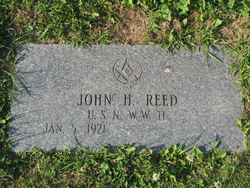
| Birth | : | 5 Jan 1921 Fort Fairfield, Aroostook County, Maine, USA |
| Death | : | 31 Oct 2012 Washington, District of Columbia, District of Columbia, USA |
| Burial | : | Riverside Cemetery, Fort Fairfield, Aroostook County, USA |
| Coordinate | : | 46.7750015, -67.8060989 |
| Inscription | : | Governor of Maine 1959-1967 |
| Description | : | Governor of Maine. He graduated from the University of Maine in 1942 and served in the United States Navy in World War II. Following the war Reed established himself as a potato farmer and became active in several business ventures. A Republican, he served on Maine's Water Improvement Commission from 1953 to 1954. In 1954 he won a seat in the Maine House of Representatives, where he served from 1955 to 1957. In 1956 Reed was a successful candidate for the Maine Senate, where he served from 1957 to 1959. He was serving as Senate President when Governor Clinton Clauson... Read More |
frequently asked questions (FAQ):
-
Where is John Hathaway Reed's memorial?
John Hathaway Reed's memorial is located at: Riverside Cemetery, Fort Fairfield, Aroostook County, USA.
-
When did John Hathaway Reed death?
John Hathaway Reed death on 31 Oct 2012 in Washington, District of Columbia, District of Columbia, USA
-
Where are the coordinates of the John Hathaway Reed's memorial?
Latitude: 46.7750015
Longitude: -67.8060989
Family Members:
Parent

Spouse
Siblings
Children
Flowers:


Nearby Cemetories:
1. Riverside Cemetery
Fort Fairfield, Aroostook County, USA
Coordinate: 46.7750015, -67.8060989
2. Saint Denis Catholic Cemetery
Fort Fairfield, Aroostook County, USA
Coordinate: 46.7773440, -67.8355030
3. Harvey Hill Cemetery
McShea, Aroostook County, USA
Coordinate: 46.7567099, -67.8652997
4. Union Cemetery
Fort Fairfield, Aroostook County, USA
Coordinate: 46.7566150, -67.8655240
5. Our Lady of Mercy Cemetery
Aroostook, Victoria County, Canada
Coordinate: 46.7977210, -67.7263700
6. Haines Maple Grove Cemetery
Fort Fairfield, Aroostook County, USA
Coordinate: 46.7233160, -67.8699040
7. Saint Ann Parish - Tobique First Nation Cemetery
Tobique, Victoria County, Canada
Coordinate: 46.7692510, -67.7055300
8. St. John The Evangelist Anglican Cemetery
Four Falls, Victoria County, Canada
Coordinate: 46.8278880, -67.7366425
9. Saint Mary of the Angels
Perth-Andover, Victoria County, Canada
Coordinate: 46.7607665, -67.7018074
10. Presbyterian Rural Cemetery
Perth-Andover, Victoria County, Canada
Coordinate: 46.7600894, -67.7013150
11. Wark Cemetery
Perth-Andover, Victoria County, Canada
Coordinate: 46.7286569, -67.7205736
12. Trinity Anglican Church Cemetery
Perth-Andover, Victoria County, Canada
Coordinate: 46.7571174, -67.6990229
13. Hillcrest Cemetery
Perth-Andover, Victoria County, Canada
Coordinate: 46.7431800, -67.7044100
14. Old Methodist Church Cemetery
Perth-Andover, Victoria County, Canada
Coordinate: 46.7506500, -67.6967900
15. Perth-Andover Baptist Church Cemetery
Perth-Andover, Victoria County, Canada
Coordinate: 46.7478522, -67.6969303
16. Larlee Creek Cemetery
Perth-Andover, Victoria County, Canada
Coordinate: 46.7147700, -67.7183500
17. Greenridge Cemetery
Caribou, Aroostook County, USA
Coordinate: 46.7923622, -67.9321976
18. Old Langley Cemetery
California Settlement, Victoria County, Canada
Coordinate: 46.8671210, -67.7631380
19. Knight Cemetery
Fort Fairfield, Aroostook County, USA
Coordinate: 46.6876150, -67.8778140
20. Kenneson Cemetery
Limestone, Aroostook County, USA
Coordinate: 46.8797900, -67.8047921
21. Bean Family Cemetery
Aroostook County, USA
Coordinate: 46.7396440, -67.9542600
22. Pine Tree Cemetery
Easton, Aroostook County, USA
Coordinate: 46.6774640, -67.8727940
23. Currie Cemetery
North Tilley, Victoria County, Canada
Coordinate: 46.8491850, -67.6886480
24. Beaconsfield Baptist Church Cemetery
Beaconsfield, Victoria County, Canada
Coordinate: 46.6640360, -67.7803850