
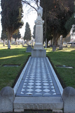

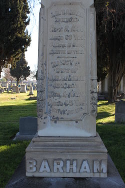
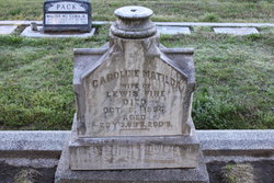
John Henry Barham
| Birth | : | 29 Apr 1829 Franklin, Williamson County, Tennessee, USA |
| Death | : | 9 Sep 1888 La Grange, Stanislaus County, California, USA |
| Burial | : | Modesto Pioneer Cemetery, Modesto, Stanislaus County, USA |
| Coordinate | : | 37.6473350, -120.9829040 |
| Plot | : | Block 33 Lot 1 Grave 5 |
| Description | : | #46947920: Merced Express, 15 Sep 1888, p3c4 Death of J. H. Barham Last Sunday John Henry Barham, a prominent and prosperous farmer, had died at his ranch near Robert's Ferry after an illness of three days from congestion of the bowels. Mr Barham had been ailing for some months from rheumatism, but of late had been in better health. On Thursday last the deceased went to an adjoining ranch on business and became overheated, and drank heartily of cold water. Soon after he was taken with cramps from which he died Sunday morning at 6 o'clock. Mr Barham came to... Read More |
frequently asked questions (FAQ):
-
Where is John Henry Barham's memorial?
John Henry Barham's memorial is located at: Modesto Pioneer Cemetery, Modesto, Stanislaus County, USA.
-
When did John Henry Barham death?
John Henry Barham death on 9 Sep 1888 in La Grange, Stanislaus County, California, USA
-
Where are the coordinates of the John Henry Barham's memorial?
Latitude: 37.6473350
Longitude: -120.9829040
Family Members:
Spouse
Children
Flowers:


Nearby Cemetories:
1. Modesto Pioneer Cemetery
Modesto, Stanislaus County, USA
Coordinate: 37.6473350, -120.9829040
2. Acacia Memorial Park
Modesto, Stanislaus County, USA
Coordinate: 37.6481080, -120.9836610
3. Modesto Citizens Cemetery
Modesto, Stanislaus County, USA
Coordinate: 37.6472930, -120.9845570
4. Saint Stanislaus Catholic Cemetery
Modesto, Stanislaus County, USA
Coordinate: 37.6473610, -120.9808440
5. Modesto County Cemetery
Modesto, Stanislaus County, USA
Coordinate: 37.6492400, -120.9813800
6. Ceres Memorial Park
Ceres, Stanislaus County, USA
Coordinate: 37.5958214, -120.9634399
7. Lakewood Memorial Park
Hughson, Stanislaus County, USA
Coordinate: 37.6199760, -120.8975983
8. Good Shepherd Catholic Cemetery
Modesto, Stanislaus County, USA
Coordinate: 37.6853130, -121.0672890
9. Wood Colony Cemetery
Salida, Stanislaus County, USA
Coordinate: 37.6893730, -121.0682144
10. Burwood Cemetery
Escalon, San Joaquin County, USA
Coordinate: 37.7616997, -120.9593964
11. Langworth Cemetery
Oakdale, Stanislaus County, USA
Coordinate: 37.7580986, -120.8957977
12. Ripon Cemetery
Ripon, San Joaquin County, USA
Coordinate: 37.7420311, -121.1238708
13. Oakdale Citizens Cemetery
Oakdale, Stanislaus County, USA
Coordinate: 37.7624600, -120.8388800
14. Oaklawn Memorial Park
Oakdale, Stanislaus County, USA
Coordinate: 37.7711945, -120.8486862
15. Saint John's Catholic Cemetery
Escalon, San Joaquin County, USA
Coordinate: 37.7994537, -121.0705185
16. Denair Cemetery
Denair, Stanislaus County, USA
Coordinate: 37.5293999, -120.8199997
17. Martin Cemetery
Waterford, Stanislaus County, USA
Coordinate: 37.6684360, -120.7582160
18. Turlock Memorial Park
Turlock, Stanislaus County, USA
Coordinate: 37.4937592, -120.8659821
19. Grayson Cemetery
Grayson, Stanislaus County, USA
Coordinate: 37.5594559, -121.1802826
20. Valley Home Memorial Park
Oakdale, Stanislaus County, USA
Coordinate: 37.8275528, -120.9333267
21. Saint Francis Episcopal Church Columbarium
Turlock, Stanislaus County, USA
Coordinate: 37.5014300, -120.8368400
22. Patterson District Cemetery
Patterson, Stanislaus County, USA
Coordinate: 37.5268135, -121.1728287
23. Atlanta Cemetery
Five Corners, San Joaquin County, USA
Coordinate: 37.8270035, -121.1420135
24. North Hilmar Cemetery
Hilmar, Merced County, USA
Coordinate: 37.4146614, -120.8864288