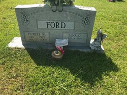
| Birth | : | 6 Jul 1927 Grassy Fork, Cocke County, Tennessee, USA |
| Death | : | 23 Jan 2002 Union County, South Carolina, USA |
| Burial | : | Midgic Cemetery, Midgic, Westmorland County, Canada |
| Coordinate | : | 45.9738500, -64.2922100 |
| Description | : | UNION - John Henry Ford, 74, of 204 Bennett St. died Jan. 23, 2002 at Wallace Thomson Hospital. A native of Grassy Fork, Tenn., he was the husband of Evelyn Smith Ford and son of the late John Tip and Nettie Greene Ford. He was a member of New Hope Baptist Church of Buffalo, Masonic Lodge No. 261, Buffalo Redman Tribe No. 40, BPO Elk's Lodge No. 1321, Union County Shrine Club and the Hejaz Shrine Temple. He was a veteran of the Navy, having served during World War II and was retired from the Union... Read More |
frequently asked questions (FAQ):
-
Where is John Henry Ford's memorial?
John Henry Ford's memorial is located at: Midgic Cemetery, Midgic, Westmorland County, Canada.
-
When did John Henry Ford death?
John Henry Ford death on 23 Jan 2002 in Union County, South Carolina, USA
-
Where are the coordinates of the John Henry Ford's memorial?
Latitude: 45.9738500
Longitude: -64.2922100
Family Members:
Parent
Siblings
Flowers:
Nearby Cemetories:
1. Midgic Cemetery
Midgic, Westmorland County, Canada
Coordinate: 45.9738500, -64.2922100
2. Four Corners Burying Ground
Upper Sackville, Westmorland County, Canada
Coordinate: 45.9358700, -64.3407200
3. Pioneer Cemetery
Westmorland County, Canada
Coordinate: 45.9359100, -64.2343500
4. Upper Pointe de Bute Baptist Cemetery
Point de Bute, Westmorland County, Canada
Coordinate: 45.9249300, -64.2197200
5. Methodist Burying Ground
Middle Sackville, Westmorland County, Canada
Coordinate: 45.9174100, -64.3689200
6. Holy Rosary & St-Vincent Ferrier
Sackville, Westmorland County, Canada
Coordinate: 45.9250500, -64.3811110
7. Point de Bute Methodist Cemetery
Point de Bute, Westmorland County, Canada
Coordinate: 45.8944670, -64.2483130
8. Sackville United Church Cemetery
Sackville, Westmorland County, Canada
Coordinate: 45.8986600, -64.3681600
9. Lower Sackville Methodist Cemetery
Sackville, Westmorland County, Canada
Coordinate: 45.8997900, -64.3705100
10. Cookville Cemetery
Cookville, Westmorland County, Canada
Coordinate: 46.0506070, -64.3659240
11. Saint Mark's Anglican Cemetery
Sackville, Westmorland County, Canada
Coordinate: 45.8816520, -64.2611090
12. Sackville Rural Cemetery
Sackville, Westmorland County, Canada
Coordinate: 45.9008500, -64.3793700
13. Fowler Cemetery
Aulac, Westmorland County, Canada
Coordinate: 45.8773300, -64.2900500
14. Watson King Burial Site
Aulac, Westmorland County, Canada
Coordinate: 45.8700200, -64.2897600
15. Fort Beausejour-Fort Cumberland
Aulac, Westmorland County, Canada
Coordinate: 45.8638600, -64.2921500
16. Fowler Cemetery
Sackville, Westmorland County, Canada
Coordinate: 45.8627500, -64.2947100
17. Fort Cumberland
Aulac, Westmorland County, Canada
Coordinate: 45.8617700, -64.2960600
18. Fort Lawrence Cemetery
Fort Lawrence, Cumberland County, Canada
Coordinate: 45.8592100, -64.2499700
19. Westcock Cemetery
Westcock, Westmorland County, Canada
Coordinate: 45.8699300, -64.3773100
20. Upper Fairfield Road Cemetery
Fairfield, Westmorland County, Canada
Coordinate: 45.9226900, -64.4620700
21. Woodhurst Cemetery
Woodhurst, Westmorland County, Canada
Coordinate: 45.9483600, -64.4859900
22. Baie Verte Cemetery
Baie-Verte, Westmorland County, Canada
Coordinate: 46.0270050, -64.1060830
23. Anderson Settlement Cemetery
Anderson Settlement, Westmorland County, Canada
Coordinate: 46.1148880, -64.2459160
24. Christ Church Cemetery
Amherst, Cumberland County, Canada
Coordinate: 45.8229680, -64.2247580


