
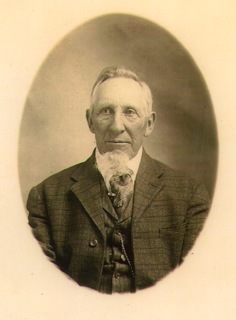
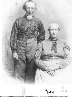
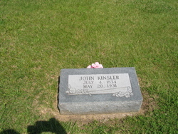
John Kinsler
| Birth | : | 4 Jul 1834 Missouri, USA |
| Death | : | 20 May 1931 Kansas, USA |
| Burial | : | Indianapolis Cemetery, Rose Hill, Mahaska County, USA |
| Coordinate | : | 41.4053001, -92.4364014 |
| Plot | : | Block 15, Lot 4 |
| Description | : | Article from Wichita Eagle, Sunday 3/15/1925: Wedding Coat of 1860 Still Worn by Mulvane Man Claw Hammer Garment of Uncle John Kinsler Still Serves Him Well Wore Pants 44 Years Mulvane, Kansas - March 14 (1925) - Sixty-five years ago, 'Uncle John' Kinsler of near Mulvane was married in St. Louis. Uncle John, as every man, woman and child in this vicinity know him, admits that he was something of a 'cake-eater' in those days so he bought a real wedding suit, claw-hammer tail and all, and was 'spliced' in it... Read More |
frequently asked questions (FAQ):
-
Where is John Kinsler's memorial?
John Kinsler's memorial is located at: Indianapolis Cemetery, Rose Hill, Mahaska County, USA.
-
When did John Kinsler death?
John Kinsler death on 20 May 1931 in Kansas, USA
-
Where are the coordinates of the John Kinsler's memorial?
Latitude: 41.4053001
Longitude: -92.4364014
Family Members:
Flowers:


Nearby Cemetories:
1. Indianapolis Cemetery
Rose Hill, Mahaska County, USA
Coordinate: 41.4053001, -92.4364014
2. Tinsley Cemetery
Mahaska County, USA
Coordinate: 41.3941994, -92.4783020
3. Bedwell Cemetery
Monroe Township, Mahaska County, USA
Coordinate: 41.3667400, -92.4637400
4. Rice Cemetery
What Cheer, Keokuk County, USA
Coordinate: 41.3793983, -92.3891983
5. Coal Creek Cemetery
What Cheer, Keokuk County, USA
Coordinate: 41.4392520, -92.3843340
6. Hopewell Cemetery
Rose Hill, Mahaska County, USA
Coordinate: 41.3502998, -92.4494019
7. Waddell Cemetery
Keokuk County, USA
Coordinate: 41.3574982, -92.3874969
8. Mormon Point Cemetery
Mahaska County, USA
Coordinate: 41.4344406, -92.5080566
9. Turner-Tinkerville-Wapalo Cemetery
Rose Hill, Mahaska County, USA
Coordinate: 41.3426130, -92.4177970
10. Roberts Cemetery
Mahaska County, USA
Coordinate: 41.3793983, -92.5235977
11. Highland Cemetery
What Cheer, Keokuk County, USA
Coordinate: 41.3936005, -92.3407974
12. McFarlan Cemetery
What Cheer, Keokuk County, USA
Coordinate: 41.4085999, -92.3371964
13. Wymore Cemetery
Rose Hill, Mahaska County, USA
Coordinate: 41.3499985, -92.5069427
14. Saint Josephs Cemetery
What Cheer, Keokuk County, USA
Coordinate: 41.4007988, -92.3300018
15. Sixteen Cemetery
Thornburg, Keokuk County, USA
Coordinate: 41.4622002, -92.3538971
16. Hewitt Cemetery
Delta, Keokuk County, USA
Coordinate: 41.3277874, -92.3807409
17. Jackson Cemetery
Rose Hill, Mahaska County, USA
Coordinate: 41.3191986, -92.4730988
18. Springfield Cemetery
Delta, Keokuk County, USA
Coordinate: 41.3386002, -92.3531036
19. Old Rose Hill Cemetery
Rose Hill, Mahaska County, USA
Coordinate: 41.3209991, -92.4929962
20. Ruby Cemetery
Lacey, Mahaska County, USA
Coordinate: 41.3633320, -92.5527550
21. Barnes City Cemetery
Barnes City, Mahaska County, USA
Coordinate: 41.5036390, -92.4746930
22. Saint Martin Evangelical Lutheran Cemetery
Keokuk County, USA
Coordinate: 41.4100075, -92.2971268
23. Humes Cemetery
Thornburg, Keokuk County, USA
Coordinate: 41.4085999, -92.2968979
24. Union Mills Cemetery
Union Mills, Mahaska County, USA
Coordinate: 41.4482994, -92.5643997