
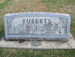
John Lane Roberts
| Birth | : | 27 Jan 1870 Morrison, Whiteside County, Illinois, USA |
| Death | : | 2 Mar 1960 Hampton, Franklin County, Iowa, USA |
| Burial | : | Way Side Cemetery, Chapin, Franklin County, USA |
| Coordinate | : | 42.8293991, -93.2225037 |
| Description | : | From the Waterloo Daily Courier - March 4, 1960 Page 5 HAMPTON - John L. Roberts, 90, Wednesday, at the Thies nursing home in Hampton, where he had been since the death of his wife in 1953; funeral Saturday at 2 p.m. at the Green & Sietsema funeral home in Hampton; burial in Chapin cemetery; survived by a son, Donald B. Roberts, Costa Mesa, Calif. Many thanks to Find A Grave Contributor, Joyce Sheumaker #47799552 for providing correct birth location, parent and spouse links. Your contributions are greatly appreciated. Although obit indicates burial at Chapin Cemetery,... Read More |
frequently asked questions (FAQ):
-
Where is John Lane Roberts's memorial?
John Lane Roberts's memorial is located at: Way Side Cemetery, Chapin, Franklin County, USA.
-
When did John Lane Roberts death?
John Lane Roberts death on 2 Mar 1960 in Hampton, Franklin County, Iowa, USA
-
Where are the coordinates of the John Lane Roberts's memorial?
Latitude: 42.8293991
Longitude: -93.2225037
Family Members:
Parent

Spouse

Siblings
Children
Flowers:


Nearby Cemetories:
1. Way Side Cemetery
Chapin, Franklin County, USA
Coordinate: 42.8293991, -93.2225037
2. Old Chapin Cemetery
Chapin, Franklin County, USA
Coordinate: 42.8232994, -93.2624969
3. Trinity Lutheran Cemetery
Hampton, Franklin County, USA
Coordinate: 42.7667007, -93.2518997
4. Zion Reformed Church Cemetery
Franklin County, USA
Coordinate: 42.8413887, -93.3188934
5. Hillside Cemetery
Sheffield, Franklin County, USA
Coordinate: 42.9006004, -93.2007980
6. Shobes Grove Cemetery
Franklin County, USA
Coordinate: 42.9000015, -93.2722168
7. Hampton Cemetery
Hampton, Franklin County, USA
Coordinate: 42.7452812, -93.1975021
8. Saint John Zion Cemetery
Sheffield, Franklin County, USA
Coordinate: 42.8969002, -93.1472015
9. Marion Center Cemetery
Latimer, Franklin County, USA
Coordinate: 42.7738991, -93.3178024
10. Hansell Cemetery
Franklin County, USA
Coordinate: 42.7666702, -93.1047211
11. West Fork Cemetery
Franklin County, USA
Coordinate: 42.8918991, -93.0836029
12. Saint Pauls Evangelical Lutheran Cemetery
Latimer, Franklin County, USA
Coordinate: 42.7652817, -93.3719406
13. Sacred Heart Cemetery
Rockwell, Cerro Gordo County, USA
Coordinate: 42.9592018, -93.1913986
14. Richland Lutheran Cemetery
Thornton, Cerro Gordo County, USA
Coordinate: 42.9086113, -93.3683319
15. Saint Johns Lutheran Cemetery
Hampton, Franklin County, USA
Coordinate: 42.7197189, -93.3397217
16. Pleasant Valley Township Cemetery
Swaledale, Cerro Gordo County, USA
Coordinate: 42.9505615, -93.3216705
17. Coulter Cemetery
Coulter, Franklin County, USA
Coordinate: 42.7388916, -93.3716736
18. Towle Cemetery
Geneva, Franklin County, USA
Coordinate: 42.6836014, -93.1785965
19. Rockwell Cemetery
Rockwell, Cerro Gordo County, USA
Coordinate: 42.9786000, -93.1919000
20. Lindenwood Cemetery
Geneva, Franklin County, USA
Coordinate: 42.6935997, -93.1235962
21. Saint Peter's Lutheran Church Cemetery
Coulter, Franklin County, USA
Coordinate: 42.7167015, -93.3803024
22. Harlan Cemetery
Dumont, Butler County, USA
Coordinate: 42.7663994, -93.0143967
23. Four Mile Grove Cemetery
Geneva, Franklin County, USA
Coordinate: 42.6949997, -93.0852966
24. Saint Patricks Catholic Cemetery
Dougherty, Cerro Gordo County, USA
Coordinate: 42.9227791, -93.0294418