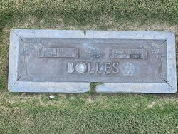
| Birth | : | 26 Sep 1889 Texas, USA |
| Death | : | 30 May 1974 Grand Junction, Mesa County, Colorado, USA |
| Burial | : | Orchard Mesa Cemetery, Grand Junction, Mesa County, USA |
| Coordinate | : | 39.0426500, -108.5664000 |
| Plot | : | Block H |
| Description | : | John Lee Bolles, 84, a retired Forest Service employee, died at 4:15 p.m. Thursday in Teller Arms Nursing Home. A resident of Grand Junction 35 years, he had served as construction foreman on the Grand Mesa Forest for a number of years. One of the projects he supervised was the building of the Lands End observatory. Born on Sept. 26, 1889, at Seep Springs, Tex., he spent his early life in Indian Territory, later Oklahoma. He married Jewel Lindsey at Foster, Okla., in 1911. They came to Colorado in 1934. He attended the Seventh-day Adventist Church. Surviving in addition... Read More |
frequently asked questions (FAQ):
-
Where is John Lee Bolles's memorial?
John Lee Bolles's memorial is located at: Orchard Mesa Cemetery, Grand Junction, Mesa County, USA.
-
When did John Lee Bolles death?
John Lee Bolles death on 30 May 1974 in Grand Junction, Mesa County, Colorado, USA
-
Where are the coordinates of the John Lee Bolles's memorial?
Latitude: 39.0426500
Longitude: -108.5664000
Family Members:
Parent
Spouse
Siblings
Children
Flowers:
Nearby Cemetories:
1. Orchard Mesa Cemetery
Grand Junction, Mesa County, USA
Coordinate: 39.0426500, -108.5664000
2. Masonic Cemetery
Grand Junction, Mesa County, USA
Coordinate: 39.0442276, -108.5670471
3. IOOF Cemetery
Grand Junction, Mesa County, USA
Coordinate: 39.0447500, -108.5679500
4. Saint Anthony Cemetery
Grand Junction, Mesa County, USA
Coordinate: 39.0454000, -108.5660000
5. Veterans Cemetery
Grand Junction, Mesa County, USA
Coordinate: 39.0444946, -108.5690918
6. Calvary Cemetery
Grand Junction, Mesa County, USA
Coordinate: 39.0456009, -108.5653000
7. Potters Field
Grand Junction, Mesa County, USA
Coordinate: 39.0413284, -108.5700989
8. Ohr Shalom Cemetery
Grand Junction, Mesa County, USA
Coordinate: 39.0460000, -108.5665000
9. Fair View Cemetery
Grand Junction, Mesa County, USA
Coordinate: 39.0465000, -108.5660000
10. Municipal Cemetery
Grand Junction, Mesa County, USA
Coordinate: 39.0477028, -108.5673676
11. Ross Cemetery
Grand Junction, Mesa County, USA
Coordinate: 39.0695660, -108.5637030
12. Teller Indian School Cemetery
Grand Junction, Mesa County, USA
Coordinate: 39.0631400, -108.5316130
13. Veterans Memorial Cemetery of Western Colorado
Grand Junction, Mesa County, USA
Coordinate: 39.0631447, -108.5261002
14. Memorial Gardens
Grand Junction, Mesa County, USA
Coordinate: 39.0790329, -108.5022278
15. Saint Matthews Episcopal Church Memorial Garden
Grand Junction, Mesa County, USA
Coordinate: 39.1021440, -108.5422860
16. Immaculate Heart of Mary Columbarium
Grand Junction, Mesa County, USA
Coordinate: 39.1195000, -108.5600000
17. Final Paws Pet Cemetery
Grand Junction, Mesa County, USA
Coordinate: 39.1205000, -108.6240000
18. Little Park Cemetery
Grand Junction, Mesa County, USA
Coordinate: 38.9863500, -108.6604500
19. Crown Point Cemetery
Grand Junction, Mesa County, USA
Coordinate: 39.1425018, -108.6175003
20. Whitewater Cemetery
Whitewater, Mesa County, USA
Coordinate: 38.9818993, -108.4357986
21. Glade Park Cemetery
Mesa County, USA
Coordinate: 39.0074997, -108.7382965
22. Palisade Cemetery
Palisade, Mesa County, USA
Coordinate: 39.0999000, -108.3980000
23. Sacred Heart Cemetery
Fruita, Mesa County, USA
Coordinate: 39.1721992, -108.7292023
24. Elmwood Cemetery
Fruita, Mesa County, USA
Coordinate: 39.1739006, -108.7339020


