
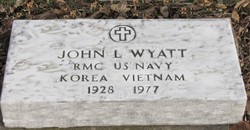
John Lee Wyatt
| Birth | : | 30 Nov 1928 Kellogg, Shoshone County, Idaho, USA |
| Death | : | 27 May 1977 Hadar, Pierce County, Nebraska, USA |
| Burial | : | Queens Meadow Point Cemetery, Keyser, Mineral County, USA |
| Coordinate | : | 39.4291992, -78.9627991 |
| Plot | : | 895 |
| Description | : | Parents: Delany Wyatt and Delphia Riggle RMC US Navy Korea, Vietnam |
frequently asked questions (FAQ):
-
Where is John Lee Wyatt's memorial?
John Lee Wyatt's memorial is located at: Queens Meadow Point Cemetery, Keyser, Mineral County, USA.
-
When did John Lee Wyatt death?
John Lee Wyatt death on 27 May 1977 in Hadar, Pierce County, Nebraska, USA
-
Where are the coordinates of the John Lee Wyatt's memorial?
Latitude: 39.4291992
Longitude: -78.9627991
Family Members:
Spouse
Flowers:


Nearby Cemetories:
1. Queens Meadow Point Cemetery
Keyser, Mineral County, USA
Coordinate: 39.4291992, -78.9627991
2. Potomac Memorial Gardens
Keyser, Mineral County, USA
Coordinate: 39.4312000, -78.9579700
3. Dayton Cemetery
McCoole, Allegany County, USA
Coordinate: 39.4437000, -78.9573400
4. Locust Cemetery
Keyser, Mineral County, USA
Coordinate: 39.4449577, -78.9769135
5. Town Hill Cemetery
Petersburg, Grant County, USA
Coordinate: 39.4351762, -78.9882074
6. Thorn Rose Hill Cemetery
Keyser, Mineral County, USA
Coordinate: 39.4374352, -78.9929199
7. Arnold Cemetery
Keyser, Mineral County, USA
Coordinate: 39.4263992, -78.9950027
8. Saint Thomas Cemetery
Keyser, Mineral County, USA
Coordinate: 39.4406900, -78.9960300
9. Saint Mary's Cemetery
Keyser, Mineral County, USA
Coordinate: 39.4403000, -78.9963989
10. Cabin Run Cemetery
Keyser, Mineral County, USA
Coordinate: 39.4206009, -78.9216995
11. Sears Cemetery
Mineral County, USA
Coordinate: 39.4026900, -78.9148200
12. Leatherman-Parish Cemetery
Keyser, Mineral County, USA
Coordinate: 39.4075080, -79.0150020
13. Dawson Cemetery
Dawson, Allegany County, USA
Coordinate: 39.4737360, -78.9464880
14. Barrick and Rines Cemetery
Mineral County, USA
Coordinate: 39.3994010, -79.0143540
15. Duling Cemetery
New Creek, Mineral County, USA
Coordinate: 39.3906525, -79.0041940
16. County Poor House Cemetery
Mineral County, USA
Coordinate: 39.4788710, -78.9411070
17. Mount Zion Cemetery
Mineral County, USA
Coordinate: 39.4642900, -78.8974500
18. Orr Cemetery
Independence, Preston County, USA
Coordinate: 39.4252620, -78.8777500
19. Urice Cemetery
Mineral County, USA
Coordinate: 39.4687400, -78.8923000
20. Miller Cemetery
Westernport, Allegany County, USA
Coordinate: 39.4888110, -79.0043140
21. Bane Cemetery
Burlington, Mineral County, USA
Coordinate: 39.3579200, -78.9598200
22. Thrush Cemetery #01
Burlington, Mineral County, USA
Coordinate: 39.3588200, -78.9289400
23. Arnold Cemetery #2
Ridgeville, Mineral County, USA
Coordinate: 39.3612890, -79.0072440
24. Duckworth Cemetery at Stoney Run
Westernport, Allegany County, USA
Coordinate: 39.4984280, -79.0136400