
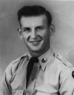
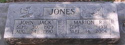
John Newell “Jack” Jones
| Birth | : | 30 Sep 1929 Maxwell, Colusa County, California, USA |
| Death | : | 24 Aug 1990 Paynes Creek, Tehama County, California, USA |
| Burial | : | Mount Calvary Catholic Cemetery, Galion, Crawford County, USA |
| Coordinate | : | 40.7498660, -82.7811778 |
| Plot | : | Blk 10s |
frequently asked questions (FAQ):
-
Where is John Newell “Jack” Jones's memorial?
John Newell “Jack” Jones's memorial is located at: Mount Calvary Catholic Cemetery, Galion, Crawford County, USA.
-
When did John Newell “Jack” Jones death?
John Newell “Jack” Jones death on 24 Aug 1990 in Paynes Creek, Tehama County, California, USA
-
Where are the coordinates of the John Newell “Jack” Jones's memorial?
Latitude: 40.7498660
Longitude: -82.7811778
Family Members:
Parent
Spouse
Siblings
Flowers:


Nearby Cemetories:
1. Mount Calvary Catholic Cemetery
Galion, Crawford County, USA
Coordinate: 40.7498660, -82.7811778
2. Galion Mausoleum
Galion, Crawford County, USA
Coordinate: 40.7490980, -82.7810380
3. Fairview Cemetery
Galion, Crawford County, USA
Coordinate: 40.7508908, -82.7793469
4. Union Green Cemetery
Galion, Crawford County, USA
Coordinate: 40.7359860, -82.7919280
5. Peace Lutheran Church Columbarium
Galion, Crawford County, USA
Coordinate: 40.7331469, -82.7897680
6. Middletown Cemetery
Middletown, Crawford County, USA
Coordinate: 40.7701090, -82.7915850
7. Barnes-Talbot Cemetery
Galion, Crawford County, USA
Coordinate: 40.7698000, -82.7592500
8. Gledhill Cemetery
Middletown, Crawford County, USA
Coordinate: 40.7751350, -82.7940420
9. John Smith Family Farm Cemetery
Galion, Crawford County, USA
Coordinate: 40.7570100, -82.8186320
10. Line Cemetery
Galion, Crawford County, USA
Coordinate: 40.7477120, -82.7357200
11. Windfall Cemetery
North Robinson, Crawford County, USA
Coordinate: 40.7696991, -82.8199997
12. Park Cemetery
Galion, Crawford County, USA
Coordinate: 40.7266410, -82.8213790
13. Leesville Cemetery
Crawford County, USA
Coordinate: 40.7942940, -82.7914940
14. Pletcher Cemetery
Galion, Crawford County, USA
Coordinate: 40.7395348, -82.8392529
15. Autin Cemetery
Washington Township, Morrow County, USA
Coordinate: 40.7122002, -82.8264008
16. Zoar Cemetery
Crawford County, USA
Coordinate: 40.7299995, -82.8488998
17. Greenlawn Cemetery
East Crestline, Richland County, USA
Coordinate: 40.7850571, -82.7226782
18. Forbes Cemetery
Morrow County, USA
Coordinate: 40.7042007, -82.8268967
19. Saint Joseph Cemetery
Sandusky Township, Richland County, USA
Coordinate: 40.7871600, -82.7215628
20. Goodrich Cemetery
Washington Township, Morrow County, USA
Coordinate: 40.6981820, -82.8175930
21. Dye Cemetery
Morrow County, USA
Coordinate: 40.6910950, -82.7775550
22. Crawford County Memory Gardens
Crestline, Crawford County, USA
Coordinate: 40.8081128, -82.8037923
23. Blooming Grove Cemetery
Morrow County, USA
Coordinate: 40.7108911, -82.7176773
24. Tuttle Cemetery
Morrow County, USA
Coordinate: 40.6925011, -82.8210983