John Parker Richards
| Birth | : | 1907 Nova Scotia, Canada |
| Death | : | 13 Nov 1942 |
| Burial | : | Knox Presbyterian Cemetery, Dublin Shore, Lunenburg County, Canada |
| Coordinate | : | 44.2671000, -64.3747000 |
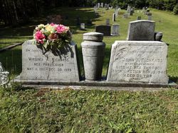
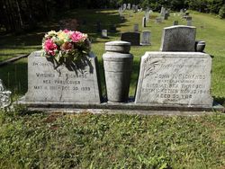
| Inscription | : | RICHARDS John P. 13 Nov 1942 35 yrs Master Mariner - died at sea through enemy act |
| Description | : | Bridgewater Bulletin Wednesday, November 25th, 1942 The "Lillian E Kerr" one of the few surviving four-masted schooners surviving, and a vessel which was a familiar sight at the railway wharf, Bridgewater, has made her last voyage. The news was received on Monday by the owner, Captain J. L. Publicover, Dublin Shore that the ship had met disaster returning from New York with a cargo of coal. She was supposedly rammed by a steamer and cut in two, sinking immediately. Of the seven men aboard the "Kerr" only one, the owner's son-in-law, John Richards, who served as mate, is known to have been... Read More |
frequently asked questions (FAQ):
-
Where is John Parker Richards's memorial?
John Parker Richards's memorial is located at: Knox Presbyterian Cemetery, Dublin Shore, Lunenburg County, Canada.
-
When did John Parker Richards death?
John Parker Richards death on 13 Nov 1942 in
-
Where are the coordinates of the John Parker Richards's memorial?
Latitude: 44.2671000
Longitude: -64.3747000
Family Members:
Spouse
Children
Flowers:
Nearby Cemetories:
1. Knox Presbyterian Cemetery
Dublin Shore, Lunenburg County, Canada
Coordinate: 44.2671000, -64.3747000
2. St. James Anglican Cemetery
Dublin Shore, Lunenburg County, Canada
Coordinate: 44.2714900, -64.3601200
3. Fort Point Cemetery
LaHave, Lunenburg County, Canada
Coordinate: 44.2888530, -64.3522230
4. Bush Island Cemetery
Bush Island, Lunenburg County, Canada
Coordinate: 44.2381750, -64.3704420
5. Old Bush Island Cemetery
Bush Island, Lunenburg County, Canada
Coordinate: 44.2376810, -64.3714610
6. Publicover Cemetery
Crescent Beach, Lunenburg County, Canada
Coordinate: 44.2433940, -64.4050830
7. Romkey Family Cemetery
Crescent Beach, Lunenburg County, Canada
Coordinate: 44.2413559, -64.4052429
8. Croft Dale Cemetery
Crescent Beach, Lunenburg County, Canada
Coordinate: 44.2453190, -64.4183110
9. Community Cemetery (Old)
East LaHave, Lunenburg County, Canada
Coordinate: 44.3053300, -64.3644400
10. Corkum Cemetery
Mount Pleasant, Lunenburg County, Canada
Coordinate: 44.2805610, -64.4270420
11. St. Luke's Cemetery
Mount Pleasant, Lunenburg County, Canada
Coordinate: 44.2743100, -64.4296600
12. Mount Pleasant United Church Cemetery
Mount Pleasant, Lunenburg County, Canada
Coordinate: 44.2734690, -64.4308070
13. Lakeside Cemetery
Mount Pleasant, Lunenburg County, Canada
Coordinate: 44.2663080, -64.4341060
14. Riverside Cemetery
East LaHave, Lunenburg County, Canada
Coordinate: 44.3080800, -64.3578600
15. Creek Hill Cemetery
East LaHave, Lunenburg County, Canada
Coordinate: 44.3057600, -64.3464700
16. Shepherd's Hill Cemetery
Riverport, Lunenburg County, Canada
Coordinate: 44.2868300, -64.3202400
17. Bell's Island Cemetery
LaHave Island, Lunenburg County, Canada
Coordinate: 44.2240970, -64.3574940
18. Lahave Island Cemetery
LaHave Island, Lunenburg County, Canada
Coordinate: 44.2240970, -64.3574940
19. Tumblin Cemetery
LaHave Island, Lunenburg County, Canada
Coordinate: 44.2238890, -64.3575640
20. Pioneer Cemetery
Riverport, Lunenburg County, Canada
Coordinate: 44.2952200, -64.3211080
21. Poplar Ridge Cemetery
New Cumberland, Lunenburg County, Canada
Coordinate: 44.2872250, -64.4351750
22. New Cumberland Cemetery
New Cumberland, Lunenburg County, Canada
Coordinate: 44.2854300, -64.4512100
23. Rose Bay Community Cemetery
Rose Bay, Lunenburg County, Canada
Coordinate: 44.2971200, -64.3050700
24. Private Cemetery
Petite Rivière Bridge, Lunenburg County, Canada
Coordinate: 44.2346300, -64.4425300


