


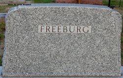
John Raymond “Ray” Freeburg
| Birth | : | 24 Jun 1923 Spencer, Clay County, Iowa, USA |
| Death | : | 28 Jan 2008 Spencer, Clay County, Iowa, USA |
| Burial | : | Riverside Cemetery, Spencer, Clay County, USA |
| Coordinate | : | 43.1441994, -95.1671982 |
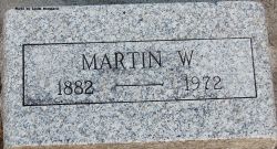
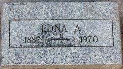
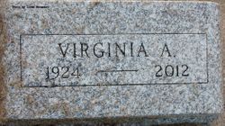
| Description | : | John Raymond (Ray) Freeburg, the son of Martin and Edna (Falline) Freeburg, was born June 24, 1923 in Spencer, Iowa. His childhood years were spent in Spencer, Iowa, where he received his education, graduating from Spencer High School. Following high school, he began farming. Ray married Virginia Ann Moeller on June 25, 1944 in Royal, Iowa. Following their marriage, they farmed until 1963, when Ray started a career with Farm Bureau Insurance, serving as division manager and then manager with Clay County Farm Bureau Insurance. Following his insurance career, Ray sold farm real estate in the Spencer area. He purchased... Read More |
frequently asked questions (FAQ):
-
Where is John Raymond “Ray” Freeburg's memorial?
John Raymond “Ray” Freeburg's memorial is located at: Riverside Cemetery, Spencer, Clay County, USA.
-
When did John Raymond “Ray” Freeburg death?
John Raymond “Ray” Freeburg death on 28 Jan 2008 in Spencer, Clay County, Iowa, USA
-
Where are the coordinates of the John Raymond “Ray” Freeburg's memorial?
Latitude: 43.1441994
Longitude: -95.1671982
Family Members:
Parent
Spouse
Flowers:


Nearby Cemetories:
1. Riverside Cemetery
Spencer, Clay County, USA
Coordinate: 43.1441994, -95.1671982
2. Dewey Readmore Books Memorial
Spencer, Clay County, USA
Coordinate: 43.1403999, -95.1443024
3. North Lawn Cemetery
Spencer, Clay County, USA
Coordinate: 43.1600000, -95.1470000
4. Evergreen Cemetery
Clay County, USA
Coordinate: 43.2052994, -95.2086029
5. Fairview Cemetery
Clay County, USA
Coordinate: 43.1899986, -95.0800018
6. Swedish Lutheran Cemetery
Royal, Clay County, USA
Coordinate: 43.0683000, -95.2350000
7. Dickens Cemetery
Dickens, Clay County, USA
Coordinate: 43.1280000, -95.0155000
8. Rosehill Cemetery
Clay County, USA
Coordinate: 43.0368996, -95.0919037
9. Lone Tree Cemetery
Everly, Clay County, USA
Coordinate: 43.1411018, -95.3347015
10. Little Sioux Lutheran Cemetery
Milford, Dickinson County, USA
Coordinate: 43.2702065, -95.2109528
11. First Reformed Cemetery
Clay County, USA
Coordinate: 43.2399500, -95.2889000
12. Lincoln Cemetery
Rossie, Clay County, USA
Coordinate: 43.0111008, -95.2313995
13. Willow Creek Cemetery
Royal, Clay County, USA
Coordinate: 43.0214005, -95.2885971
14. Liberty Cemetery
Greenville, Clay County, USA
Coordinate: 42.9897003, -95.1417007
15. Clay Center Cemetery
Royal, Clay County, USA
Coordinate: 43.0410995, -95.3272018
16. Milford Cemetery
Milford, Dickinson County, USA
Coordinate: 43.3092003, -95.1481018
17. TriMello Cemetery
Royal, Clay County, USA
Coordinate: 43.0682983, -95.3728027
18. Logan Township Cemetery
Clay County, USA
Coordinate: 43.0489006, -94.9747009
19. Zion Methodist Cemetery
Clay County, USA
Coordinate: 42.9808006, -95.2497025
20. Calvary Cemetery
Milford, Dickinson County, USA
Coordinate: 43.3213997, -95.1688995
21. Fanny Fern Cemetery
Clay County, USA
Coordinate: 42.9530983, -95.1607971
22. Crown Hill Cemetery
Ruthven, Palo Alto County, USA
Coordinate: 43.1328011, -94.8878021
23. Calvary Cemetery
Ruthven, Palo Alto County, USA
Coordinate: 43.1314011, -94.8869019
24. Westport Cemetery
Dickinson County, USA
Coordinate: 43.3130989, -95.3289032