
| Birth | : | 14 Feb 1816 Montgomery County, Maryland, USA |
| Death | : | 16 Jun 1884 Beallsville, Montgomery County, Maryland, USA |
| Burial | : | Hillcrest Memorial Park, Hurffville, Gloucester County, USA |
| Coordinate | : | 39.7491989, -75.1110992 |
| Plot | : | Central Avenue South, Lot 8 Upper, Site 4 |
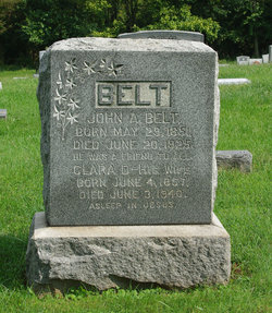
| Description | : | Parents: - William Seaton Belt [1779-1855] - Elizabeth Smith (Waters) Belt [1786-1869] Married Ann Amelia (Eagle) Belt on September 15, 1838 in Frederick County, MD. Children: - Margaret Elizabeth Belt [1839-1891] - Maria Edmonia Belt [1844-1926] - John Alyshonsis Belt [1851-?] Married (2) Mary Barbara (Leapley) Belt on December 16, 1856 in Frederick County, MD. Children: - William Edward Belt [1857-1928] - Mary Ella Belt [1859-1865] - Turner Ashby Belt [1862-1913] - Virginia Lee Belt [1866-1914] - John Richard Belt [1869-1939] - Thomas Johnson Belt [1869-1949] Death Notice The News (Frederick, MD) June 19, 1884 Mr. Richard Belt of Montgomery Co., died Monday after a long spell of sickness. |
frequently asked questions (FAQ):
-
Where is John Richard Belt's memorial?
John Richard Belt's memorial is located at: Hillcrest Memorial Park, Hurffville, Gloucester County, USA.
-
When did John Richard Belt death?
John Richard Belt death on 16 Jun 1884 in Beallsville, Montgomery County, Maryland, USA
-
Where are the coordinates of the John Richard Belt's memorial?
Latitude: 39.7491989
Longitude: -75.1110992
Family Members:
Spouse

Children
Flowers:


Nearby Cemetories:
1. Hillcrest Memorial Park
Hurffville, Gloucester County, USA
Coordinate: 39.7491989, -75.1110992
2. Bethel Methodist Church Cemetery
Hurffville, Gloucester County, USA
Coordinate: 39.7571983, -75.1110992
3. Bunker Hill Presbyterian Church Cemetery
Gloucester County, USA
Coordinate: 39.7451600, -75.0849200
4. Cost Family Cemetery
Pitman, Gloucester County, USA
Coordinate: 39.7307100, -75.1332310
5. Bunker Hill Presbyterian Church Cemetery
Sewell, Gloucester County, USA
Coordinate: 39.7767514, -75.0931293
6. Manahath Cemetery
Glassboro, Gloucester County, USA
Coordinate: 39.7154236, -75.1141129
7. Driver Cemetery
Barnsboro, Gloucester County, USA
Coordinate: 39.7631000, -75.1554900
8. Jesse Chew Cemetery
Gloucester County, USA
Coordinate: 39.7736800, -75.1498250
9. Mount Zion Methodist Church Cemetery
Barnsboro, Gloucester County, USA
Coordinate: 39.7547540, -75.1629530
10. Saint Thomas Episcopal Church Cemetery
Glassboro, Gloucester County, USA
Coordinate: 39.7079200, -75.1101500
11. First United Methodist Church Cemetery
Glassboro, Gloucester County, USA
Coordinate: 39.7068900, -75.1081300
12. Alms House Cemetery
Lakeland, Camden County, USA
Coordinate: 39.7878700, -75.0823500
13. Saint Bridgets Cemetery
Glassboro, Gloucester County, USA
Coordinate: 39.7023300, -75.1159000
14. Trinity Bible Cemetery
Glassboro, Gloucester County, USA
Coordinate: 39.7003610, -75.1133800
15. Saint Johns United Methodist Cemetery
Turnersville, Gloucester County, USA
Coordinate: 39.7598300, -75.0487100
16. Grenloch First Presbyterian Church Memorial Garden
Grenloch Terrace, Gloucester County, USA
Coordinate: 39.7806000, -75.0587000
17. Grenloch First Presbyterian Church Memory Garden
Camden County, USA
Coordinate: 39.7806000, -75.0587000
18. Richwood United Methodist Church Cemetery
Richwood, Gloucester County, USA
Coordinate: 39.7211100, -75.1667700
19. Holy Trinity Memorial Garden
Wenonah, Gloucester County, USA
Coordinate: 39.7922200, -75.1514700
20. Buffalo Soldiers Cemetery
Franklinville, Gloucester County, USA
Coordinate: 39.8010180, -75.0899580
21. Wenonah Cemetery
Wenonah, Gloucester County, USA
Coordinate: 39.7893982, -75.1622009
22. Mantua Methodist Cemetery
Mantua, Gloucester County, USA
Coordinate: 39.7883160, -75.1663420
23. Blackwood Baptist Cemetery
Blackwood, Camden County, USA
Coordinate: 39.8010521, -75.0709305
24. Mantua Union Graveyard
Mantua, Gloucester County, USA
Coordinate: 39.7902460, -75.1707610