
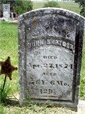
John Shryock
| Birth | : | 15 Oct 1797 Balmoral, Frederick County, Maryland, USA |
| Death | : | 27 Apr 1874 Edenville, Marshall County, Iowa, USA |
| Burial | : | Emmaus Cemetery, Point Pass, Goyder Regional Council, Australia |
| Coordinate | : | -34.1261490, 139.0694460 |
| Description | : | Shryock, pronounced in two syllables, accent on the first: "SHRY (rhymes with eye) ock (like rock, not oak)" I AM IN AWE OF THIS MAN! 65 YEARS FROM HIS BIRTH HE GOES OFF TO WAR. I DOUBT HE GOT A RIDE TO OR BACK SERVED: Union Army Civil War 37 Iowa Infantry 37th Regiment, Iowa Infantry Company I Private Enlisted 19 Nov 1862 Mustered out 24 May 1865 at Davenport, IA. FATHER: Daniel Shryock MOTHER: Mary Ann Cassell MARRIED: Jane Mary Shutts, 1806 - 1860 CHILDREN: Samuel, 1827 - 1904; Sarah Shryock, 1829 - ; Rebecca Shryock, 12 Jun 1834 - 02 Nov 1911; Francis, 1838 - 1877; Mary S. Shryock, 1839 - ; Seymour, 1840 -... Read More |
frequently asked questions (FAQ):
-
Where is John Shryock's memorial?
John Shryock's memorial is located at: Emmaus Cemetery, Point Pass, Goyder Regional Council, Australia.
-
When did John Shryock death?
John Shryock death on 27 Apr 1874 in Edenville, Marshall County, Iowa, USA
-
Where are the coordinates of the John Shryock's memorial?
Latitude: -34.1261490
Longitude: 139.0694460
Family Members:
Spouse
Children
Flowers:


Nearby Cemetories:
1. Emmaus Cemetery
Point Pass, Goyder Regional Council, Australia
Coordinate: -34.1261490, 139.0694460
2. Julia Lutheran Cemetery
Julia, Goyder Regional Council, Australia
Coordinate: -34.1140990, 139.0276290
3. Eudunda Cemetery
Eudunda, Goyder Regional Council, Australia
Coordinate: -34.1731531, 139.0956127
4. Point Pass Saint Petri Lutheran Cemetery
Point Pass, Goyder Regional Council, Australia
Coordinate: -34.0741300, 139.0543200
5. Australia Plains Cemetery
Australia Plains, Goyder Regional Council, Australia
Coordinate: -34.0981390, 139.1456490
6. Saint Michaels Lutheran Church Cemetery
Peep Hill, Goyder Regional Council, Australia
Coordinate: -34.1465130, 139.1547050
7. Tarnma Cemetery
Tarnma, District Council of Clare and Gilbert Valleys, Australia
Coordinate: -34.1466410, 138.9538210
8. Trinity Lutheran Cemetery
Neales Flat, Goyder Regional Council, Australia
Coordinate: -34.2288700, 139.1619200
9. Trinity Lutheran Cemetery
Eudunda, Goyder Regional Council, Australia
Coordinate: -34.2288890, 139.1622220
10. St. John's Lutheran Cemetery
Robertstown, Goyder Regional Council, Australia
Coordinate: -33.9924800, 139.0749500
11. Tothill Creek Cemetery
Tothill Creek, District Council of Clare and Gilbert Valleys, Australia
Coordinate: -34.0781820, 138.9170250
12. Sutherlands St Johns Lutheran Cemetery
Sutherlands, Goyder Regional Council, Australia
Coordinate: -34.1541800, 139.2302700
13. Tothill Creek St Edmund's Anglican Cemetery
Marrabel, District Council of Clare and Gilbert Valleys, Australia
Coordinate: -34.0888160, 138.9094860
14. St. Stephan's Lutheran Cemetery
Neales Flat, Goyder Regional Council, Australia
Coordinate: -34.2249500, 139.1866500
15. Zion Lutheran Cemetery
Robertstown, Goyder Regional Council, Australia
Coordinate: -33.9852890, 139.0763760
16. St. Agnes Catholic Cemetery
Marrabel, District Council of Clare and Gilbert Valleys, Australia
Coordinate: -34.1411778, 138.8630086
17. Geranium Plains St. Stephens Lutheran Church
Geranium Plains, Goyder Regional Council, Australia
Coordinate: -33.9849630, 139.1881020
18. St. Stephens Lutheran Church Cemetery
Geranium Plains, Goyder Regional Council, Australia
Coordinate: -33.9849630, 139.1881020
19. St. Philip's Anglican Church Cemetery
Marrabel, District Council of Clare and Gilbert Valleys, Australia
Coordinate: -34.1760370, 138.8658570
20. St. Matthew's Anglican Cemetery
Hamilton, Light Regional Council, Australia
Coordinate: -34.2224400, 138.8795100
21. Brady Creek Lutheran Cemetery
Brady Creek, Goyder Regional Council, Australia
Coordinate: -33.9510160, 138.9975130
22. Hamilton Methodist Church Cemetery
Hamilton, Light Regional Council, Australia
Coordinate: -34.2232310, 138.8778960
23. Bagot Well Congregational Cemetery
Kapunda, Light Regional Council, Australia
Coordinate: -34.3013790, 138.9831310
24. Apoinga Cemetery
Apoinga, Goyder Regional Council, Australia
Coordinate: -33.9603800, 138.9407500