

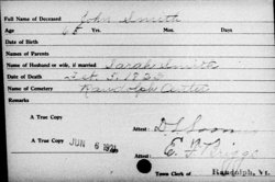
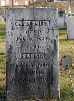
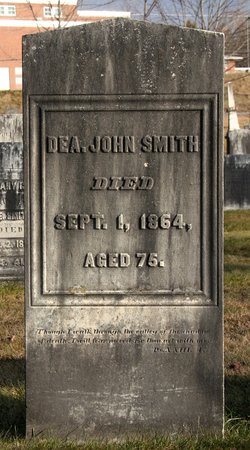
John Smith
| Birth | : | 21 Aug 1756 Lexington, Middlesex County, Massachusetts, USA |
| Death | : | 5 Feb 1822 Randolph, Orange County, Vermont, USA |
| Burial | : | Randolph Center Cemetery, Randolph Center, Orange County, USA |
| Coordinate | : | 43.9364300, -72.6045500 |
| Description | : | Son of Samuel Smith and Mary Mirick who were married 30 Nov. 1738 in Newton, Mass. Married Sarah Lawrence 15 Nov. 1781. The following information supplied by William Poole Captain Commanding Lexington Minute Men Company. John stood on Lexington Common on the morning of April 19, 1775 along with the few other members of Captain John Parker's militia company who had hastily responded to the urgent beat of William Diamond's drum. Presumably, John also joined with Captain Parker to ambush the Regulars on their return from Concord at the site in Minute Man National Historic Park known as Parker's Revenge. John then... Read More |
frequently asked questions (FAQ):
-
Where is John Smith's memorial?
John Smith's memorial is located at: Randolph Center Cemetery, Randolph Center, Orange County, USA.
-
When did John Smith death?
John Smith death on 5 Feb 1822 in Randolph, Orange County, Vermont, USA
-
Where are the coordinates of the John Smith's memorial?
Latitude: 43.9364300
Longitude: -72.6045500
Family Members:
Parent
Spouse
Children


Flowers:


Nearby Cemetories:
1. Randolph Center Cemetery
Randolph Center, Orange County, USA
Coordinate: 43.9364300, -72.6045500
2. Vermont Veterans Memorial Cemetery
Randolph Center, Orange County, USA
Coordinate: 43.9433098, -72.5971680
3. Moulton Cemetery
Randolph, Orange County, USA
Coordinate: 43.9267500, -72.6501200
4. East Randolph Cemetery
East Randolph, Orange County, USA
Coordinate: 43.9276300, -72.5532200
5. South View Cemetery
Randolph, Orange County, USA
Coordinate: 43.9168200, -72.6583200
6. Pleasant View Cemetery
Randolph, Orange County, USA
Coordinate: 43.9110600, -72.6555000
7. Holy Cross Cemetery
Randolph, Orange County, USA
Coordinate: 43.9163800, -72.6605200
8. Peth Cemetery
Braintree, Orange County, USA
Coordinate: 43.9656700, -72.6625100
9. East Braintree Cemetery
East Braintree, Orange County, USA
Coordinate: 43.9906100, -72.6491700
10. East Bethel Cemetery
East Bethel, Windsor County, USA
Coordinate: 43.8715500, -72.5843400
11. Old Christ Church Cemetery
Bethel, Windsor County, USA
Coordinate: 43.8750900, -72.6475500
12. Braintree Hill Cemetery
Braintree Hill, Orange County, USA
Coordinate: 43.9697500, -72.6881900
13. Spear Cemetery
Braintree, Orange County, USA
Coordinate: 43.9784700, -72.6839500
14. Dickerman Hill Cemetery
Tunbridge, Orange County, USA
Coordinate: 43.9599260, -72.5066130
15. Lower Branch Cemetery
Braintree, Orange County, USA
Coordinate: 43.9487100, -72.7122400
16. Carty Family Cemetery
Tunbridge, Orange County, USA
Coordinate: 43.8705500, -72.5407700
17. Whitney Hill Cemetery
Tunbridge, Orange County, USA
Coordinate: 43.9381930, -72.4929000
18. Mann Cemetery
Braintree Hill, Orange County, USA
Coordinate: 43.9987246, -72.6754138
19. Monarch Hill Cemetery
Tunbridge, Orange County, USA
Coordinate: 43.9080730, -72.4997770
20. Tunbridge Meeting House Cemetery
Tunbridge, Orange County, USA
Coordinate: 43.9077700, -72.4987000
21. Ward Hill Cemetery
Tunbridge, Orange County, USA
Coordinate: 43.8689257, -72.5370929
22. Allen Cemetery
Chelsea, Orange County, USA
Coordinate: 43.9829600, -72.5087400
23. Spring Road Cemetery
Tunbridge, Orange County, USA
Coordinate: 43.8964900, -72.4978900
24. Gilead Cemetery
Bethel, Windsor County, USA
Coordinate: 43.8730300, -72.6873300