
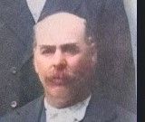
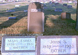
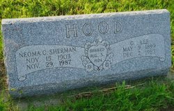
John Smith Hood
| Birth | : | 1858 Vermilion County, Illinois, USA |
| Death | : | 29 Jun 1933 Randolph, Cedar County, Nebraska, USA |
| Burial | : | Elmwood Cemetery, Saint Paul, Howard County, USA |
| Coordinate | : | 41.2002983, -98.4677963 |
| Description | : | From the Palmer Journal, July 7, 1933, page 1, transcribed by Linda Berney: John Hood Passes Away - Many of our readers will read with sorrow the news of the death of John Hood, who died June 29, while visiting a daughter in Randolph. The Hoods located in Gage Valley the year this town was started (1887) and were always active in local affairs, especially in politics, and the writer has attended many a stormy political meeting in which Mr. Hood took part. |
frequently asked questions (FAQ):
-
Where is John Smith Hood's memorial?
John Smith Hood's memorial is located at: Elmwood Cemetery, Saint Paul, Howard County, USA.
-
When did John Smith Hood death?
John Smith Hood death on 29 Jun 1933 in Randolph, Cedar County, Nebraska, USA
-
Where are the coordinates of the John Smith Hood's memorial?
Latitude: 41.2002983
Longitude: -98.4677963
Family Members:
Parent

Spouse

Siblings

Children
Flowers:


Nearby Cemetories:
1. Elmwood Cemetery
Saint Paul, Howard County, USA
Coordinate: 41.2002983, -98.4677963
2. Warsaw Cemetery
Saint Paul, Howard County, USA
Coordinate: 41.1844400, -98.5575000
3. Canada Hill Methodist Episcopal Cemetery
Howard County, USA
Coordinate: 41.1843987, -98.5575027
4. Saint Wenceslaus Cemetery
Howard County, USA
Coordinate: 41.2056007, -98.5702972
5. Hamm Cemetery
Howard County, USA
Coordinate: 41.2933006, -98.4672012
6. Fairdale Cemetery
Howard County, USA
Coordinate: 41.2891998, -98.5152969
7. Elba Cemetery
Elba, Howard County, USA
Coordinate: 41.2764015, -98.5643997
8. Oak Ridge Cemetery
Dannebrog, Howard County, USA
Coordinate: 41.1138992, -98.5485992
9. Bohemian National Graveyard
Howard County, USA
Coordinate: 41.2492070, -98.5927620
10. Scotch Cemetery
Farwell, Howard County, USA
Coordinate: 41.1917000, -98.6130981
11. Czechoslovakia Cemetery
Farwell, Howard County, USA
Coordinate: 41.2132988, -98.6224976
12. Saint Josephs Cemetery
Elba, Howard County, USA
Coordinate: 41.2930984, -98.5746994
13. South Logan Cemetery
Howard County, USA
Coordinate: 41.3222100, -98.4352600
14. North Cemetery
Howard County, USA
Coordinate: 41.3222008, -98.4347000
15. Danish Lutheran Cemetery
Farwell, Howard County, USA
Coordinate: 41.2134660, -98.6336020
16. Nysted Cemetery
Nysted, Howard County, USA
Coordinate: 41.1307983, -98.6136017
17. Saint Anthony Catholic Cemetery
Farwell, Howard County, USA
Coordinate: 41.1845400, -98.6414700
18. Saint Libory Catholic Cemetery
Saint Libory, Howard County, USA
Coordinate: 41.0828700, -98.3569700
19. Spring Creek Cemetery
Cushing, Howard County, USA
Coordinate: 41.3314200, -98.3833300
20. Rose Hill Cemetery
Palmer, Merrick County, USA
Coordinate: 41.2256012, -98.2692032
21. Haggart Cemetery
Saint Libory, Howard County, USA
Coordinate: 41.0698500, -98.3547500
22. Kelso Cemetery
Howard County, USA
Coordinate: 41.1627998, -98.6707993
23. Fairdale Sunrise Cemetery
Elba, Howard County, USA
Coordinate: 41.3580000, -98.4887000
24. Swedish Pioneer Cemetery
Howard County, USA
Coordinate: 41.0910988, -98.6324997