
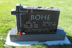
John Walter Rohe
| Birth | : | 12 Aug 1953 Carroll, Carroll County, Iowa, USA |
| Death | : | 15 Sep 2015 Templeton, Carroll County, Iowa, USA |
| Burial | : | Sacred Heart Cemetery, Templeton, Carroll County, USA |
| Coordinate | : | 41.9138746, -94.9460994 |
| Description | : | John Rohe, 62 of Templeton, died early Tuesday morning, September 15, 2015 at his residence near Templeton. Mass of the Christian Burial will be celebrated at 10:30 a.m. Friday, September 18, 2015 at Sacred Heart Catholic Church in Templeton. The Celebrant will be Fr. Steve Brodersen. Music will be Jeanne Kerkhoff and the Sacred Heart Men’s Choir. Burial will be in the parish cemetery. Friends may call at the Sharp Funeral Home in Carroll after 4 p.m. on Thursday where there will be a rosary at 5 p.m. by the Templeton Knights of Columbus and a Christian Wake... Read More |
frequently asked questions (FAQ):
-
Where is John Walter Rohe's memorial?
John Walter Rohe's memorial is located at: Sacred Heart Cemetery, Templeton, Carroll County, USA.
-
When did John Walter Rohe death?
John Walter Rohe death on 15 Sep 2015 in Templeton, Carroll County, Iowa, USA
-
Where are the coordinates of the John Walter Rohe's memorial?
Latitude: 41.9138746
Longitude: -94.9460994
Family Members:
Parent

Siblings
Flowers:


Nearby Cemetories:
1. Sacred Heart Cemetery
Templeton, Carroll County, USA
Coordinate: 41.9138746, -94.9460994
2. Elba Cemetery
Templeton, Carroll County, USA
Coordinate: 41.9068985, -94.9131012
3. Sacred Heart Cemetery
Manning, Carroll County, USA
Coordinate: 41.9132500, -95.0540000
4. Gray Cemetery
Gray, Audubon County, USA
Coordinate: 41.8414001, -94.9946976
5. Manning Cemetery
Manning, Carroll County, USA
Coordinate: 41.8990000, -95.0620000
6. Holy Angels Cemetery
Carroll County, USA
Coordinate: 42.0014000, -94.9141998
7. Cameron Cemetery
Audubon County, USA
Coordinate: 41.8236008, -94.9167023
8. Dedham Cemetery
Dedham, Carroll County, USA
Coordinate: 41.8993988, -94.8225021
9. Saint Josephs Cemetery
Dedham, Carroll County, USA
Coordinate: 41.8993988, -94.8210983
10. Saint Augustine Cemetery
Halbur, Carroll County, USA
Coordinate: 42.0066986, -94.9744034
11. Lincoln Township Cemetery
Gray, Audubon County, USA
Coordinate: 41.8198130, -95.0154970
12. Saint Marys Catholic Cemetery
Willey, Carroll County, USA
Coordinate: 41.9783363, -94.8212204
13. Iowa Township Cemetery
Aspinwall, Crawford County, USA
Coordinate: 41.9216995, -95.1113968
14. McCurdy Cemetery
Carroll County, USA
Coordinate: 41.9403000, -94.7649994
15. Viola Center Cemetery
Viola Center, Audubon County, USA
Coordinate: 41.8236008, -94.8016968
16. Old Carrollton Cemetery
Carrollton, Carroll County, USA
Coordinate: 41.9233017, -94.7403030
17. Mount Olivet Cemetery
Carroll, Carroll County, USA
Coordinate: 42.0536340, -94.8595510
18. Carroll City Cemetery
Carroll, Carroll County, USA
Coordinate: 42.0560963, -94.8599856
19. Hayes Township Cemetery
Westside, Crawford County, USA
Coordinate: 42.0083199, -95.1216583
20. Luccocks Grove Cemetery
Audubon County, USA
Coordinate: 41.7619019, -94.8653030
21. Douglas Township Cemetery
Audubon County, USA
Coordinate: 41.7611008, -95.0282974
22. Oak Hill Cemetery
Coon Rapids, Carroll County, USA
Coordinate: 41.9053001, -94.7200012
23. Westside Cemetery
Westside, Crawford County, USA
Coordinate: 42.0602989, -95.0922012
24. Saint Francis Cemetery
Maple River, Carroll County, USA
Coordinate: 42.0969009, -94.9372025