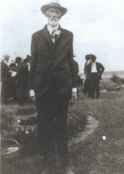
| Birth | : | 21 Dec 1847 Adair County, Missouri, USA |
| Death | : | 6 Nov 1907 Garfield County, Nebraska, USA |
| Burial | : | West Side Cemetery, Garfield County, USA |
| Coordinate | : | 41.8128014, -99.0282974 |
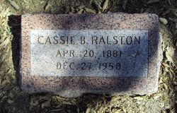
| Description | : | John was a Union soldier during the Civil War. He served in the 42nd Regiment, Company D, Missouri infantry. He and his wife Nancy Taylor raised eight children: William Erastus, Eliza, Celesta, Margaret Ann (Maggie), Loie, Alice Lorency (Laura),Cassie Bell & Leroy. |
frequently asked questions (FAQ):
-
Where is John Wesley Rice's memorial?
John Wesley Rice's memorial is located at: West Side Cemetery, Garfield County, USA.
-
When did John Wesley Rice death?
John Wesley Rice death on 6 Nov 1907 in Garfield County, Nebraska, USA
-
Where are the coordinates of the John Wesley Rice's memorial?
Latitude: 41.8128014
Longitude: -99.0282974
Family Members:
Parent
Spouse
Siblings
Children
Flowers:
Nearby Cemetories:
1. West Side Cemetery
Garfield County, USA
Coordinate: 41.8128014, -99.0282974
2. Potter Brown Cemetery
Burwell, Garfield County, USA
Coordinate: 41.7489000, -99.0668500
3. Banner Cemetery
Burwell, Garfield County, USA
Coordinate: 41.8031006, -99.1235962
4. Littlefield Cemetery
Burwell, Garfield County, USA
Coordinate: 41.8093987, -99.1389008
5. Fort Hartsuff Post Cemetery
Valley County, USA
Coordinate: 41.7225000, -99.0248000
6. Cottonwood Cemetery
Burwell, Garfield County, USA
Coordinate: 41.7681007, -99.1418991
7. Dry Cedar Cemetery
Garfield County, USA
Coordinate: 41.8202500, -98.8752500
8. Parker Cemetery
Burwell, Garfield County, USA
Coordinate: 41.8203011, -99.1821976
9. Jack Shafer Memorial Cemetery
Burwell, Garfield County, USA
Coordinate: 41.8202200, -99.1835500
10. Saint Marys Cemetery
Elyria, Valley County, USA
Coordinate: 41.6745000, -99.0015000
11. Elyria Cemetery
Elyria, Valley County, USA
Coordinate: 41.6692009, -99.0042038
12. Boleszyn Cemetery
Elyria, Valley County, USA
Coordinate: 41.6691000, -99.1315000
13. Bohemian Brotherhood Cemetery
Elyria, Valley County, USA
Coordinate: 41.6618996, -99.1866989
14. Ord Cemetery
Ord, Valley County, USA
Coordinate: 41.6142006, -98.9403000
15. Czech National Cemetery
Valley County, USA
Coordinate: 41.6250000, -99.1537000
16. Erina Cemetery
Garfield County, USA
Coordinate: 42.0010000, -98.8916000
17. Saint Wenceslaus Catholic Cemetery
Valley County, USA
Coordinate: 41.6103000, -99.1336000
18. Kent Cemetery
Taylor, Loup County, USA
Coordinate: 41.7416992, -99.3088989
19. Amity Cemetery
Greeley County, USA
Coordinate: 41.7158012, -98.7322006
20. Springdale Hillside Cemetery
Valley County, USA
Coordinate: 41.6114010, -98.8282950
21. Manderson Cemetery
Valley County, USA
Coordinate: 41.5598870, -99.0949250
22. Longwood Cemetery
Comstock, Custer County, USA
Coordinate: 41.5966988, -99.2356033
23. Vinton Cemetery
Ord, Valley County, USA
Coordinate: 41.5467000, -98.9970000
24. Taylor Cemetery
Taylor, Loup County, USA
Coordinate: 41.7571983, -99.3861008


