

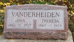
John William Vanderheiden
| Birth | : | 11 Sep 1861 De Pere, Brown County, Wisconsin, USA |
| Death | : | 26 May 1937 Carroll, Carroll County, Iowa, USA |
| Burial | : | Forest Hill Cemetery, Maryville, Blount County, USA |
| Coordinate | : | 35.7052994, -83.9674988 |
| Description | : | *** IN LOVING MEMORY OF *** John William5 Vanderheiden was born on Wednesday; September 11, 1861 in De Pere; Brown County, Wisconsin. He was the son of Lambert and Maria Magdalena (Vinkenvleugel) Vanderheiden. He passed away on: Wednesday; May 26, 1937 in Carroll; Carroll County, Iowa. He was buried at Mount Olivet Cemetery at Carroll, Iowa. He married Theresa Helen Ricke 07 January 1892 in Breda; Carroll County, Iowa. She was the daughter of: Richard Ricke and Mary Fleege. She was born 15 April 1865 in Galena, Jo Daviess County, Illinois, and died 30 July 1923. ... Read More |
frequently asked questions (FAQ):
-
Where is John William Vanderheiden's memorial?
John William Vanderheiden's memorial is located at: Forest Hill Cemetery, Maryville, Blount County, USA.
-
When did John William Vanderheiden death?
John William Vanderheiden death on 26 May 1937 in Carroll, Carroll County, Iowa, USA
-
Where are the coordinates of the John William Vanderheiden's memorial?
Latitude: 35.7052994
Longitude: -83.9674988
Family Members:
Parent
Spouse
Siblings
Children
Flowers:


Nearby Cemetories:
1. Forest Hill Cemetery
Maryville, Blount County, USA
Coordinate: 35.7052994, -83.9674988
2. Long Crooked Creek Family Cemetery
Maryville, Blount County, USA
Coordinate: 35.7071700, -83.9617900
3. Cupp Simerly Cemetery
Maryville, Blount County, USA
Coordinate: 35.7136002, -83.9432983
4. Saint Paul Evangelical Lutheran Church Columbarium
Maryville, Blount County, USA
Coordinate: 35.7259800, -83.9917900
5. Faith Encounter Church Cemetery
Maryville, Blount County, USA
Coordinate: 35.7265520, -83.9432290
6. Saint Johns Lutheran Cemetery
Blount County, USA
Coordinate: 35.7233009, -83.9383011
7. Old Piney Grove Cemetery
Blount County, USA
Coordinate: 35.6856003, -83.9328003
8. Russell Family Cemetery
Blount County, USA
Coordinate: 35.7112400, -83.9257400
9. Hamil Cemetery
Maryville, Blount County, USA
Coordinate: 35.6884110, -84.0051150
10. Liberty Christian Church Cemetery
Montvale, Blount County, USA
Coordinate: 35.6681300, -83.9657700
11. Pecks Chapel Cemetery
Maryville, Blount County, USA
Coordinate: 35.7336006, -83.9375000
12. Maple Grove Missionary Baptist Church Cemetery
Maryville, Blount County, USA
Coordinate: 35.6853680, -84.0066150
13. Six Mile Cemetery
Blount County, USA
Coordinate: 35.6643982, -83.9574966
14. Pleasant Hill Cemetery
Maryville, Blount County, USA
Coordinate: 35.7355995, -83.9317017
15. Chilhowee View Cemetery
Maryville, Blount County, USA
Coordinate: 35.7356186, -83.9314194
16. Carpenters Campground Cemetery
Maryville, Blount County, USA
Coordinate: 35.6719017, -84.0008011
17. College Cemetery
Maryville, Blount County, USA
Coordinate: 35.7493600, -83.9607400
18. Magnolia Cemetery
Maryville, Blount County, USA
Coordinate: 35.7503014, -83.9705963
19. Russell Cemetery
Blount County, USA
Coordinate: 35.7164200, -83.9129600
20. Old Quaker Cemetery
Blount County, USA
Coordinate: 35.7516600, -83.9813200
21. McGinley Cemetery
Blount County, USA
Coordinate: 35.7243996, -83.9131012
22. New Providence Cemetery
Maryville, Blount County, USA
Coordinate: 35.7532997, -83.9728012
23. Maple Grove Cemetery
Maryville, Blount County, USA
Coordinate: 35.7514153, -83.9898529
24. Fellowship Baptist Cemetery
Maryville, Blount County, USA
Coordinate: 35.7472000, -84.0017014