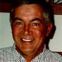
Joseph Thomas “Joe” Pitzenberger
| Birth | : | 21 Oct 1953 Mason City, Cerro Gordo County, Iowa, USA |
| Death | : | 25 Oct 2012 Mason City, Cerro Gordo County, Iowa, USA |
| Burial | : | Owens Grove Cemetery, Cerro Gordo County, USA |
| Coordinate | : | 43.0825005, -93.1144180 |
| Description | : | Joseph "Joe" T. Pitzenberger, 59, Mason City died Thursday, October 25, 2012 at Mercy Medical Center. A memorial Mass for Joe will be held 10:30am, Monday, October 29, 2012 at St. Joseph Catholic Church, 302 5th St. SE, Mason City with the Reverend Rodney M. Allers as celebrant. A visitation will be held from 4 to 7pm, Sunday, October 28, 2012 at Hogan Bremer Moore Colonial Chapel, 126 3rd St. NE, Mason City with a KC Rosary beginning at 6:30pm. Should friends desire, memorial contributions may be designated to Hospice of North Iowa or the Newman Catholic High School in... Read More |
frequently asked questions (FAQ):
-
Where is Joseph Thomas “Joe” Pitzenberger's memorial?
Joseph Thomas “Joe” Pitzenberger's memorial is located at: Owens Grove Cemetery, Cerro Gordo County, USA.
-
When did Joseph Thomas “Joe” Pitzenberger death?
Joseph Thomas “Joe” Pitzenberger death on 25 Oct 2012 in Mason City, Cerro Gordo County, Iowa, USA
-
Where are the coordinates of the Joseph Thomas “Joe” Pitzenberger's memorial?
Latitude: 43.0825005
Longitude: -93.1144180
Family Members:
Parent
Spouse
Siblings
Nearby Cemetories:
1. Elmwood Saint Joseph Cemetery
Mason City, Cerro Gordo County, USA
Coordinate: 43.1399994, -93.2067032
2. IOOF Cemetery
Mason City, Cerro Gordo County, USA
Coordinate: 43.1336975, -93.2139130
3. Saint Johns Episcopal Church Columbarium
Mason City, Cerro Gordo County, USA
Coordinate: 43.1528900, -93.1980730
4. First Congregational UCC Columbarium
Mason City, Cerro Gordo County, USA
Coordinate: 43.1529720, -93.1990410
5. Rock Grove Township Cemetery
Nora Springs, Floyd County, USA
Coordinate: 43.1227989, -92.9880981
6. Park Cemetery
Nora Springs, Floyd County, USA
Coordinate: 43.1444016, -92.9982986
7. Spring Grove Cemetery
Nora Springs, Floyd County, USA
Coordinate: 43.1631012, -93.0211029
8. Rockwell Cemetery
Rockwell, Cerro Gordo County, USA
Coordinate: 42.9786000, -93.1919000
9. Riverside Cemetery
Rockford, Floyd County, USA
Coordinate: 43.0578003, -92.9464035
10. Rock Falls Cemetery
Rock Falls, Cerro Gordo County, USA
Coordinate: 43.2122192, -93.0858307
11. Sacred Heart Cemetery
Rockwell, Cerro Gordo County, USA
Coordinate: 42.9592018, -93.1913986
12. Memorial Park Cemetery
Mason City, Cerro Gordo County, USA
Coordinate: 43.1469002, -93.2936020
13. Rudd Evergreen Cemetery
Rudd, Floyd County, USA
Coordinate: 43.1417007, -92.9214020
14. Mount Vernon Cemetery
Mount Vernon Township, Cerro Gordo County, USA
Coordinate: 43.0374985, -93.3181000
15. Ulsterville Cemetery
Ulster Township, Floyd County, USA
Coordinate: 43.0936012, -92.8842010
16. Bohemian Cemetery
Plymouth, Cerro Gordo County, USA
Coordinate: 43.2522011, -93.1252975
17. Saint Patricks Catholic Cemetery
Dougherty, Cerro Gordo County, USA
Coordinate: 42.9227791, -93.0294418
18. Oakwood Cemetery
Plymouth, Cerro Gordo County, USA
Coordinate: 43.2538986, -93.1252975
19. Saint John Zion Cemetery
Sheffield, Franklin County, USA
Coordinate: 42.8969002, -93.1472015
20. West Fork Cemetery
Franklin County, USA
Coordinate: 42.8918991, -93.0836029
21. Hillside Cemetery
Sheffield, Franklin County, USA
Coordinate: 42.9006004, -93.2007980
22. Clear Lake Cemetery
Clear Lake, Cerro Gordo County, USA
Coordinate: 43.1422195, -93.3658295
23. Flood Creek Cemetery
Floyd County, USA
Coordinate: 43.0391998, -92.8538971
24. West End Cemetery
Meroa, Mitchell County, USA
Coordinate: 43.2216682, -92.9250031


