
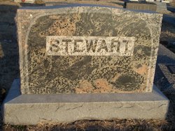
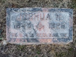
Joshua N Stewart
| Birth | : | 10 Mar 1845 Greene County, Missouri, USA |
| Death | : | 6 Apr 1928 Parsons, Labette County, Kansas, USA |
| Burial | : | Aspen Grove Cemetery, Burlington, Des Moines County, USA |
| Coordinate | : | 40.8269005, -91.1194000 |
| Plot | : | Section 8 Lot 40 Space 3 |
| Inscription | : | Co D 4th Regt Ks Inf |
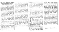
| Description | : | When he was about ten years of age the family moved to Bourbon County, Kansas near Fort Scott. The family suffered the raids of the border ruffians, and knew what war was long before the nation plunged into war. He grew to manhood in that vicinity, and at the beginning of the Civil War he enlisted in Company D., Fourth Regiment Kansas Infantry. He was mustered our in 1862, and during the rest of the war, he drove a government wagon with supplies from Fort Scott to Fort Gibson in the southwest corner of Missouri. The trail he followed was... Read More |
frequently asked questions (FAQ):
-
Where is Joshua N Stewart's memorial?
Joshua N Stewart's memorial is located at: Aspen Grove Cemetery, Burlington, Des Moines County, USA.
-
When did Joshua N Stewart death?
Joshua N Stewart death on 6 Apr 1928 in Parsons, Labette County, Kansas, USA
-
Where are the coordinates of the Joshua N Stewart's memorial?
Latitude: 40.8269005
Longitude: -91.1194000
Family Members:
Spouse

Children
Flowers:


Nearby Cemetories:
1. Aspen Grove Cemetery
Burlington, Des Moines County, USA
Coordinate: 40.8269005, -91.1194000
2. Burlington Jewish Cemetery
West Burlington, Des Moines County, USA
Coordinate: 40.8217000, -91.1311000
3. North Sixth Street Cemetery
Burlington, Des Moines County, USA
Coordinate: 40.8205986, -91.1022034
4. Burlington Memorial Park
Burlington, Des Moines County, USA
Coordinate: 40.8417000, -91.1514000
5. Wykert Cemetery
Burlington, Des Moines County, USA
Coordinate: 40.8580000, -91.1336000
6. Saint Marys Catholic Cemetery
West Burlington, Des Moines County, USA
Coordinate: 40.8240738, -91.1691437
7. Meyers Family Plot
Burlington, Des Moines County, USA
Coordinate: 40.8658000, -91.1185000
8. Steingreaber Cemetery
Burlington, Des Moines County, USA
Coordinate: 40.8668300, -91.1257600
9. Flint River Township Cemetery
Des Moines County, USA
Coordinate: 40.8655000, -91.1540000
10. Greenwood Cemetery
West Burlington, Des Moines County, USA
Coordinate: 40.8367004, -91.1838989
11. Walden Family Cemetery
Des Moines County, USA
Coordinate: 40.8778155, -91.1265352
12. Chief Taimah Memorial Site
Burlington, Des Moines County, USA
Coordinate: 40.8755935, -91.0918120
13. Sacred Heart Cemetery
Burlington, Des Moines County, USA
Coordinate: 40.7733002, -91.0991974
14. Spring Creek Cemetery
West Burlington, Des Moines County, USA
Coordinate: 40.7980995, -91.1892014
15. Inghram Cemetery
Des Moines County, USA
Coordinate: 40.8406000, -91.1996000
16. Johnson Cemetery
Des Moines County, USA
Coordinate: 40.8231000, -91.2021000
17. Old County Home Cemetery
Des Moines County, USA
Coordinate: 40.8043800, -91.2040500
18. Prugh Farm Plot
Burlington, Des Moines County, USA
Coordinate: 40.7583730, -91.1140340
19. Porter Cemetery
Burlington, Des Moines County, USA
Coordinate: 40.7693000, -91.1702000
20. Swede Cemetery
Burlington, Des Moines County, USA
Coordinate: 40.7756000, -91.1836000
21. Cowles Farm Plots
Burlington, Des Moines County, USA
Coordinate: 40.7551000, -91.1093000
22. North Walker Cemetery
Des Moines County, USA
Coordinate: 40.8993988, -91.1057968
23. Latty Church Cemetery
Burlington, Des Moines County, USA
Coordinate: 40.9030000, -91.1220000
24. Walker Family Plot
Burlington, Des Moines County, USA
Coordinate: 40.8892700, -91.1779200