Josiah J. “Joe” Fowler
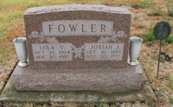
| Birth | : | 10 Oct 1899 Rushville, Buchanan County, Missouri, USA |
| Death | : | 20 May 1977 Moran, Allen County, Kansas, USA |
| Burial | : | Forest Lawn Cemetery, Ruidoso, Lincoln County, USA |
| Coordinate | : | 33.3567009, -105.6688995 |
| Plot | : | North Section, Block 7, Row 2, Lot 12, Plot 2 |
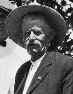
| Description | : | The Chanute Tribune (May 23, 1977): Moran - Josiah "Joe" Fowler, 77, born in Rushville, Mo., died unexpectedly at his home Friday. Cause of death has not been determined. District commander of 5B World War Barracks, he was elected senior vice commander of the State World War I Department at the state convention this month. A veteran of World War I, serving in the Coast Artillery, he was a member of World War I, Barracks 162, Moran, and La Harpe Veterans of Foreign Wars, as well as Moran Ruritan and Marmaton Masonic Lodge 245. He was civil service personnel director for the city... Read More |
frequently asked questions (FAQ):
-
Where is Josiah J. “Joe” Fowler's memorial?
Josiah J. “Joe” Fowler's memorial is located at: Forest Lawn Cemetery, Ruidoso, Lincoln County, USA.
-
When did Josiah J. “Joe” Fowler death?
Josiah J. “Joe” Fowler death on 20 May 1977 in Moran, Allen County, Kansas, USA
-
Where are the coordinates of the Josiah J. “Joe” Fowler's memorial?
Latitude: 33.3567009
Longitude: -105.6688995
Family Members:
Parent
Spouse
Siblings
Flowers:
Nearby Cemetories:
1. Forest Lawn Cemetery
Ruidoso, Lincoln County, USA
Coordinate: 33.3567009, -105.6688995
2. First Christian Church Memorial Prayer Garden
Ruidoso, Lincoln County, USA
Coordinate: 33.3728390, -105.6490780
3. Gavilan Memorial Gardens Cemetery
Ruidoso, Lincoln County, USA
Coordinate: 33.3667820, -105.6438250
4. Holy Mount Episcopal Church Columbarium
Ruidoso, Lincoln County, USA
Coordinate: 33.3206980, -105.6335340
5. West-Box Cemetery
Bonito, Lincoln County, USA
Coordinate: 33.4253000, -105.6130000
6. Angus Cemetery
Alto, Lincoln County, USA
Coordinate: 33.4447250, -105.6652520
7. Church of the Nazarene Cemetery
Lincoln County, USA
Coordinate: 33.4459980, -105.6627650
8. Stetson Cemetery
Ruidoso Downs, Lincoln County, USA
Coordinate: 33.3525009, -105.5560989
9. Ruidoso-Hondo Valley Memorial Park
Ruidoso Downs, Lincoln County, USA
Coordinate: 33.3675100, -105.5357500
10. San Ysidro Mission Church Cemetery
Glencoe, Lincoln County, USA
Coordinate: 33.3796000, -105.5096000
11. Whitetail Cemetery
Whitetail, Otero County, USA
Coordinate: 33.2172012, -105.5725021
12. La Gloria Cemetery
Capitan, Lincoln County, USA
Coordinate: 33.5152020, -105.5827030
13. Gonzales Family Cemetery
Glencoe, Lincoln County, USA
Coordinate: 33.4020510, -105.4648090
14. Fort Stanton Cemetery
Fort Stanton, Lincoln County, USA
Coordinate: 33.4875790, -105.5256470
15. Fort Stanton Merchant Marine & Military Cemetery
Fort Stanton, Lincoln County, USA
Coordinate: 33.4901000, -105.5154500
16. Fort Stanton State Veterans Cemetery
Fort Stanton, Lincoln County, USA
Coordinate: 33.4915518, -105.5135259
17. George Coe Cemetery
Glencoe, Lincoln County, USA
Coordinate: 33.4077988, -105.4468994
18. Smokey Bear Historical Park
Capitan, Lincoln County, USA
Coordinate: 33.5459000, -105.5739000
19. Capitan Cemetery
Capitan, Lincoln County, USA
Coordinate: 33.5468310, -105.5725190
20. Saint Joseph Apache Mission Churchyard
Mescalero, Otero County, USA
Coordinate: 33.1548850, -105.7674670
21. Nogal Cemetery
Nogal, Lincoln County, USA
Coordinate: 33.5758018, -105.7136002
22. Blazer Cemetery
Mescalero, Otero County, USA
Coordinate: 33.1567612, -105.7859573
23. Mescalero Indian Cemetery
Mescalero, Otero County, USA
Coordinate: 33.1474991, -105.7755966
24. Aldaz-Baca Family Cemetery
Lincoln, Lincoln County, USA
Coordinate: 33.5242960, -105.4601270

