
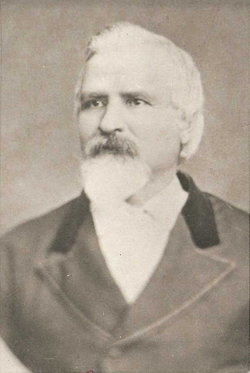

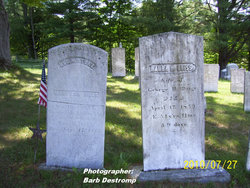
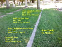
Judge Eli Todd Stone
| Birth | : | 16 Jun 1829 Cabot, Washington County, Vermont, USA |
| Death | : | 14 Mar 1887 Modesto, Stanislaus County, California, USA |
| Burial | : | Modesto Pioneer Cemetery, Modesto, Stanislaus County, USA |
| Coordinate | : | 37.6473350, -120.9829040 |
| Plot | : | Block 32 Lot 1 Grave 3 |
| Description | : | #43900458: His father's name was George Washington Stone (birth 4 Oct 1806 in Cabot, Washington, Vermont). He died in Modesto on 17 Nov 1888, but not sure where he is buried, maybe in Vermont, he is on his wife's marker but no death info, so I am thinking if they shipped him to Vermont I would have thought they would have put his death info on the marker. _______________ Eli Todd Stone married Anna Aldruda Reed in Knights Ferry, CA on August 14, 1859. I am unsure of where the following children were buried: "Stone" 12/7/1860 - 12/8/1860 Edward Chester Stone 9/13/1862 - 6/1/1864 Josephine A... Read More |
frequently asked questions (FAQ):
-
Where is Judge Eli Todd Stone's memorial?
Judge Eli Todd Stone's memorial is located at: Modesto Pioneer Cemetery, Modesto, Stanislaus County, USA.
-
When did Judge Eli Todd Stone death?
Judge Eli Todd Stone death on 14 Mar 1887 in Modesto, Stanislaus County, California, USA
-
Where are the coordinates of the Judge Eli Todd Stone's memorial?
Latitude: 37.6473350
Longitude: -120.9829040
Family Members:
Parent
Spouse
Children

Flowers:


Nearby Cemetories:
1. Modesto Pioneer Cemetery
Modesto, Stanislaus County, USA
Coordinate: 37.6473350, -120.9829040
2. Acacia Memorial Park
Modesto, Stanislaus County, USA
Coordinate: 37.6481080, -120.9836610
3. Modesto Citizens Cemetery
Modesto, Stanislaus County, USA
Coordinate: 37.6472930, -120.9845570
4. Saint Stanislaus Catholic Cemetery
Modesto, Stanislaus County, USA
Coordinate: 37.6473610, -120.9808440
5. Modesto County Cemetery
Modesto, Stanislaus County, USA
Coordinate: 37.6492400, -120.9813800
6. Ceres Memorial Park
Ceres, Stanislaus County, USA
Coordinate: 37.5958214, -120.9634399
7. Lakewood Memorial Park
Hughson, Stanislaus County, USA
Coordinate: 37.6199760, -120.8975983
8. Good Shepherd Catholic Cemetery
Modesto, Stanislaus County, USA
Coordinate: 37.6853130, -121.0672890
9. Wood Colony Cemetery
Salida, Stanislaus County, USA
Coordinate: 37.6893730, -121.0682144
10. Burwood Cemetery
Escalon, San Joaquin County, USA
Coordinate: 37.7616997, -120.9593964
11. Langworth Cemetery
Oakdale, Stanislaus County, USA
Coordinate: 37.7580986, -120.8957977
12. Ripon Cemetery
Ripon, San Joaquin County, USA
Coordinate: 37.7420311, -121.1238708
13. Oakdale Citizens Cemetery
Oakdale, Stanislaus County, USA
Coordinate: 37.7624600, -120.8388800
14. Oaklawn Memorial Park
Oakdale, Stanislaus County, USA
Coordinate: 37.7711945, -120.8486862
15. Saint John's Catholic Cemetery
Escalon, San Joaquin County, USA
Coordinate: 37.7994537, -121.0705185
16. Denair Cemetery
Denair, Stanislaus County, USA
Coordinate: 37.5293999, -120.8199997
17. Martin Cemetery
Waterford, Stanislaus County, USA
Coordinate: 37.6684360, -120.7582160
18. Turlock Memorial Park
Turlock, Stanislaus County, USA
Coordinate: 37.4937592, -120.8659821
19. Grayson Cemetery
Grayson, Stanislaus County, USA
Coordinate: 37.5594559, -121.1802826
20. Valley Home Memorial Park
Oakdale, Stanislaus County, USA
Coordinate: 37.8275528, -120.9333267
21. Saint Francis Episcopal Church Columbarium
Turlock, Stanislaus County, USA
Coordinate: 37.5014300, -120.8368400
22. Patterson District Cemetery
Patterson, Stanislaus County, USA
Coordinate: 37.5268135, -121.1728287
23. Atlanta Cemetery
Five Corners, San Joaquin County, USA
Coordinate: 37.8270035, -121.1420135
24. North Hilmar Cemetery
Hilmar, Merced County, USA
Coordinate: 37.4146614, -120.8864288