
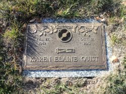
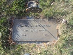
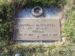
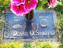
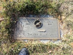
Karen Elaine Stouffer Quist
| Birth | : | 27 Feb 1942 Spencer, Clay County, Iowa, USA |
| Death | : | 12 Oct 2013 Spencer, Clay County, Iowa, USA |
| Burial | : | North Lawn Cemetery, Spencer, Clay County, USA |
| Coordinate | : | 43.1600000, -95.1470000 |
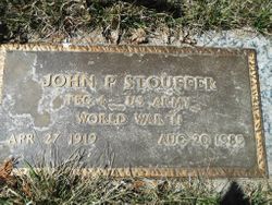
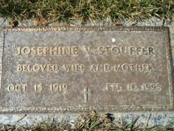
| Description | : | Karen Quist passed away Saturday,October 12 at Beehive Homes Assisted Living in Spencer. Karen Elaine Quist, the daughter of John P and Josephine Maurer Stouffer, was born February 27, 1942 in Spencer. Her early education was received in Spencer and graduated in 1960 from the Spencer High School. Karen married Marvin Blaine Quist on June 21, 1960, in Glenwood, MN. They lived in Brooten, MN until moving to Spencer in 1966. In 1972, they moved to Gillett Grove where she worked as a janitor for Gillett Grove Schools for three years. Karen then worked at several nursing homes for 25 years... Read More |
frequently asked questions (FAQ):
-
Where is Karen Elaine Stouffer Quist's memorial?
Karen Elaine Stouffer Quist's memorial is located at: North Lawn Cemetery, Spencer, Clay County, USA.
-
When did Karen Elaine Stouffer Quist death?
Karen Elaine Stouffer Quist death on 12 Oct 2013 in Spencer, Clay County, Iowa, USA
-
Where are the coordinates of the Karen Elaine Stouffer Quist's memorial?
Latitude: 43.1600000
Longitude: -95.1470000
Family Members:
Parent
Spouse
Siblings
Children
Flowers:


Nearby Cemetories:
1. North Lawn Cemetery
Spencer, Clay County, USA
Coordinate: 43.1600000, -95.1470000
2. Dewey Readmore Books Memorial
Spencer, Clay County, USA
Coordinate: 43.1403999, -95.1443024
3. Riverside Cemetery
Spencer, Clay County, USA
Coordinate: 43.1441994, -95.1671982
4. Fairview Cemetery
Clay County, USA
Coordinate: 43.1899986, -95.0800018
5. Evergreen Cemetery
Clay County, USA
Coordinate: 43.2052994, -95.2086029
6. Dickens Cemetery
Dickens, Clay County, USA
Coordinate: 43.1280000, -95.0155000
7. Swedish Lutheran Cemetery
Royal, Clay County, USA
Coordinate: 43.0683000, -95.2350000
8. Little Sioux Lutheran Cemetery
Milford, Dickinson County, USA
Coordinate: 43.2702065, -95.2109528
9. Rosehill Cemetery
Clay County, USA
Coordinate: 43.0368996, -95.0919037
10. First Reformed Cemetery
Clay County, USA
Coordinate: 43.2399500, -95.2889000
11. Lone Tree Cemetery
Everly, Clay County, USA
Coordinate: 43.1411018, -95.3347015
12. Milford Cemetery
Milford, Dickinson County, USA
Coordinate: 43.3092003, -95.1481018
13. Lincoln Cemetery
Rossie, Clay County, USA
Coordinate: 43.0111008, -95.2313995
14. Calvary Cemetery
Milford, Dickinson County, USA
Coordinate: 43.3213997, -95.1688995
15. Logan Township Cemetery
Clay County, USA
Coordinate: 43.0489006, -94.9747009
16. Liberty Cemetery
Greenville, Clay County, USA
Coordinate: 42.9897003, -95.1417007
17. Willow Creek Cemetery
Royal, Clay County, USA
Coordinate: 43.0214005, -95.2885971
18. Clay Center Cemetery
Royal, Clay County, USA
Coordinate: 43.0410995, -95.3272018
19. TriMello Cemetery
Royal, Clay County, USA
Coordinate: 43.0682983, -95.3728027
20. Crown Hill Cemetery
Ruthven, Palo Alto County, USA
Coordinate: 43.1328011, -94.8878021
21. Calvary Cemetery
Ruthven, Palo Alto County, USA
Coordinate: 43.1314011, -94.8869019
22. Zion Methodist Cemetery
Clay County, USA
Coordinate: 42.9808006, -95.2497025
23. Westport Cemetery
Dickinson County, USA
Coordinate: 43.3130989, -95.3289032
24. Okoboji Cemetery
Arnolds Park, Dickinson County, USA
Coordinate: 43.3649406, -95.1303558