
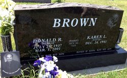
Karen L. Davis Brown
| Birth | : | 24 Dec 1941 Scandia, Republic County, Kansas, USA |
| Death | : | 6 Feb 2015 Concordia, Cloud County, Kansas, USA |
| Burial | : | Brown Cemetery, Donegal Township, Westmoreland County, USA |
| Coordinate | : | 40.1016998, -79.4064026 |
| Description | : | Married July 30, 1966 Mother of Donny, Alan and Judy Karen L. Brown, age 73, died Friday, Feb. 6, 2015 at her home in Concordia, KS. She was born on Dec. 24, 1941 in Scandia, KS to Lauren “Hap” & Julia (Flesher) Davis. Karen graduated from Scandia High School. She married Donald “Donnie” R. Brown on July 30, 1966. He preceded her in death on March 1, 2001. She was a cook for the Sisters of St. Joseph at the Nazareth Motherhouse & Manna House. She was a member of Our Lady of Perpetual Help Catholic Church and Altar Society. She is survived by... Read More |
frequently asked questions (FAQ):
-
Where is Karen L. Davis Brown's memorial?
Karen L. Davis Brown's memorial is located at: Brown Cemetery, Donegal Township, Westmoreland County, USA.
-
When did Karen L. Davis Brown death?
Karen L. Davis Brown death on 6 Feb 2015 in Concordia, Cloud County, Kansas, USA
-
Where are the coordinates of the Karen L. Davis Brown's memorial?
Latitude: 40.1016998
Longitude: -79.4064026
Family Members:
Parent

Spouse

Flowers:


Nearby Cemetories:
1. Brown Cemetery
Donegal Township, Westmoreland County, USA
Coordinate: 40.1016998, -79.4064026
2. Keslar Cemetery
Fayette County, USA
Coordinate: 40.0995100, -79.4145100
3. Donegal Cemetery
Donegal, Westmoreland County, USA
Coordinate: 40.1112000, -79.3785000
4. Hays Cemetery
Mount Pleasant, Westmoreland County, USA
Coordinate: 40.1259000, -79.4021000
5. Walnut Hill Cemetery
Donegal, Westmoreland County, USA
Coordinate: 40.1040000, -79.3659000
6. Eutsey Cemetery Old
Fayette County, USA
Coordinate: 40.0781400, -79.4427900
7. Porch Cemetery
Donegal, Westmoreland County, USA
Coordinate: 40.1306000, -79.3711014
8. Byerly Freeman Cemetery
Mount Pleasant, Westmoreland County, USA
Coordinate: 40.1432500, -79.4100900
9. Eutsey Cemetery
Fayette County, USA
Coordinate: 40.0742400, -79.4474900
10. Melcroft Cemetery
Fayette County, USA
Coordinate: 40.0561000, -79.3829000
11. Knopsnider Cemetery New
Bullskin Township, Fayette County, USA
Coordinate: 40.0685400, -79.4686800
12. Knopsnider Cemetery (Old)
Bullskin Township, Fayette County, USA
Coordinate: 40.0691400, -79.4704800
13. Stouffer Cemetery
Bullskin Township, Fayette County, USA
Coordinate: 40.0848990, -79.4816900
14. Saint Raymonds Cemetery
Melcroft, Fayette County, USA
Coordinate: 40.0572014, -79.3531036
15. Mount Nebo Cemetery
Indian Head, Fayette County, USA
Coordinate: 40.0531000, -79.3556000
16. Dan Snyder Cemetery
Fayette County, USA
Coordinate: 40.0408000, -79.4317000
17. Mellinger Cemetery
Mellingertown, Westmoreland County, USA
Coordinate: 40.1432050, -79.4784730
18. Nicholson Cemetery
Clinton, Fayette County, USA
Coordinate: 40.0506100, -79.4745600
19. Good Hope Lutheran Cemetery
Fayette County, USA
Coordinate: 40.0282000, -79.3893900
20. Lobingier Cemetery
Mount Pleasant Township, Westmoreland County, USA
Coordinate: 40.1439030, -79.4887870
21. Franklin Lutheran Cemetery
Kregar, Westmoreland County, USA
Coordinate: 40.1215000, -79.3085000
22. Sparks Cemetery
Indian Head, Fayette County, USA
Coordinate: 40.0239200, -79.3892500
23. Brothers Cemetery
Fayette County, USA
Coordinate: 40.1360700, -79.5004300
24. Fairview Cemetery
Kecksburg, Westmoreland County, USA
Coordinate: 40.1696000, -79.4634000