
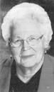
Karen Marie Edeal Kander
| Birth | : | 12 May 1941 Overton, Dawson County, Nebraska, USA |
| Death | : | 15 Feb 2015 Stanton, Stanton County, Nebraska, USA |
| Burial | : | Stanton Cemetery, Stanton, Stanton County, USA |
| Coordinate | : | 41.9599991, -97.2121964 |
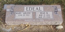
| Description | : | Karen Marie (Edeal) Kander, age 73, lost her battle with cancer at her home in Stanton, surrounded by family on Sunday, Feb. 15, 2015. Her love for Christ resonated throughout her life. Services were held Feb. 17 at the St. John’s Lutheran Church in Stanton. She was born on May 12, 1941 in Overton, to Dean and Arlene (Pullen) Edeal. Karen graduated eighth grade from District No. 21. In her high school years at Lexington High School, Karen excelled in school activities and 4-H, earning trips to Chicago, Kansas City, and Washington, D.C. Karen... Read More |
frequently asked questions (FAQ):
-
Where is Karen Marie Edeal Kander's memorial?
Karen Marie Edeal Kander's memorial is located at: Stanton Cemetery, Stanton, Stanton County, USA.
-
When did Karen Marie Edeal Kander death?
Karen Marie Edeal Kander death on 15 Feb 2015 in Stanton, Stanton County, Nebraska, USA
-
Where are the coordinates of the Karen Marie Edeal Kander's memorial?
Latitude: 41.9599991
Longitude: -97.2121964
Family Members:
Parent

Flowers:


Nearby Cemetories:
1. Stanton Cemetery
Stanton, Stanton County, USA
Coordinate: 41.9599991, -97.2121964
2. Zilmer Cemetery
Stanton, Stanton County, USA
Coordinate: 41.9464000, -97.2528000
3. Belz Cemetery
Stanton, Stanton County, USA
Coordinate: 41.9528008, -97.2619019
4. Koch Cemetery
Stanton County, USA
Coordinate: 41.9855995, -97.1731033
5. Zander Cemetery
Stanton County, USA
Coordinate: 41.9888992, -97.1750031
6. Hoosier Hollow Pioneer Cemetery
Stanton County, USA
Coordinate: 41.9900017, -97.2814026
7. Elkhorn Cemetery
Pilger, Stanton County, USA
Coordinate: 41.9899910, -97.1316720
8. Norwegian Cemetery
Stanton, Stanton County, USA
Coordinate: 41.9171600, -97.2907160
9. Bethlehem Cemetery
Stanton County, USA
Coordinate: 42.0332985, -97.2241974
10. Kuehn Cemetery
Pilger, Stanton County, USA
Coordinate: 41.9682000, -97.1049000
11. Erychleb Cemetery
Stanton County, USA
Coordinate: 41.8664017, -97.2138977
12. Bega Cemetery
Stanton County, USA
Coordinate: 42.0736008, -97.2343979
13. Muller Cemetery
Pilger, Stanton County, USA
Coordinate: 42.0780940, -97.1781920
14. Schwedt Cemetery
Pilger, Stanton County, USA
Coordinate: 41.9240000, -97.0480000
15. Pilger Cemetery
Pilger, Stanton County, USA
Coordinate: 42.0217018, -97.0591965
16. Zion Cemetery
Stanton County, USA
Coordinate: 42.0421982, -97.3638992
17. Christ Lutheran Cemetery
Stanton County, USA
Coordinate: 42.0433006, -97.3636017
18. Norfolk State Hospital New Cemetery
Norfolk, Madison County, USA
Coordinate: 42.0475500, -97.3698300
19. Spring Branch Cemetery
Spring Branch Township, Stanton County, USA
Coordinate: 42.0789400, -97.3297400
20. Saint Matthews Lutheran Cemetery
Wisner, Cuming County, USA
Coordinate: 41.9175000, -97.0189000
21. Norfolk State Hospital Old Cemetery
Norfolk, Madison County, USA
Coordinate: 42.0535400, -97.3733100
22. Pleasant Valley Cemetery
Madison County, USA
Coordinate: 41.8877983, -97.3972015
23. E U B Cemetery
Hoskins, Wayne County, USA
Coordinate: 42.1137900, -97.3015700
24. Trinity Cemetery
Hoskins, Wayne County, USA
Coordinate: 42.1055984, -97.3274994