
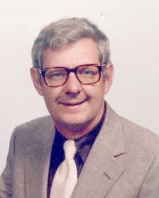
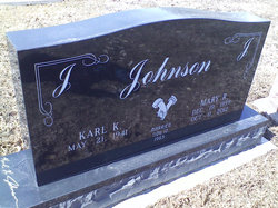
Karl Kent Johnson
| Birth | : | 21 May 1941 Clay County, Indiana, USA |
| Death | : | 8 Oct 2017 Terre Haute, Vigo County, Indiana, USA |
| Burial | : | Lebanon Cemetery, Midland, Greene County, USA |
| Coordinate | : | 39.1252823, -87.1857224 |
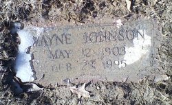
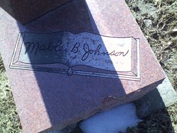
| Description | : | Karl K. Johnson Monday, October 9, 2017 Karl Kent Johnson, 76, of Jasonville, passed away at 2:13 p.m. Sunday, October 8, 2017 at Regional Hospital in Terre Haute. He was born May 21, 1941 in Clay County to Wayne Johnson and Mable B. (Kent) Johnson. Karl married Mary Ruth (Swalls) Johnson on Nov. 12, 1965 and she passed away on Oct. 11, 2012. Survivors include his children, Greg (Becky) Johnson of Jasonville, Jeff (Patricia) Johnson of Jasonville; grandchildren Brenli, Morgan and Austin Johnson; siblings Helen Harrah of Terre Haute, James (Earlene) Johnson of Ellettsville and Gary Johnson of Jasonville, as well as several nieces and... Read More |
frequently asked questions (FAQ):
-
Where is Karl Kent Johnson's memorial?
Karl Kent Johnson's memorial is located at: Lebanon Cemetery, Midland, Greene County, USA.
-
When did Karl Kent Johnson death?
Karl Kent Johnson death on 8 Oct 2017 in Terre Haute, Vigo County, Indiana, USA
-
Where are the coordinates of the Karl Kent Johnson's memorial?
Latitude: 39.1252823
Longitude: -87.1857224
Family Members:
Parent
Spouse
Flowers:


Nearby Cemetories:
1. Lebanon Cemetery
Midland, Greene County, USA
Coordinate: 39.1252823, -87.1857224
2. Frye Cemetery
Greene County, USA
Coordinate: 39.1244011, -87.1707993
3. Richards Cemetery
Greene County, USA
Coordinate: 39.0800018, -87.1924973
4. Salem Cemetery
Greene County, USA
Coordinate: 39.0835915, -87.2137070
5. Oak Grove Cemetery
Bogle Corner, Clay County, USA
Coordinate: 39.1735010, -87.1990440
6. Burris Cemetery
Jackson Hill, Sullivan County, USA
Coordinate: 39.1418991, -87.2506027
7. Antioch Cemetery
Dugger, Sullivan County, USA
Coordinate: 39.0986099, -87.2480545
8. Peavey Cemetery
Howesville, Clay County, USA
Coordinate: 39.1783295, -87.1587677
9. Old Union Cemetery
Lewis Township, Clay County, USA
Coordinate: 39.1747017, -87.2249985
10. Olive Branch Cemetery
Linton, Greene County, USA
Coordinate: 39.0653000, -87.1941986
11. Fairview Cemetery
Linton, Greene County, USA
Coordinate: 39.0649986, -87.1605988
12. Clayton Cemetery
Linton, Greene County, USA
Coordinate: 39.0562300, -87.1682870
13. Shepherd Cemetery
Cass, Sullivan County, USA
Coordinate: 39.1325000, -87.2763000
14. David Puckett Family Cemetery
Buchanan Corner, Clay County, USA
Coordinate: 39.1961770, -87.1940660
15. Puckett Cemetery
Buchanan Corner, Clay County, USA
Coordinate: 39.1972000, -87.1939000
16. Bohley Cemetery
Greene County, USA
Coordinate: 39.0788300, -87.1139900
17. Samaria Cemetery
Linton, Greene County, USA
Coordinate: 39.0631638, -87.2359695
18. Walker Cemetery
Smith Township, Greene County, USA
Coordinate: 39.1181679, -87.0913010
19. Old Samaria Cemetery
Ellis, Greene County, USA
Coordinate: 39.0604910, -87.2364600
20. German Memory Hill Cemetery
Linton, Greene County, USA
Coordinate: 39.0508003, -87.1616974
21. Nolting Cemetery
Linton, Greene County, USA
Coordinate: 39.0499100, -87.1527800
22. Claiborne Cemetery
Hymera, Sullivan County, USA
Coordinate: 39.1302299, -87.2928238
23. Dugger Cemetery
Dugger, Sullivan County, USA
Coordinate: 39.0611000, -87.2585983
24. Scaffold Prairie Cemetery
Greene County, USA
Coordinate: 39.1258011, -87.0678024