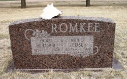
| Birth | : | 28 Sep 1878 Tingley Township, Ringgold County, Iowa, USA |
| Death | : | 23 Jun 1961 Tingley Township, Ringgold County, Iowa, USA |
| Burial | : | Rock Lake Community Cemetery, Rock Lake, Towner County, USA |
| Coordinate | : | 48.8024810, -99.2581270 |
frequently asked questions (FAQ):
-
Where is Kate Romke Weeda's memorial?
Kate Romke Weeda's memorial is located at: Rock Lake Community Cemetery, Rock Lake, Towner County, USA.
-
When did Kate Romke Weeda death?
Kate Romke Weeda death on 23 Jun 1961 in Tingley Township, Ringgold County, Iowa, USA
-
Where are the coordinates of the Kate Romke Weeda's memorial?
Latitude: 48.8024810
Longitude: -99.2581270
Family Members:
Parent
Spouse
Siblings
Children
Flowers:
Nearby Cemetories:
1. Rock Lake Community Cemetery
Rock Lake, Towner County, USA
Coordinate: 48.8024810, -99.2581270
2. All Nations Lutheran Cemetery
Rock Lake, Towner County, USA
Coordinate: 48.7807999, -99.2619019
3. Brumbaugh Cemetery
Towner County, USA
Coordinate: 48.7467003, -99.2102966
4. Mount View Cemetery
Towner County, USA
Coordinate: 48.8339005, -99.4156036
5. Ellison Cemetery
Rock Lake, Towner County, USA
Coordinate: 48.7906700, -99.0921900
6. Finnish Cemetery
Towner County, USA
Coordinate: 48.8199997, -99.4494019
7. Zion Cemetery
Towner County, USA
Coordinate: 48.6671982, -99.2307968
8. Perth Cemetery
Perth, Towner County, USA
Coordinate: 48.7052994, -99.4597015
9. Brethren Cemetery
Twin Hill Township, Towner County, USA
Coordinate: 48.6928250, -99.0467790
10. Hansboro Cemetery
Hansboro, Towner County, USA
Coordinate: 48.9565056, -99.3942500
11. Saint Pauls Presbyterian Cemetery
Towner County, USA
Coordinate: 48.6317420, -99.3940670
12. Holy Rosary Cemetery
Towner County, USA
Coordinate: 48.6317460, -99.3946620
13. Bisbee Lutheran Cemetery
Bisbee, Towner County, USA
Coordinate: 48.6316920, -99.3956110
14. Dash Cemetery
Towner County, USA
Coordinate: 48.9641991, -99.0830994
15. Egeland Union Cemetery
Egeland, Towner County, USA
Coordinate: 48.6171989, -99.0841980
16. Corinthian Cemetery
Calvin, Cavalier County, USA
Coordinate: 48.8622017, -98.9356003
17. Sarles Cemetery
Sarles, Cavalier County, USA
Coordinate: 48.9436290, -98.9900330
18. German Baptist Brethren Cemetery
Rolette County, USA
Coordinate: 48.6913000, -99.5655000
19. Emanuel Cemetery
Rolette County, USA
Coordinate: 48.7616997, -99.6066971
20. Rolla Cemetery
Rolla, Rolette County, USA
Coordinate: 48.8630028, -99.6016833
21. Saint Michael Cemetery
Rolla, Rolette County, USA
Coordinate: 48.8492012, -99.6157990
22. Clyde Cemetery
Bruce Township, Cavalier County, USA
Coordinate: 48.7764015, -98.8891983
23. McLean Family Cemetery
Cartwright, Pilot Mound Census Division, Canada
Coordinate: 49.0441800, -99.3344400
24. Saint Boniface Cemetery
Calio, Cavalier County, USA
Coordinate: 48.6697006, -98.9263992


