
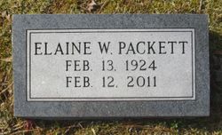
Katherine Elaine Whittaker Packett
| Birth | : | 13 Feb 1924 |
| Death | : | 12 Feb 2011 |
| Burial | : | Oakland Memorial Cemetery, Clarksville, Johnson County, USA |
| Coordinate | : | 35.4668999, -93.4756012 |
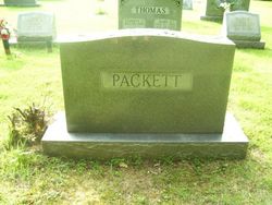
| Description | : | Obituary from the Currie Funeral Home (Kilmarnock, Va.) website, February 2011: Katherine Elaine Whittaker Packett, 86, of Weems died on Saturday, February 12, 2011. She was the widow of William E. Packett, Jr. and a member of Claybrook Baptist Church in Weems. Surviving are two sons and daughters-in-law, John E. and Sharon L. Packett of Troy, William "Bill" J. and Dorothy Packett of Weems; six grandchildren, Kathryn Ridings of Crozet, Christine Packett of Missoula, Montana, Dora Packett of Troy, Nickie Packett of Reedville, Tammy Sisson of Lively, Brenda Elbourne of White Stone; six great grandchildren, Hanna, Nathan and Maeve Ridings,... Read More |
frequently asked questions (FAQ):
-
Where is Katherine Elaine Whittaker Packett's memorial?
Katherine Elaine Whittaker Packett's memorial is located at: Oakland Memorial Cemetery, Clarksville, Johnson County, USA.
-
When did Katherine Elaine Whittaker Packett death?
Katherine Elaine Whittaker Packett death on 12 Feb 2011 in
-
Where are the coordinates of the Katherine Elaine Whittaker Packett's memorial?
Latitude: 35.4668999
Longitude: -93.4756012
Family Members:
Spouse
Flowers:


Nearby Cemetories:
1. Oakland Memorial Cemetery
Clarksville, Johnson County, USA
Coordinate: 35.4668999, -93.4756012
2. Lee Cemetery
Clarksville, Johnson County, USA
Coordinate: 35.4844017, -93.4602966
3. Pryor Cemetery
Clarksville, Johnson County, USA
Coordinate: 35.4880981, -93.4803009
4. Holy Redeemer Cemetery
Clarksville, Johnson County, USA
Coordinate: 35.4728012, -93.4456024
5. Walton Cemetery
Clarksville, Johnson County, USA
Coordinate: 35.4852982, -93.4982986
6. Shady Grove Cemetery
Clarksville, Johnson County, USA
Coordinate: 35.4719009, -93.5092010
7. Carter Cemetery
Clarksville, Johnson County, USA
Coordinate: 35.4411000, -93.4397000
8. Spadra Cemetery
Spadra, Johnson County, USA
Coordinate: 35.4281006, -93.5018997
9. Greenbrier
Clarksville, Johnson County, USA
Coordinate: 35.4697450, -93.4169700
10. Stillwell Cemetery
Clarksville, Johnson County, USA
Coordinate: 35.5191994, -93.4717026
11. Hays Chapel Cemetery
Clarksville, Johnson County, USA
Coordinate: 35.4470444, -93.5504837
12. Woodland Memorial Cemetery
Clarksville, Johnson County, USA
Coordinate: 35.5177994, -93.5242004
13. Old King Cemetery
Johnson County, USA
Coordinate: 35.5303605, -93.4579615
14. Blakeley Cemetery
Lamar, Johnson County, USA
Coordinate: 35.4439011, -93.3946991
15. Wood Cemetery
Johnson County, USA
Coordinate: 35.5317001, -93.5074997
16. King Cemetery
Ludwig, Johnson County, USA
Coordinate: 35.5377998, -93.4636002
17. Union Grove Cemetery
Clarksville, Johnson County, USA
Coordinate: 35.4767050, -93.5639190
18. Lamar Cemetery
Lamar, Johnson County, USA
Coordinate: 35.4399986, -93.3889999
19. Mount Airy Memorial Cemetery
Ludwig, Johnson County, USA
Coordinate: 35.5382996, -93.4282990
20. Macedonia Cemetery
Lamar, Johnson County, USA
Coordinate: 35.4930992, -93.3799973
21. Ragon Cemetery
Logan County, USA
Coordinate: 35.3896750, -93.5269240
22. Saints Peter and Paul Catholic Cemetery
Morrison Bluff, Logan County, USA
Coordinate: 35.3869019, -93.5286026
23. Lone Pine Cemetery
Clarksville, Johnson County, USA
Coordinate: 35.5546180, -93.5102610
24. Ware Chapel Cemetery
Cane Creek Township, Logan County, USA
Coordinate: 35.3745295, -93.4696293