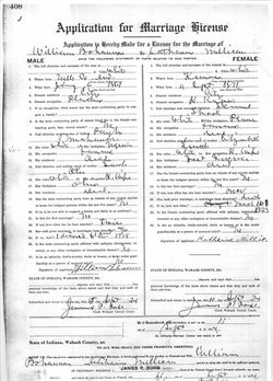
Katherine V. Shook Oates
| Birth | : | 4 Sep 1872 Atchison, Atchison County, Kansas, USA |
| Death | : | 30 Apr 1947 Andrews, Huntington County, Indiana, USA |
| Burial | : | Friends Cemetery, Chattanooga, Mercer County, USA |
| Coordinate | : | 40.6335983, -84.6466980 |
| Plot | : | Sec F, lot 194, sp 4 UNMARKED |
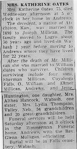
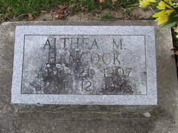
| Description | : | OBITUARY - Plain Dealer, Wabash (IN) Mrs. Katherine Oates, 75, died Wednesday afternoon at 5 o'clock in her home in Andrews. The decedent, a native of Atchison, Kan., was married in 1890 to Joseph Millican. The family moved to Lagro about 50 years ago and lived in Wabash one year before moving to Andrews where they have lived for 22 years. After the death of Mr. Millican, she was married to William Oates who survives. Children surviving include four sons, Sherman Millican, Cuyahoga Falls, O., William and Elmer Millican, Andrews, and Jesse, Huntington; one daughter, Mrs. Althea Hancock, Wabash; one siser, Mrs. Lydia... Read More |
frequently asked questions (FAQ):
-
Where is Katherine V. Shook Oates's memorial?
Katherine V. Shook Oates's memorial is located at: Friends Cemetery, Chattanooga, Mercer County, USA.
-
When did Katherine V. Shook Oates death?
Katherine V. Shook Oates death on 30 Apr 1947 in Andrews, Huntington County, Indiana, USA
-
Where are the coordinates of the Katherine V. Shook Oates's memorial?
Latitude: 40.6335983
Longitude: -84.6466980
Family Members:
Parent
Spouse
Siblings
Children
Nearby Cemetories:
1. Friends Cemetery
Chattanooga, Mercer County, USA
Coordinate: 40.6335983, -84.6466980
2. Stringtown Cemetery
Rockford, Mercer County, USA
Coordinate: 40.6556015, -84.6380997
3. Liberty Chapel Cemetery
Rockford, Mercer County, USA
Coordinate: 40.6336594, -84.6966248
4. Buck Cemetery
Celina, Mercer County, USA
Coordinate: 40.5950012, -84.6333008
5. Union Cemetery
Mercer County, USA
Coordinate: 40.6116982, -84.6007996
6. Mercer Cemetery
Mendon, Mercer County, USA
Coordinate: 40.6544914, -84.5821762
7. Chivington Cemetery
Mercer County, USA
Coordinate: 40.6587710, -84.5838620
8. Smith Cemetery
Rockford, Mercer County, USA
Coordinate: 40.6904420, -84.6445790
9. Fountain Chapel Cemetery
Mercer County, USA
Coordinate: 40.6692009, -84.7063980
10. Landfair Cemetery
Erastus, Mercer County, USA
Coordinate: 40.5969925, -84.7082901
11. Shindeldecker Cemetery
Rockford, Mercer County, USA
Coordinate: 40.6925011, -84.6219025
12. Roebuck Cemetery
Rockford, Mercer County, USA
Coordinate: 40.6918983, -84.6113968
13. Riverside Cemetery
Rockford, Mercer County, USA
Coordinate: 40.6974983, -84.6583023
14. Roberts Cemetery
Celina, Mercer County, USA
Coordinate: 40.6116982, -84.5618973
15. East Bethel Cemetery
Rockford, Mercer County, USA
Coordinate: 40.6547699, -84.7382965
16. Palmer Cemetery
Mercer County, USA
Coordinate: 40.6735992, -84.5631027
17. Roebuck Cemetery
Mercer, Mercer County, USA
Coordinate: 40.6351700, -84.5455700
18. Mount Olive Cemetery
Rockford, Mercer County, USA
Coordinate: 40.7043991, -84.6074982
19. Saint Pauls Lutheran Church Cemetery
Chattanooga, Mercer County, USA
Coordinate: 40.6228256, -84.7471848
20. Saint Pauls United Church of Christ Cemetery
Rockford, Mercer County, USA
Coordinate: 40.6108818, -84.7463531
21. Berry Cemetery
Center Township, Mercer County, USA
Coordinate: 40.5897750, -84.5564250
22. Fairview Cemetery
Mercer County, USA
Coordinate: 40.6082993, -84.5421982
23. Mercer Memory Gardens
Celina, Mercer County, USA
Coordinate: 40.5517120, -84.6055145
24. North Grove Cemetery
Celina, Mercer County, USA
Coordinate: 40.5630989, -84.5727997

