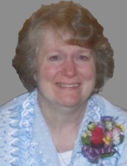
Kathleen Jean Groft Ratigan
| Birth | : | 27 Apr 1954 |
| Death | : | 24 Nov 2020 Redfield, Spink County, South Dakota, USA |
| Burial | : | Saint Ann Cemetery, Frankfort, Spink County, USA |
| Coordinate | : | 44.8821983, -98.3028030 |
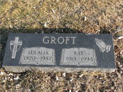
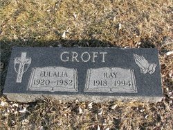
| Description | : | Kathleen Jean Groft was born on April 27, 1954, to Ray and Eulalia (Ruschenberg) Groft. Kathy attended grade school in Frankfort, SD and graduated from Redfield High School in 1972. Kathy married Gary Ratigan on August 25, 1973, and they had two boys. Kathy worked at the Spink County Auditor’s office in the courthouse in Redfield after her high school graduation until her early retirement due to health limitations. Kathy and Gary owned and operated Slim’s Gas Station in Frankfort from 1990 to 2000. She is survived by her two sons; eight grandchildren; two... Read More |
frequently asked questions (FAQ):
-
Where is Kathleen Jean Groft Ratigan's memorial?
Kathleen Jean Groft Ratigan's memorial is located at: Saint Ann Cemetery, Frankfort, Spink County, USA.
-
When did Kathleen Jean Groft Ratigan death?
Kathleen Jean Groft Ratigan death on 24 Nov 2020 in Redfield, Spink County, South Dakota, USA
-
Where are the coordinates of the Kathleen Jean Groft Ratigan's memorial?
Latitude: 44.8821983
Longitude: -98.3028030
Family Members:
Parent
Spouse
Flowers:
Nearby Cemetories:
1. Saint Ann Cemetery
Frankfort, Spink County, USA
Coordinate: 44.8821983, -98.3028030
2. Frankfort Cemetery
Frankfort, Spink County, USA
Coordinate: 44.8784800, -98.2965200
3. Poor Farm Cemetery
Frankfort, Spink County, USA
Coordinate: 44.8836350, -98.3591071
4. Guttenberg Cemetery
Spink County, USA
Coordinate: 44.8205986, -98.2972031
5. Glendale Colony Cemetery
Spink County, USA
Coordinate: 44.7999900, -98.2856600
6. Irving Cemetery
Doland, Spink County, USA
Coordinate: 44.7751500, -98.2203600
7. Clifton Cemetery
Clifton Township, Spink County, USA
Coordinate: 45.0106010, -98.3197021
8. Spink Colony Cemetery
Spink Colony, Spink County, USA
Coordinate: 44.7440800, -98.2923800
9. Crandon Cemetery
Spink County, USA
Coordinate: 44.7825012, -98.4436035
10. Graceland Cemetery
Tulare, Spink County, USA
Coordinate: 44.7481003, -98.3861008
11. Saint Bernard Cemetery
Redfield, Spink County, USA
Coordinate: 44.8857994, -98.5139008
12. Ebenezer Cemetery
Doland, Spink County, USA
Coordinate: 44.7602997, -98.1797028
13. Greenlawn Cemetery
Redfield, Spink County, USA
Coordinate: 44.8857994, -98.5164032
14. Rose Hill Cemetery
Doland, Spink County, USA
Coordinate: 44.7484600, -98.1993600
15. Irving Cemetery
Spink County, USA
Coordinate: 44.7486000, -98.1986008
16. South Dakota Developmental Center Cemetery
Spink County, USA
Coordinate: 44.8880120, -98.5234880
17. Doland Cemetery
Doland, Spink County, USA
Coordinate: 44.8993988, -98.0828018
18. Tulare Cemetery
Tulare, Spink County, USA
Coordinate: 44.7486000, -98.4922028
19. Ashton Cemetery
Ashton, Spink County, USA
Coordinate: 44.9914017, -98.5224991
20. Hillestad Cemetery
Spink County, USA
Coordinate: 44.6944008, -98.2596970
21. Emmanuel Mennonite Cemetery
Spink County, USA
Coordinate: 44.7041300, -98.1207900
22. Saint Josephs Cemetery
Turton, Spink County, USA
Coordinate: 45.0479660, -98.0899500
23. Sunnyside Cemetery
Turton, Spink County, USA
Coordinate: 45.0472600, -98.0849800
24. Hillside Colony Cemetery
Hillside Colony, Spink County, USA
Coordinate: 44.7404700, -98.0486100


