
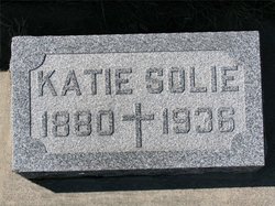

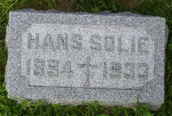
Kathryn A. “Katie” Roche Solie
| Birth | : | 1880 Iowa, USA |
| Death | : | 14 Apr 1934 Redfield, Spink County, South Dakota, USA |
| Burial | : | Barmera Cemetery, Barmera, Berri Barmera Council, Australia |
| Coordinate | : | -34.2642300, 140.4435640 |
| Plot | : | Blk 2, Lot 6, Gr 2 |
| Description | : | It appears both Hans and Katie have incorrect death years engraved on their stones. I also find that surnames are spelled "Soli" on original SD death records. Name: Katherine R Soli Death Date: 14 Apr 1934 Death Place: Spink , South Dakota , USA Certificate Number: 155402 Page Number: 708 ===== Suggested edit: Obituary in The Evening Huronite, Apr 16, 1934, pg 11. South Dakota, Death Index, 1879-1955 - Katherine R Solie died Apr. 14, 1934, Spink county Contributor: reo (46840721) ===== Regarding their place of residence: In the 1930 Census for Spink Co., SD, the correct township... Read More |
frequently asked questions (FAQ):
-
Where is Kathryn A. “Katie” Roche Solie's memorial?
Kathryn A. “Katie” Roche Solie's memorial is located at: Barmera Cemetery, Barmera, Berri Barmera Council, Australia.
-
When did Kathryn A. “Katie” Roche Solie death?
Kathryn A. “Katie” Roche Solie death on 14 Apr 1934 in Redfield, Spink County, South Dakota, USA
-
Where are the coordinates of the Kathryn A. “Katie” Roche Solie's memorial?
Latitude: -34.2642300
Longitude: 140.4435640
Family Members:
Parent
Spouse
Siblings
Flowers:


Nearby Cemetories:
1. Barmera Cemetery
Barmera, Berri Barmera Council, Australia
Coordinate: -34.2642300, 140.4435640
2. Moorook Cemetery
Moorook, District Council of Loxton Waikerie, Australia
Coordinate: -34.2919660, 140.3523210
3. Kingston on Murray
Kingston, District Council of Loxton Waikerie, Australia
Coordinate: -34.2330100, 140.3493100
4. New Residence Trinity Lutheran Church Cemetery
Moorook, District Council of Loxton Waikerie, Australia
Coordinate: -34.3726190, 140.4054430
5. Berri General Cemetery
Berri, Berri Barmera Council, Australia
Coordinate: -34.2764387, 140.5888914
6. Overland Corner Cemetery
Barmera, Berri Barmera Council, Australia
Coordinate: -34.1475900, 140.3426400
7. Bookpurnong Pilgrims of Zion Lutheran Cemetery
Berri, Berri Barmera Council, Australia
Coordinate: -34.3281160, 140.6062620
8. Loxton North Cemetery
Loxton, District Council of Loxton Waikerie, Australia
Coordinate: -34.3939900, 140.6017800
9. Myrla Lutheran Cemetery
Wunkar, District Council of Loxton Waikerie, Australia
Coordinate: -34.4513750, 140.3225740
10. Loxton Cemetery
Loxton, District Council of Loxton Waikerie, Australia
Coordinate: -34.4556160, 140.5714420
11. Renmark Cemetery
Renmark, Renmark Paringa Council, Australia
Coordinate: -34.1723650, 140.7225840
12. Stoeckel Family Cemetery
Paringa, Renmark Paringa Council, Australia
Coordinate: -34.1785780, 140.7803160
13. Bugle Hut Lutheran Cemetery
Loxton, District Council of Loxton Waikerie, Australia
Coordinate: -34.3607730, 140.7801570
14. Paringa Cemetery
Paringa, Renmark Paringa Council, Australia
Coordinate: -34.1628170, 140.7821640
15. Saint Paul's Lutheran Churchyard
Lowbank, District Council of Loxton Waikerie, Australia
Coordinate: -34.1906660, 140.0813100
16. Taplan Saint John Lutheran Cemetery
Taplan, District Council of Loxton Waikerie, Australia
Coordinate: -34.5455690, 140.0000000
17. Alawoona Cemetery
Alawoona, District Council of Loxton Waikerie, Australia
Coordinate: -34.7335890, 140.5090860
18. Wanbi Cemetery
Wanbi, District Council of Karoonda East Murray, Australia
Coordinate: -34.7634610, 140.2968910
19. Paruna Cemetery
District Council of Loxton Waikerie, Australia
Coordinate: -34.7251500, 140.7405500
20. Galga Cemetery
Waikerie, District Council of Loxton Waikerie, Australia
Coordinate: -34.6889690, 140.0567010
21. Meribah Cemetery
Meribah, District Council of Loxton Waikerie, Australia
Coordinate: -34.7060680, 140.8637590
22. Cadell Cemetery
Cadell, Mid Murray Council, Australia
Coordinate: -34.0430120, 139.7592360
23. Bethlehem Lutheran Cemetery
Cadell, Mid Murray Council, Australia
Coordinate: -34.1628165, 139.6645527
24. Bethlehem Lutheran Church Cemetery
Murbko, Mid Murray Council, Australia
Coordinate: -34.1657770, 139.6629100