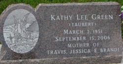
Kathy Taubert Green
| Birth | : | 2 Mar 1951 Ponca, Dixon County, Nebraska, USA |
| Death | : | 15 Sep 2006 Iowa, USA |
| Burial | : | Pence Cemetery, Baldwin, Jackson County, USA |
| Coordinate | : | 42.0746994, -90.8106003 |
| Description | : | Kathy Green Family in SSC Kathy Green, 55, of Urbandale, Iowa passed away Sept. 15 due to cancer. Services were held Wednesday, Sept. 20 at the United Methodist Church in Ponca. Burial followed at the Ponca cemetery. Kathy was born March 2, 1951 in Ponca to Dean and Orladelle (Polkinghorn) Taubert. She was the second child of four. She went to country school, then one year at Wynot until moving to South Sioux City. She graduated in 1969 from South Sioux City High School. After graduating she worked at Aalfs Mfg. She married Dennis Green in 1970, later having three children, they... Read More |
frequently asked questions (FAQ):
-
Where is Kathy Taubert Green's memorial?
Kathy Taubert Green's memorial is located at: Pence Cemetery, Baldwin, Jackson County, USA.
-
When did Kathy Taubert Green death?
Kathy Taubert Green death on 15 Sep 2006 in Iowa, USA
-
Where are the coordinates of the Kathy Taubert Green's memorial?
Latitude: 42.0746994
Longitude: -90.8106003
Family Members:
Parent
Flowers:
Nearby Cemetories:
1. Pence Cemetery
Baldwin, Jackson County, USA
Coordinate: 42.0746994, -90.8106003
2. Hershberger Cemetery
Baldwin, Jackson County, USA
Coordinate: 42.0772309, -90.8418011
3. Holy Trinity Catholic Cemetery
Baldwin, Jackson County, USA
Coordinate: 42.0770000, -90.8420000
4. Reel Cemetery
Baldwin, Jackson County, USA
Coordinate: 42.1049995, -90.8510971
5. Buckhorn Waterford Cemetery
Buckhorn, Jackson County, USA
Coordinate: 42.0607986, -90.7517014
6. Monmouth Cemetery
Monmouth, Jackson County, USA
Coordinate: 42.0679300, -90.8798400
7. Washington Cemetery
Clinton County, USA
Coordinate: 42.0119019, -90.8399963
8. Goddard Cemetery
Maquoketa, Jackson County, USA
Coordinate: 42.0391998, -90.7335968
9. West Iron Hill Cemetery
Jackson County, USA
Coordinate: 42.1460000, -90.7686000
10. Busch Cemetery
Clinton County, USA
Coordinate: 41.9996986, -90.7818985
11. East Iron Hill Cemetery
Farmers Creek Township, Jackson County, USA
Coordinate: 42.1465797, -90.7591019
12. Smithtown Cemetery
Lost Nation, Clinton County, USA
Coordinate: 41.9955000, -90.8555000
13. Esgate Cemetery
Maquoketa, Jackson County, USA
Coordinate: 42.1292000, -90.7142029
14. Willison Cemetery
Jackson County, USA
Coordinate: 42.1646000, -90.7783000
15. Elwood Cemetery
Elwood, Clinton County, USA
Coordinate: 41.9935989, -90.7307968
16. Crabb Cemetery
Crab Town, Jackson County, USA
Coordinate: 42.1749992, -90.8022003
17. Rustic Park
Clinton County, USA
Coordinate: 41.9712334, -90.8088684
18. Hickory Grove Cemetery
Emeline, Jackson County, USA
Coordinate: 42.1719017, -90.8600006
19. Tracy Cemetery
Jackson County, USA
Coordinate: 42.1805992, -90.8067017
20. Tilton Cemetery
Jackson County, USA
Coordinate: 42.1236000, -90.6798000
21. Sacred Heart Cemetery
Lost Nation, Clinton County, USA
Coordinate: 41.9659500, -90.8199500
22. Streets Cemetery
Ironhills, Jackson County, USA
Coordinate: 42.1796989, -90.7692032
23. Lost Nation Cemetery
Lost Nation, Clinton County, USA
Coordinate: 41.9654000, -90.8184000
24. Mount Hope Cemetery
Maquoketa, Jackson County, USA
Coordinate: 42.0615616, -90.6619720


