

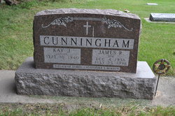
Kay Jean Davis Cunningham
| Birth | : | 10 Sep 1940 Charles City, Floyd County, Iowa, USA |
| Death | : | 13 Dec 2020 West Burlington, Des Moines County, Iowa, USA |
| Burial | : | Saint Patricks Catholic Cemetery, Dougherty, Cerro Gordo County, USA |
| Coordinate | : | 42.9227791, -93.0294418 |
| Description | : | Suggested edit: Kay Davis Cunningham, 80, of Mason City, died peacefully on Sunday, 13 Dec 2020, at The Great River Medical Center in West Burlington, IA. Visitation will be held from 11 to 1:00 p.m. Saturday, 19 Dec at Hogan Bremer Moore Colonial Chapel, 126 3rd St. NE, Mason City, where a service will be held at 1:00 p.m. Immediately following will be burial in St. Patrick’s Catholic Cemetery, Dougherty, IA. Memorials may be directed to the family. As mandated by proclamation, social distancing must be practiced. The use of facemasks or shields is required. For... Read More |
frequently asked questions (FAQ):
-
Where is Kay Jean Davis Cunningham's memorial?
Kay Jean Davis Cunningham's memorial is located at: Saint Patricks Catholic Cemetery, Dougherty, Cerro Gordo County, USA.
-
When did Kay Jean Davis Cunningham death?
Kay Jean Davis Cunningham death on 13 Dec 2020 in West Burlington, Des Moines County, Iowa, USA
-
Where are the coordinates of the Kay Jean Davis Cunningham's memorial?
Latitude: 42.9227791
Longitude: -93.0294418
Family Members:
Parent
Spouse
Children


Nearby Cemetories:
1. Saint Patricks Catholic Cemetery
Dougherty, Cerro Gordo County, USA
Coordinate: 42.9227791, -93.0294418
2. West Fork Cemetery
Franklin County, USA
Coordinate: 42.8918991, -93.0836029
3. Saint John Zion Cemetery
Sheffield, Franklin County, USA
Coordinate: 42.8969002, -93.1472015
4. Halls Grove Cemetery
Greene, Butler County, USA
Coordinate: 42.8840100, -92.8782300
5. Westside Cemetery
Marble Rock, Floyd County, USA
Coordinate: 42.9556007, -92.8739014
6. Sacred Heart Cemetery
Rockwell, Cerro Gordo County, USA
Coordinate: 42.9592018, -93.1913986
7. Hillside Cemetery
Marble Rock, Floyd County, USA
Coordinate: 42.9583015, -92.8666992
8. Hillside Cemetery
Sheffield, Franklin County, USA
Coordinate: 42.9006004, -93.2007980
9. Rockwell Cemetery
Rockwell, Cerro Gordo County, USA
Coordinate: 42.9786000, -93.1919000
10. Needham Cemetery
Bristow, Butler County, USA
Coordinate: 42.7956500, -92.9726300
11. Riverside Cemetery
Rockford, Floyd County, USA
Coordinate: 43.0578003, -92.9464035
12. Harlan Cemetery
Dumont, Butler County, USA
Coordinate: 42.7663994, -93.0143967
13. Hansell Cemetery
Franklin County, USA
Coordinate: 42.7666702, -93.1047211
14. North Vilmar Cemetery
Vilmar, Butler County, USA
Coordinate: 42.8329700, -92.8392900
15. Oak Hill Cemetery
Bristow, Butler County, USA
Coordinate: 42.7719002, -92.9353027
16. Way Side Cemetery
Chapin, Franklin County, USA
Coordinate: 42.8293991, -93.2225037
17. Old Bristow Cemetery
Bristow, Butler County, USA
Coordinate: 42.7733078, -92.9165845
18. Owens Grove Cemetery
Cerro Gordo County, USA
Coordinate: 43.0825005, -93.1144180
19. Dumont Cemetery
Dumont, Butler County, USA
Coordinate: 42.7553177, -92.9748230
20. Rose Hill Cemetery
Greene, Butler County, USA
Coordinate: 42.8843994, -92.7988968
21. Flood Creek Cemetery
Floyd County, USA
Coordinate: 43.0391998, -92.8538971
22. Saint Marys Cemetery
Greene, Butler County, USA
Coordinate: 42.8827300, -92.7990200
23. Hardeman Cemetery
Greene, Butler County, USA
Coordinate: 42.8706017, -92.8013992
24. Shobes Grove Cemetery
Franklin County, USA
Coordinate: 42.9000015, -93.2722168