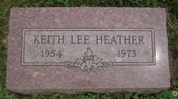
Keith Lee Heather
| Birth | : | 16 Nov 1954 Syracuse, Otoe County, Nebraska, USA |
| Death | : | 11 Mar 1973 Syracuse, Otoe County, Nebraska, USA |
| Burial | : | St. Andrew's United Church Cemetery, Vernonville, Northumberland County, Canada |
| Coordinate | : | 44.0480000, -77.9842100 |
| Description | : | Keith Heather, 18, a 1972 graduate of Syracuse-Dunbar-Avoca High School, became Otoe County's first traffic victim of 1973 when the pickup truck he was driving plunged into Muddy Creek southwest of Syracuse. He was found pinned in the truck, with death apparently caused by downing, according to Bill Zastera, assistant county attorney and acting coroner. The accident ocurred when Heather apparently failed to see that the center span of a steel and wooden bridge on a county road had been torn away, apparently by debris from high water. The accident happened between 7:30PM Saturday, when the bridge was last seen intact,... Read More |
frequently asked questions (FAQ):
-
Where is Keith Lee Heather's memorial?
Keith Lee Heather's memorial is located at: St. Andrew's United Church Cemetery, Vernonville, Northumberland County, Canada.
-
When did Keith Lee Heather death?
Keith Lee Heather death on 11 Mar 1973 in Syracuse, Otoe County, Nebraska, USA
-
Where are the coordinates of the Keith Lee Heather's memorial?
Latitude: 44.0480000
Longitude: -77.9842100
Family Members:
Parent
Siblings
Flowers:
Nearby Cemetories:
1. St. Andrew's United Church Cemetery
Vernonville, Northumberland County, Canada
Coordinate: 44.0480000, -77.9842100
2. Academy Hill Cemetery
Centreton, Northumberland County, Canada
Coordinate: 44.0282360, -78.0348730
3. Fairview Cemetery
Grafton, Northumberland County, Canada
Coordinate: 43.9960600, -78.0074600
4. Saint Marys Cemetery
Grafton, Northumberland County, Canada
Coordinate: 43.9971700, -78.0260000
5. Castleton Cemetery
Castleton, Northumberland County, Canada
Coordinate: 44.0978070, -77.9321410
6. Saint Andrew's United Presbyterian Church Cemetery
Grafton, Northumberland County, Canada
Coordinate: 43.9915560, -78.0255940
7. Saint George's Anglican Church Cemetery
Grafton, Northumberland County, Canada
Coordinate: 43.9917600, -78.0286600
8. Colborne Union Cemetery
Colborne, Northumberland County, Canada
Coordinate: 44.0208920, -77.9015110
9. Gilliland Cemetery
Haldimand, Northumberland County, Canada
Coordinate: 44.0458800, -78.0853300
10. Russ Creek Cemetery
Haldimand, Northumberland County, Canada
Coordinate: 44.1267700, -77.9859312
11. Colborne Trinity Anglican Cemetery
Colborne, Northumberland County, Canada
Coordinate: 44.0061950, -77.8830993
12. Lakeport Cemetery
Lakeport, Northumberland County, Canada
Coordinate: 43.9851767, -77.9063741
13. East Colborne Cemetery
Colborne, Northumberland County, Canada
Coordinate: 44.0060700, -77.8724900
14. Bethel United Cemetery
Haldimand, Northumberland County, Canada
Coordinate: 44.1422200, -78.0526000
15. Salem Cemetery
Cramahe, Northumberland County, Canada
Coordinate: 44.0160240, -77.8390420
16. Bowmanton Cemetery
Northumberland County, Canada
Coordinate: 44.1077620, -78.1268720
17. Baltimore United Church Cemetery
Baltimore, Northumberland County, Canada
Coordinate: 44.0234500, -78.1462900
18. Waite Cemetery
Wade Corners, Northumberland County, Canada
Coordinate: 44.0645230, -77.8041890
19. Cramahe Hill Cemetery
Cramahe, Northumberland County, Canada
Coordinate: 44.1488182, -77.8559095
20. Woods Cemetery
Colborne, Northumberland County, Canada
Coordinate: 44.0241717, -77.7887043
21. Carr Cemetery
Cramahe, Northumberland County, Canada
Coordinate: 44.1469320, -77.8372980
22. Alderville Reserve Cemetery
Alderville, Northumberland County, Canada
Coordinate: 44.1796000, -78.0760800
23. Stone's Cemetery
Trent Hills, Northumberland County, Canada
Coordinate: 44.1751330, -77.8798290
24. Stone's Cemetery
Percy, Northumberland County, Canada
Coordinate: 44.1751330, -77.8798290


