
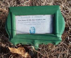
Kenneth A. “Kenny” Hoerle
| Birth | : | 22 Jan 1928 Chambers, Holt County, Nebraska, USA |
| Death | : | 8 Nov 2006 Adams County, Nebraska, USA |
| Burial | : | Stanton Cemetery, Stanton, Stanton County, USA |
| Coordinate | : | 41.9599991, -97.2121964 |
| Plot | : | Block 3, Lot 22 |
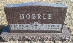
| Description | : | Son of Lloyd & Delma (Cady) Hoerle. Married to Beth Helms on 10-18-1995. From the Grand Island, NE. "Independent" Newspaper: A Kenesaw man was killed Wednesday morning when the pickup he was driving was hit by a train. Kenneth Hoerle, 68, was northbound on Wanda Avenue, about four miles northeast of Kenesaw, at 9:30 a.m. when the passenger side of his white 1997 Dodge pickup was struck by a westbound Union Pacific train, according to a news release from the Adams County Sheriff's Department. He was pronounced dead at the scene. Hoerle was not wearing his seat belt. After he was pronounced dead, the Jaws... Read More |
frequently asked questions (FAQ):
-
Where is Kenneth A. “Kenny” Hoerle's memorial?
Kenneth A. “Kenny” Hoerle's memorial is located at: Stanton Cemetery, Stanton, Stanton County, USA.
-
When did Kenneth A. “Kenny” Hoerle death?
Kenneth A. “Kenny” Hoerle death on 8 Nov 2006 in Adams County, Nebraska, USA
-
Where are the coordinates of the Kenneth A. “Kenny” Hoerle's memorial?
Latitude: 41.9599991
Longitude: -97.2121964
Family Members:
Parent

Flowers:


Nearby Cemetories:
1. Stanton Cemetery
Stanton, Stanton County, USA
Coordinate: 41.9599991, -97.2121964
2. Zilmer Cemetery
Stanton, Stanton County, USA
Coordinate: 41.9464000, -97.2528000
3. Belz Cemetery
Stanton, Stanton County, USA
Coordinate: 41.9528008, -97.2619019
4. Koch Cemetery
Stanton County, USA
Coordinate: 41.9855995, -97.1731033
5. Zander Cemetery
Stanton County, USA
Coordinate: 41.9888992, -97.1750031
6. Hoosier Hollow Pioneer Cemetery
Stanton County, USA
Coordinate: 41.9900017, -97.2814026
7. Elkhorn Cemetery
Pilger, Stanton County, USA
Coordinate: 41.9899910, -97.1316720
8. Norwegian Cemetery
Stanton, Stanton County, USA
Coordinate: 41.9171600, -97.2907160
9. Bethlehem Cemetery
Stanton County, USA
Coordinate: 42.0332985, -97.2241974
10. Kuehn Cemetery
Pilger, Stanton County, USA
Coordinate: 41.9682000, -97.1049000
11. Erychleb Cemetery
Stanton County, USA
Coordinate: 41.8664017, -97.2138977
12. Bega Cemetery
Stanton County, USA
Coordinate: 42.0736008, -97.2343979
13. Muller Cemetery
Pilger, Stanton County, USA
Coordinate: 42.0780940, -97.1781920
14. Schwedt Cemetery
Pilger, Stanton County, USA
Coordinate: 41.9240000, -97.0480000
15. Pilger Cemetery
Pilger, Stanton County, USA
Coordinate: 42.0217018, -97.0591965
16. Zion Cemetery
Stanton County, USA
Coordinate: 42.0421982, -97.3638992
17. Christ Lutheran Cemetery
Stanton County, USA
Coordinate: 42.0433006, -97.3636017
18. Norfolk State Hospital New Cemetery
Norfolk, Madison County, USA
Coordinate: 42.0475500, -97.3698300
19. Spring Branch Cemetery
Spring Branch Township, Stanton County, USA
Coordinate: 42.0789400, -97.3297400
20. Saint Matthews Lutheran Cemetery
Wisner, Cuming County, USA
Coordinate: 41.9175000, -97.0189000
21. Norfolk State Hospital Old Cemetery
Norfolk, Madison County, USA
Coordinate: 42.0535400, -97.3733100
22. Pleasant Valley Cemetery
Madison County, USA
Coordinate: 41.8877983, -97.3972015
23. E U B Cemetery
Hoskins, Wayne County, USA
Coordinate: 42.1137900, -97.3015700
24. Trinity Cemetery
Hoskins, Wayne County, USA
Coordinate: 42.1055984, -97.3274994