
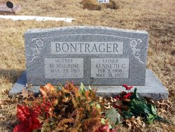
Kenneth C Bontrager
| Birth | : | 5 Feb 1908 Goff, Nemaha County, Kansas, USA |
| Death | : | 31 May 1977 Holton, Jackson County, Kansas, USA |
| Burial | : | Prospect Cemetery, Hollow Rock, Carroll County, USA |
| Coordinate | : | 36.0346985, -88.2703018 |
| Plot | : | Section K |
| Inscription | : | Father |
| Description | : | Topeka State Journal Wednesday June 1, 1977, pg. 35: HOLTON - Kenneth C. Bontrager, 69, Holton, died Tuesday in a Holton hospital where he was admitted May 16. He was born Feb. 5, 1908 at Goff and lived at Wetmore and then at Circleville before he moved to Holton about 7 years ago. Mr. Bontrager operated a grocery store and locker plant at Wetmore and later at Circleville before he retired in 1969. He was a member of Circleville Lodge No. 20, AF&AM and Circleville Chapter No. 293, Order of Eastern Star, both at Circleville. He married Maurine Camp Feb.... Read More |
frequently asked questions (FAQ):
-
Where is Kenneth C Bontrager's memorial?
Kenneth C Bontrager's memorial is located at: Prospect Cemetery, Hollow Rock, Carroll County, USA.
-
When did Kenneth C Bontrager death?
Kenneth C Bontrager death on 31 May 1977 in Holton, Jackson County, Kansas, USA
-
Where are the coordinates of the Kenneth C Bontrager's memorial?
Latitude: 36.0346985
Longitude: -88.2703018
Family Members:
Parent
Spouse

Siblings
Children
Flowers:


Nearby Cemetories:
1. Prospect Cemetery
Hollow Rock, Carroll County, USA
Coordinate: 36.0346985, -88.2703018
2. Rowland Cemetery #2
Bruceton, Carroll County, USA
Coordinate: 36.0349500, -88.2608700
3. Nebo - Pisgah Cemetery
Hollow Rock, Carroll County, USA
Coordinate: 36.0427190, -88.2604730
4. Hollow Rock Church Cemetery
Bruceton, Carroll County, USA
Coordinate: 36.0393550, -88.2493720
5. Rowland Cemetery
Hollow Rock, Carroll County, USA
Coordinate: 36.0161184, -88.2745960
6. New Prospect Cemetery
Hollow Rock, Carroll County, USA
Coordinate: 36.0579930, -88.2734330
7. Old Pisgah Church Cemetery
Bruceton, Carroll County, USA
Coordinate: 36.0602989, -88.2553024
8. Thompson Cemetery
Bruceton, Carroll County, USA
Coordinate: 36.0321880, -88.3202350
9. Hebron Cemetery
Carroll County, USA
Coordinate: 36.0410995, -88.3199997
10. Park Cemetery
Bruceton, Carroll County, USA
Coordinate: 36.0110390, -88.2281580
11. Pisgah Cemetery
Hollow Rock, Carroll County, USA
Coordinate: 36.0788570, -88.2638470
12. Nesbitt Cemetery
Hollow Rock, Carroll County, USA
Coordinate: 36.0633011, -88.3218994
13. Garrett Cemetery
Buena Vista, Carroll County, USA
Coordinate: 35.9925000, -88.2339000
14. Hamilton Cemetery
Carroll County, USA
Coordinate: 36.0069008, -88.3289032
15. Marlboro Church of Christ Cemetery
Bruceton, Carroll County, USA
Coordinate: 36.0919200, -88.2693600
16. Marlsboro Missionary Baptist Church Cemetery
Carroll County, USA
Coordinate: 36.0928001, -88.2694016
17. Ray Cemetery
Carroll County, USA
Coordinate: 35.9930992, -88.3225021
18. Spellings Cemetery
Buena Vista, Carroll County, USA
Coordinate: 35.9787980, -88.2954990
19. Mount Pleasant Baptist Church Cemetery
Huntingdon, Carroll County, USA
Coordinate: 36.0388090, -88.3440580
20. Mebane Cemetery
Carroll County, USA
Coordinate: 36.0689011, -88.3311005
21. Mount Carmel Cemetery
Camden, Benton County, USA
Coordinate: 36.0598850, -88.2017880
22. McAuley Cemetery
Buena Vista, Carroll County, USA
Coordinate: 35.9822006, -88.3091965
23. Groom Family Cemetery
Vale, Carroll County, USA
Coordinate: 36.0977670, -88.2524950
24. Barren Springs Church Cemetery
Hollow Rock, Carroll County, USA
Coordinate: 36.0890140, -88.3152590