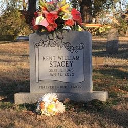
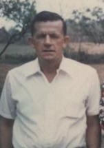
Kent William Stacey
| Birth | : | 1966 Woodbury, Cannon County, Tennessee, USA |
| Death | : | 12 Jan 2020 St. Louis County, Missouri, USA |
| Burial | : | Gilley Hill Cemetery, Hollow Springs, Cannon County, USA |
| Coordinate | : | 35.6805992, -86.1444016 |
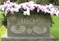
| Description | : | Kent William Stacey January 12, 2020 Obituary Kent William Stacey, 54, passed away on Sunday January 12, 2020 at St. Luke's hospital in St. Louis, MO with his family by his side. Kent was a native of Cannon County but has lived in St. Louis (Wildwood) Missouri for the last 6 years. He is preceded in death by his parents, C.C.(Kent) and Elizabeth Bryson Stacey and his brother, Johnny Clark Stacey and his brother-in-law, Tommy Arnold. Survivors include two sisters, and a sister-in-law; Niece & Nephews; Great nephews and great... Read More |
frequently asked questions (FAQ):
-
Where is Kent William Stacey's memorial?
Kent William Stacey's memorial is located at: Gilley Hill Cemetery, Hollow Springs, Cannon County, USA.
-
When did Kent William Stacey death?
Kent William Stacey death on 12 Jan 2020 in St. Louis County, Missouri, USA
-
Where are the coordinates of the Kent William Stacey's memorial?
Latitude: 35.6805992
Longitude: -86.1444016
Family Members:
Parent
Siblings
Flowers:
Nearby Cemetories:
1. Gilley Hill Cemetery
Hollow Springs, Cannon County, USA
Coordinate: 35.6805992, -86.1444016
2. Burk Cemetery
Beech Grove, Coffee County, USA
Coordinate: 35.6733017, -86.1575012
3. Bush Cemetery
Cannon County, USA
Coordinate: 35.6617440, -86.1300840
4. Espy Cemetery
Cannon County, USA
Coordinate: 35.6893997, -86.1166992
5. Anderson Cemetery
Coffee County, USA
Coordinate: 35.6567001, -86.1766968
6. Jernigan Hill Cemetery
Hoodoo, Coffee County, USA
Coordinate: 35.6656617, -86.1842912
7. Hopewell Cemetery
Cannon County, USA
Coordinate: 35.7122002, -86.1710968
8. Bynum Cemetery
Cannon County, USA
Coordinate: 35.7164001, -86.1635971
9. Parker Hill Cemetery
Cannon County, USA
Coordinate: 35.7052090, -86.0977260
10. Hettie Cemetery
Coffee County, USA
Coordinate: 35.6939011, -86.2003021
11. Green-Messick Cemetery
Coffee County, USA
Coordinate: 35.6713982, -86.2027969
12. Hoodoo Cemetery
Hoodoo, Coffee County, USA
Coordinate: 35.6386108, -86.1769409
13. Green Cemetery
Coffee County, USA
Coordinate: 35.7016983, -86.2016983
14. Jernigan Cemetery
Coffee County, USA
Coordinate: 35.6875000, -86.2071991
15. Sagely Cemetery
Cannon County, USA
Coordinate: 35.7127991, -86.1977997
16. Jernigan Cemetery
Cannon County, USA
Coordinate: 35.7214012, -86.1900024
17. Gnat Hill Cemetery
Manchester, Coffee County, USA
Coordinate: 35.6238899, -86.1426392
18. Milligan Cemetery
Cannon County, USA
Coordinate: 35.7386017, -86.1231003
19. George Family Cemetery
Bradyville, Cannon County, USA
Coordinate: 35.6726307, -86.0683404
20. Patton Cemetery
Cannon County, USA
Coordinate: 35.7430992, -86.1541977
21. Green and Douglas Cemetery
Coffee County, USA
Coordinate: 35.7019005, -86.2174988
22. Cherry Cemetery
Hollow Springs, Cannon County, USA
Coordinate: 35.7263985, -86.0864029
23. Burk Cemetery
Donnell Chapel, Rutherford County, USA
Coordinate: 35.7178001, -86.2117004
24. Cooley Cemetery
Gnat Hill, Coffee County, USA
Coordinate: 35.6262283, -86.0970993


