
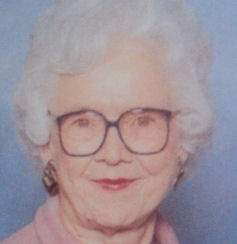
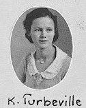

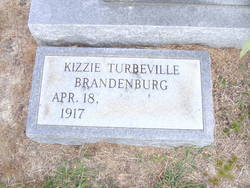
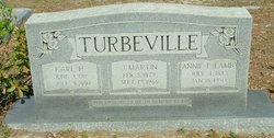
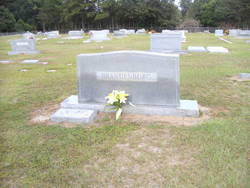
Kizzie Turbeville Brandenburg
| Birth | : | 18 Apr 1917 Turbeville, Clarendon County, South Carolina, USA |
| Death | : | 14 Nov 2012 Orangeburg, Orangeburg County, South Carolina, USA |
| Burial | : | Millicent Cemetery, Millicent, Wattle Range Council, Australia |
| Coordinate | : | -37.6184335, 140.3770980 |
| Description | : | Mrs. Kizzie Turbeville Brandenburg, 95, widow of William "Bill" Brandenburg, died Wednesday, Nov. 14, 2012, at the Regional Medical Center. Funeral services will be held at 2 p.m. Saturday, Nov. 17, at First Baptist Church in Holly Hill, with Dr. Ron Heddle and Dr. David Brien officiating. Burial will be in Holly Hill Cemetery. Mrs. Brandenburg was born in Turbeville, a daughter of the late James Martin Turbeville and Lamb Evans Turbeville. She was co-owner of the former Brandenburg's Grocery and Esso Station. Mrs. Brandenburg was a very active member of First Baptist Church when her health permitted. Surviving are a granddaughter, Carmen... Read More |
frequently asked questions (FAQ):
-
Where is Kizzie Turbeville Brandenburg's memorial?
Kizzie Turbeville Brandenburg's memorial is located at: Millicent Cemetery, Millicent, Wattle Range Council, Australia.
-
When did Kizzie Turbeville Brandenburg death?
Kizzie Turbeville Brandenburg death on 14 Nov 2012 in Orangeburg, Orangeburg County, South Carolina, USA
-
Where are the coordinates of the Kizzie Turbeville Brandenburg's memorial?
Latitude: -37.6184335
Longitude: 140.3770980
Family Members:
Parent

Spouse
Siblings

Flowers:


Nearby Cemetories:
1. Millicent Cemetery
Millicent, Wattle Range Council, Australia
Coordinate: -37.6184335, 140.3770980
2. Kalangadoo Cemetery
Kalangadoo, Wattle Range Council, Australia
Coordinate: -37.5694190, 140.7045780
3. Beachport Cemetery
Beachport, Wattle Range Council, Australia
Coordinate: -37.4725340, 140.0475120
4. Carinya Gardens
Mount Gambier, Mount Gambier City, Australia
Coordinate: -37.8370330, 140.7494970
5. Pioneer Park
Mount Gambier, Mount Gambier City, Australia
Coordinate: -37.8348290, 140.7840010
6. Mieschel Park
Mount Gambier, Mount Gambier City, Australia
Coordinate: -37.8374980, 140.7855890
7. Lake Terrace Cemetery
Mount Gambier, Mount Gambier City, Australia
Coordinate: -37.8425950, 140.7854720
8. Penola Cemetery
Penola, Wattle Range Council, Australia
Coordinate: -37.4009210, 140.8362800
9. Penola Old Cemetery
Penola, Wattle Range Council, Australia
Coordinate: -37.3670740, 140.8412400
10. Port MacDonnell Lighthouse Cemetery
Port MacDonnell, District Council of Grant, Australia
Coordinate: -38.0558330, 140.6630560
11. Moyhall Homestead
Naracoorte Lucindale Council, Australia
Coordinate: -37.0585750, 140.6699470
12. Heathfield Cemetery
Lake Mundi, Glenelg Shire, Australia
Coordinate: -37.5713233, 141.1436213
13. Strathdownie Cemetery
Strathdownie, Glenelg Shire, Australia
Coordinate: -37.7174000, 141.1676280
14. Lucindale Cemetery
Lucindale, Naracoorte Lucindale Council, Australia
Coordinate: -36.9696190, 140.3797090
15. Nelson Cemetery
Nelson, Glenelg Shire, Australia
Coordinate: -38.0359977, 141.0123516
16. Robe Cemetery
Robe, District Council of Robe, Australia
Coordinate: -37.1676290, 139.7506190
17. Dergholm Cemetery
Dergholm, West Wimmera Shire, Australia
Coordinate: -37.3717520, 141.2253000
18. Naracoorte Cemetery
Naracoorte, Naracoorte Lucindale Council, Australia
Coordinate: -36.9460270, 140.7302250
19. Dartmoor Cemetery
Dartmoor, Glenelg Shire, Australia
Coordinate: -37.9148220, 141.2491380
20. Hynam Cemetery
Naracoorte Lucindale Council, Australia
Coordinate: -36.9393410, 140.8490120
21. Casterton Old Cemetery
Casterton, Glenelg Shire, Australia
Coordinate: -37.5948850, 141.3700380
22. Drik Drik Cemetery
Drik Drik, Glenelg Shire, Australia
Coordinate: -37.9858333, 141.2952778
23. Casterton Cemetery
Casterton, Glenelg Shire, Australia
Coordinate: -37.5992440, 141.4088270
24. Sandford Cemetery
Sandford, Glenelg Shire, Australia
Coordinate: -37.6290998, 141.4562576