
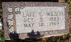
Lafayette Carroll “Lafe” Wilson
| Birth | : | 2 Oct 1883 Atlantic, Cass County, Iowa, USA |
| Death | : | 12 May 1969 Stanton, Stanton County, Nebraska, USA |
| Burial | : | Stanton Cemetery, Stanton, Stanton County, USA |
| Coordinate | : | 41.9599991, -97.2121964 |
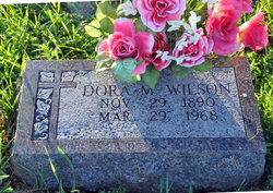
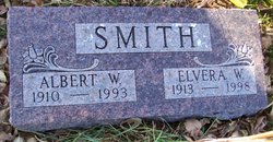
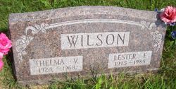
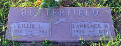
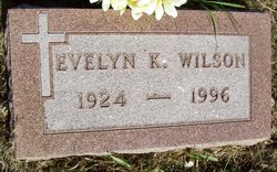
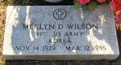
| Description | : | Lafe married Dorothea M. "Dora" Frank on March 28, 1910 in West Point, Nebraska. Lafe and Dora are parents of eight children: 1. Twilda Bernice b. December 29, 1910 d. July 17, 1979 2. Elvera Wilma b. May 26, 1913 d. August 20, 1998 3. Lester Frank b. November 6, 1915 d. January 20, 1985 4. Lillie Laverne b. November 14, 1917 d. July 29, 1982 5. Dorothy Lorene b. June 15, 1920 d. January 12, 1923 6. Evelyn Katherine b. March 24, 1924 d. November 15, 1996 7. Delores Alberta b. March 24, 1925 d. September 18, 1971 8. Merlyn Delbert b. November 14, 1929 d. March 12,... Read More |
frequently asked questions (FAQ):
-
Where is Lafayette Carroll “Lafe” Wilson's memorial?
Lafayette Carroll “Lafe” Wilson's memorial is located at: Stanton Cemetery, Stanton, Stanton County, USA.
-
When did Lafayette Carroll “Lafe” Wilson death?
Lafayette Carroll “Lafe” Wilson death on 12 May 1969 in Stanton, Stanton County, Nebraska, USA
-
Where are the coordinates of the Lafayette Carroll “Lafe” Wilson's memorial?
Latitude: 41.9599991
Longitude: -97.2121964
Family Members:
Parent

Spouse
Siblings
Children
Flowers:


Nearby Cemetories:
1. Stanton Cemetery
Stanton, Stanton County, USA
Coordinate: 41.9599991, -97.2121964
2. Zilmer Cemetery
Stanton, Stanton County, USA
Coordinate: 41.9464000, -97.2528000
3. Belz Cemetery
Stanton, Stanton County, USA
Coordinate: 41.9528008, -97.2619019
4. Koch Cemetery
Stanton County, USA
Coordinate: 41.9855995, -97.1731033
5. Zander Cemetery
Stanton County, USA
Coordinate: 41.9888992, -97.1750031
6. Hoosier Hollow Pioneer Cemetery
Stanton County, USA
Coordinate: 41.9900017, -97.2814026
7. Elkhorn Cemetery
Pilger, Stanton County, USA
Coordinate: 41.9899910, -97.1316720
8. Norwegian Cemetery
Stanton, Stanton County, USA
Coordinate: 41.9171600, -97.2907160
9. Bethlehem Cemetery
Stanton County, USA
Coordinate: 42.0332985, -97.2241974
10. Kuehn Cemetery
Pilger, Stanton County, USA
Coordinate: 41.9682000, -97.1049000
11. Erychleb Cemetery
Stanton County, USA
Coordinate: 41.8664017, -97.2138977
12. Bega Cemetery
Stanton County, USA
Coordinate: 42.0736008, -97.2343979
13. Muller Cemetery
Pilger, Stanton County, USA
Coordinate: 42.0780940, -97.1781920
14. Schwedt Cemetery
Pilger, Stanton County, USA
Coordinate: 41.9240000, -97.0480000
15. Pilger Cemetery
Pilger, Stanton County, USA
Coordinate: 42.0217018, -97.0591965
16. Zion Cemetery
Stanton County, USA
Coordinate: 42.0421982, -97.3638992
17. Christ Lutheran Cemetery
Stanton County, USA
Coordinate: 42.0433006, -97.3636017
18. Norfolk State Hospital New Cemetery
Norfolk, Madison County, USA
Coordinate: 42.0475500, -97.3698300
19. Spring Branch Cemetery
Spring Branch Township, Stanton County, USA
Coordinate: 42.0789400, -97.3297400
20. Saint Matthews Lutheran Cemetery
Wisner, Cuming County, USA
Coordinate: 41.9175000, -97.0189000
21. Norfolk State Hospital Old Cemetery
Norfolk, Madison County, USA
Coordinate: 42.0535400, -97.3733100
22. Pleasant Valley Cemetery
Madison County, USA
Coordinate: 41.8877983, -97.3972015
23. E U B Cemetery
Hoskins, Wayne County, USA
Coordinate: 42.1137900, -97.3015700
24. Trinity Cemetery
Hoskins, Wayne County, USA
Coordinate: 42.1055984, -97.3274994