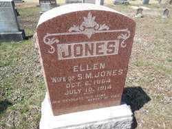
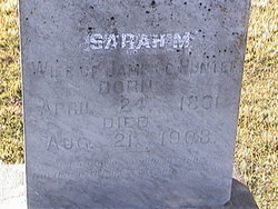
Larcenda Ellen Leslie Jones
| Birth | : | 6 Oct 1864 Cole County, Missouri, USA |
| Death | : | 10 Jul 1914 Russellville, Cole County, Missouri, USA |
| Burial | : | West Cemetery, Somers, Tolland County, USA |
| Coordinate | : | 41.9836006, -72.4606018 |
| Plot | : | Section 1 |
| Inscription | : | Wife of S. M. Jones. How Desolate Our Home Berift of Thee |
frequently asked questions (FAQ):
-
Where is Larcenda Ellen Leslie Jones's memorial?
Larcenda Ellen Leslie Jones's memorial is located at: West Cemetery, Somers, Tolland County, USA.
-
When did Larcenda Ellen Leslie Jones death?
Larcenda Ellen Leslie Jones death on 10 Jul 1914 in Russellville, Cole County, Missouri, USA
-
Where are the coordinates of the Larcenda Ellen Leslie Jones's memorial?
Latitude: 41.9836006
Longitude: -72.4606018
Family Members:
Parent
Spouse
Siblings
Children
Flowers:
Nearby Cemetories:
1. West Cemetery
Somers, Tolland County, USA
Coordinate: 41.9836006, -72.4606018
2. Somers Congregational Church Memorial Garden
Somers, Tolland County, USA
Coordinate: 41.9857190, -72.4461100
3. North Cemetery
Somers, Tolland County, USA
Coordinate: 41.9953003, -72.4492035
4. Center Cemetery
Somers, Tolland County, USA
Coordinate: 41.9890900, -72.4391937
5. Lindy Farms Cemetery
Enfield, Hartford County, USA
Coordinate: 41.9589427, -72.5195122
6. Saint Bernard's Cemetery
Enfield, Hartford County, USA
Coordinate: 41.9930992, -72.5274963
7. Shaker Cemetery
Enfield, Hartford County, USA
Coordinate: 42.0141400, -72.5161600
8. Davis Cemetery
Stafford, Tolland County, USA
Coordinate: 42.0134710, -72.3943690
9. Islamic Center Cemetery
Enfield, Hartford County, USA
Coordinate: 41.9968109, -72.5389862
10. Old Hazardville Cemetery
Hazardville, Hartford County, USA
Coordinate: 41.9867897, -72.5409393
11. New Hazardville Cemetery
Hazardville, Hartford County, USA
Coordinate: 41.9883804, -72.5450592
12. Melrose Cemetery
East Windsor, Hartford County, USA
Coordinate: 41.9372711, -72.5246735
13. Billings Hill Cemetery
East Longmeadow, Hampden County, USA
Coordinate: 42.0433860, -72.5000000
14. Woodworth Cemetery
West Stafford, Tolland County, USA
Coordinate: 41.9732400, -72.3683600
15. Baptist Village Cemetery
East Longmeadow, Hampden County, USA
Coordinate: 42.0559920, -72.4711310
16. Dimick Cemetery
Stafford, Tolland County, USA
Coordinate: 41.9454613, -72.3755493
17. Crystal Lake Cemetery
Stafford, Tolland County, USA
Coordinate: 41.9443626, -72.3759766
18. West Stafford Cemetery
West Stafford, Tolland County, USA
Coordinate: 41.9706612, -72.3601074
19. Old West Stafford Cemetery
West Stafford, Tolland County, USA
Coordinate: 41.9904289, -72.3583679
20. Charter Cemetery
Ellington, Tolland County, USA
Coordinate: 41.9230995, -72.3974991
21. Knesseth Israel Cemetery
Ellington, Tolland County, USA
Coordinate: 41.9073868, -72.4709244
22. New West Stafford Cemetery
West Stafford, Tolland County, USA
Coordinate: 41.9866104, -72.3574371
23. Ellington Center Cemetery
Ellington, Tolland County, USA
Coordinate: 41.9057900, -72.4715540
24. Crystal Lake Center Cemetery
Ellington, Tolland County, USA
Coordinate: 41.9305077, -72.3818970

