
Larry Edward Crane
| Birth | : | 13 Apr 1938 Ottumwa, Wapello County, Iowa, USA |
| Death | : | 15 Sep 1969 Missouri, USA |
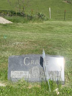
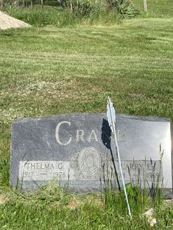
| Burial | : | Wesley Chapel Cemetery, Ash Grove, Davis County, USA |
| Coordinate | : | 40.8643990, -92.5330963 |
| Description | : | Larry Crane of Ottumwa Route 1, was killed Monday evening when a car struck him on U.S. 61 near Perryville, Missouri. Authorities believed he had stopped his truck, owned by Barker Poultry Equipment Company of Ottumwa, to ask the driver of the car behind him to dim his lights. He was struck by a car on the other lane of traffic after he stepped out of his truck. He was the son of Edward J. and Thelma Campbell Crane and attended both Ottumwa and Agency schools. He married Mary Burkhardt on January 5, 1969.... Read More |
frequently asked questions (FAQ):
-
Where is Larry Edward Crane's memorial?
Larry Edward Crane's memorial is located at: Wesley Chapel Cemetery, Ash Grove, Davis County, USA.
-
When did Larry Edward Crane death?
Larry Edward Crane death on 15 Sep 1969 in Missouri, USA
-
Where are the coordinates of the Larry Edward Crane's memorial?
Latitude: 40.8643990
Longitude: -92.5330963
Family Members:
Parent

Flowers:


Nearby Cemetories:
1. Wesley Chapel Cemetery
Ash Grove, Davis County, USA
Coordinate: 40.8643990, -92.5330963
2. Wheeler Cemetery
Davis County, USA
Coordinate: 40.8530000, -92.5378000
3. Baer Cemetery
Davis County, USA
Coordinate: 40.8709984, -92.5100021
4. Mounts Cemetery
Drakesville, Davis County, USA
Coordinate: 40.8530006, -92.5830002
5. Mounds Cemetery
Davis County, USA
Coordinate: 40.8530998, -92.5830994
6. Hopewell Cemetery
Ottumwa, Wapello County, USA
Coordinate: 40.8990000, -92.5590000
7. Breeding Cemetery
Drakesville, Davis County, USA
Coordinate: 40.8302994, -92.4950027
8. Kingsley Cemetery
Blakesburg, Wapello County, USA
Coordinate: 40.9083495, -92.5168542
9. Denton Cemetery
Wapello County, USA
Coordinate: 40.9062000, -92.5633000
10. Adams Cemetery
Marion Township, Davis County, USA
Coordinate: 40.8280890, -92.5776570
11. Glassburner Cemetery
Davis County, USA
Coordinate: 40.8335991, -92.5856018
12. McConnell Cemetery
Drakesville, Davis County, USA
Coordinate: 40.8044440, -92.5294440
13. Hammans Cemetery
Davis County, USA
Coordinate: 40.8059998, -92.5530014
14. Mount Zion Cemetery
Wapello County, USA
Coordinate: 40.9248800, -92.5435300
15. Zion Cemetery
Blakesburg, Wapello County, USA
Coordinate: 40.9250000, -92.5430000
16. Ormanville Cemetery
Ormanville, Wapello County, USA
Coordinate: 40.9136009, -92.4824982
17. Sherman Chapel Cemetery
Davis County, USA
Coordinate: 40.8784000, -92.4515000
18. Bailey Cemetery
Davis County, USA
Coordinate: 40.8810005, -92.6309967
19. Jay Cemetery
Blakesburg, Wapello County, USA
Coordinate: 40.9131012, -92.6108017
20. Harbour Cemetery
Davis County, USA
Coordinate: 40.8314018, -92.4419022
21. West Union Cemetery
Bloomfield, Davis County, USA
Coordinate: 40.7916850, -92.5668560
22. Pleasant Ridge Cemetery
Wapello County, USA
Coordinate: 40.9333000, -92.4856033
23. Drakesville Cemetery
Drakesville, Davis County, USA
Coordinate: 40.7947006, -92.4852982
24. Abegg Cemetery
Wapello County, USA
Coordinate: 40.9194412, -92.6083298