

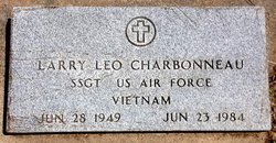
Larry Leo Charbonneau
| Birth | : | 28 Jun 1949 Concordia, Cloud County, Kansas, USA |
| Death | : | 23 Jun 1984 Enid, Garfield County, Oklahoma, USA |
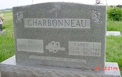
| Burial | : | Ramsey Cemetery, Harrison, Clay County, USA |
| Coordinate | : | 38.4413986, -80.9216995 |
| Inscription | : | SSGT US Air Force Vietnam Wed Oct. 28, 1972 Parents of Larry, Lori and Lance |
| Description | : | The Blade Empire, Concordia, Cloud, Kansas 1 Jul 1984 LARRY CHARBONNEAU Larry L. Charbonneau was born June 28, 1949, in Concordia, Kansas, son of Levi and Dorothy Hubert Charbonnneau. He attended Catholic Grade School; and was a graduated from Notre Dame High School, 1967. He enlisted in the U. S. Air Force in November, 1968, and served in the Vietnam conflict, stationed at Udorn, Thailand. There he maintained the RF4C's aircraft as a Avionics Sensor System Specialist. Following this tour, he also served at Alconbury England; Maxwell AFB, Alabama: Offutt AFB, Nebraska where he completed his career... Read More |
frequently asked questions (FAQ):
-
Where is Larry Leo Charbonneau's memorial?
Larry Leo Charbonneau's memorial is located at: Ramsey Cemetery, Harrison, Clay County, USA.
-
When did Larry Leo Charbonneau death?
Larry Leo Charbonneau death on 23 Jun 1984 in Enid, Garfield County, Oklahoma, USA
-
Where are the coordinates of the Larry Leo Charbonneau's memorial?
Latitude: 38.4413986
Longitude: -80.9216995
Family Members:
Parent
Siblings
Flowers:


Nearby Cemetories:
1. Ramsey Cemetery
Harrison, Clay County, USA
Coordinate: 38.4413986, -80.9216995
2. Asbury Cemetery
Enoch, Clay County, USA
Coordinate: 38.4385480, -80.9361290
3. Fitzwater Cemetery
Enoch, Clay County, USA
Coordinate: 38.4387300, -80.9375800
4. Bailes Cemetery
Enoch, Clay County, USA
Coordinate: 38.4255980, -80.9301990
5. Kyle Cemetery
Clay County, USA
Coordinate: 38.4178009, -80.9341965
6. Acree Cemetery
Nicholas County, USA
Coordinate: 38.4000015, -80.9246979
7. Deal-Dalton Cemetery
Muddlety, Nicholas County, USA
Coordinate: 38.3944410, -80.9206070
8. Gray Cemetery
Harrison, Clay County, USA
Coordinate: 38.5005820, -80.9407320
9. Lilly Fork Cemetery
Clay County, USA
Coordinate: 38.4025290, -80.9965163
10. Adair Cemetery
Clay, Clay County, USA
Coordinate: 38.4565010, -81.0150170
11. Chapman Cemetery
Clay County, USA
Coordinate: 38.5238991, -80.9285965
12. Dilley-Butcher Cemetery
Nicholas County, USA
Coordinate: 38.4987400, -80.8301100
13. Triplett Family Cemetery
Clay, Clay County, USA
Coordinate: 38.4758240, -81.0368280
14. McQueen Cemetery
Muddlety, Nicholas County, USA
Coordinate: 38.3998500, -80.8048300
15. Woods Cemetery - Pisgah Ridge
Clay, Clay County, USA
Coordinate: 38.4187520, -81.0568170
16. McLaughin Cemetery
Duck, Clay County, USA
Coordinate: 38.5499630, -80.9153390
17. Baughman Cemetery
Morris, Nicholas County, USA
Coordinate: 38.4941670, -80.7988890
18. Chapman Cemetery
Ivydale, Clay County, USA
Coordinate: 38.5177800, -81.0270800
19. LeMasters Cemetery
Gilboa, Nicholas County, USA
Coordinate: 38.3272800, -80.9260900
20. McCutchin Cemetery
Nicholas County, USA
Coordinate: 38.3272018, -80.9266968
21. Hill Cemetery
Muddlety, Nicholas County, USA
Coordinate: 38.3932991, -80.7885971
22. Goad Cemetery
Braxton County, USA
Coordinate: 38.5583000, -80.8936005
23. Dundon Cemetery
Clay, Clay County, USA
Coordinate: 38.4647920, -81.0719440
24. Beasley Cemetery
Ivydale, Clay County, USA
Coordinate: 38.5556600, -80.9694700