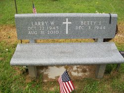
Larry W Robbins
| Birth | : | 22 Oct 1945 Seymour, Jackson County, Indiana, USA |
| Death | : | 31 Aug 2010 Louisville, Jefferson County, Kentucky, USA |
| Burial | : | Hillside Cemetery, Iron Belt, Iron County, USA |
| Coordinate | : | 46.4000015, -90.3377991 |
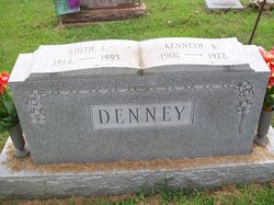
| Description | : | Larry W. Robbins, 64, of Underwood, Indiana died Tuesday, August 31, 2010 at the University Of Louisville Hospital in Louisville, Kentucky. He was born on October 22, 1945 in Seymour, Indiana, the son of the late Kenneth B. and Edith L. (Dean) Denney. Larry was married August 29, 1965 to Betty J. (Brown) Robbins, who survives. He was a retired engine tester for Cummins Engine Company at both Columbus & Seymour Plants for 38 years retiring in 2002 and a member of the New Chapel United Methodist Church in Underwood, Indiana. Survivors in addition to his wife include a daughter:... Read More |
frequently asked questions (FAQ):
-
Where is Larry W Robbins's memorial?
Larry W Robbins's memorial is located at: Hillside Cemetery, Iron Belt, Iron County, USA.
-
When did Larry W Robbins death?
Larry W Robbins death on 31 Aug 2010 in Louisville, Jefferson County, Kentucky, USA
-
Where are the coordinates of the Larry W Robbins's memorial?
Latitude: 46.4000015
Longitude: -90.3377991
Family Members:
Parent
Siblings
Flowers:
Nearby Cemetories:
1. Hillside Cemetery
Iron Belt, Iron County, USA
Coordinate: 46.4000015, -90.3377991
2. Calvary Cemetery
Upson, Iron County, USA
Coordinate: 46.3774986, -90.4080963
3. Greenwood Cemetery
Upson, Iron County, USA
Coordinate: 46.3778000, -90.4094009
4. Sharey Zedek Cemetery
Hurley, Iron County, USA
Coordinate: 46.4433280, -90.1824760
5. Hurley Cemetery
Hurley, Iron County, USA
Coordinate: 46.4429800, -90.1813800
6. Saint Mary's Cemetery
Hurley, Iron County, USA
Coordinate: 46.4443200, -90.1812600
7. Lake View Cemetery
Saxon, Iron County, USA
Coordinate: 46.5010986, -90.4227982
8. Riverside Cemetery
Ironwood, Gogebic County, USA
Coordinate: 46.4599476, -90.1829530
9. Edgewood Cemetery
Gurney, Iron County, USA
Coordinate: 46.4972000, -90.5077972
10. Saint Johns Lutheran Cemetery
Mellen, Ashland County, USA
Coordinate: 46.3923800, -90.5690100
11. Sunset Acres Cemetery
Ironwood, Gogebic County, USA
Coordinate: 46.5189490, -90.1660820
12. Indian Cemetery
Ironwood, Gogebic County, USA
Coordinate: 46.6058330, -90.3305560
13. Hillcrest Cemetery
Bessemer, Gogebic County, USA
Coordinate: 46.4855995, -90.0456009
14. Mellen Union Cemetery
Mellen, Ashland County, USA
Coordinate: 46.3294800, -90.6621800
15. Mount Hope Cemetery
High Bridge, Ashland County, USA
Coordinate: 46.3859700, -90.7353300
16. Lakeside Cemetery
Wakefield, Gogebic County, USA
Coordinate: 46.4674988, -89.9456024
17. Cayuga Union Cemetery
Cayuga, Ashland County, USA
Coordinate: 46.2522011, -90.6802979
18. Greenwood Cemetery
Morse, Ashland County, USA
Coordinate: 46.2224846, -90.6509399
19. Mount Hope Cemetery
Glidden, Ashland County, USA
Coordinate: 46.1431800, -90.5717200
20. Most Precious Blood Cemetery
Glidden, Ashland County, USA
Coordinate: 46.1395226, -90.5726700
21. Mercer Cemetery
Mercer, Iron County, USA
Coordinate: 46.1575012, -90.0539017
22. Bad River Cemetery
Odanah, Ashland County, USA
Coordinate: 46.5992100, -90.7208900
23. Old Apostolic Lutheran Cemetery
Marengo, Ashland County, USA
Coordinate: 46.4408640, -90.8473530
24. Maple Grove Cemetery
Marengo, Ashland County, USA
Coordinate: 46.3852997, -90.8606033


