
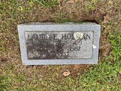
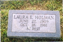
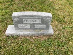
Laura Ellen Oliver Holman
| Birth | : | 27 Jun 1909 Oregon County, Missouri, USA |
| Death | : | 18 Oct 1981 Springfield, Greene County, Missouri, USA |
| Burial | : | Criglersville Cemetery, Criglersville, Madison County, USA |
| Coordinate | : | 38.4634880, -78.3030120 |
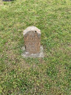
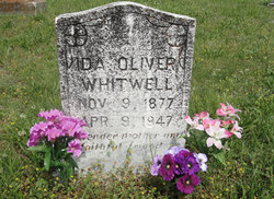
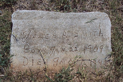
| Description | : | Daughter of William Francis Oliver and Ida Viola (Staggs) Oliver. Married James Smith in 1930. Married 2nd to Al Woolf. Married 3rd to Rolla Holman. |
frequently asked questions (FAQ):
-
Where is Laura Ellen Oliver Holman's memorial?
Laura Ellen Oliver Holman's memorial is located at: Criglersville Cemetery, Criglersville, Madison County, USA.
-
When did Laura Ellen Oliver Holman death?
Laura Ellen Oliver Holman death on 18 Oct 1981 in Springfield, Greene County, Missouri, USA
-
Where are the coordinates of the Laura Ellen Oliver Holman's memorial?
Latitude: 38.4634880
Longitude: -78.3030120
Family Members:
Parent
Spouse
Siblings

Flowers:


Nearby Cemetories:
1. Rosser - Hawkins Cemetery
Criglersville, Madison County, USA
Coordinate: 38.4630290, -78.2998180
2. Gallihugh - Berry Cemetery
Ruth, Madison County, USA
Coordinate: 38.4552994, -78.3146973
3. Mount Zion Baptist Church Cemetery
Syria, Madison County, USA
Coordinate: 38.4744850, -78.3118600
4. Weaver Cemetery
Banco, Madison County, USA
Coordinate: 38.4626550, -78.2793930
5. Oak Grove United Methodist Church Cemetery
Aylor, Madison County, USA
Coordinate: 38.4417580, -78.2998840
6. Brown-Murray-Utz-Leathers Cemetery
Syria, Madison County, USA
Coordinate: 38.4897220, -78.3103090
7. Aylor Family Cemetery
Aylor, Madison County, USA
Coordinate: 38.4358880, -78.3050390
8. Lorenz Gaar Family Cemetery
Aylor, Madison County, USA
Coordinate: 38.4339400, -78.2890200
9. Kite Family Cemetery
Syria, Madison County, USA
Coordinate: 38.4918090, -78.3401920
10. Mount Carmel Baptist Church Cemetery
Haywood, Madison County, USA
Coordinate: 38.4548850, -78.2516670
11. Mount Calvary Baptist Church Cemetery
Haywood, Madison County, USA
Coordinate: 38.4560300, -78.2475490
12. Victory Freewill Baptist Church Cemetery
Madison County, USA
Coordinate: 38.4282990, -78.2660980
13. Yowell Family Cemetery
Etlan, Madison County, USA
Coordinate: 38.5071600, -78.2771400
14. Pleasant Grove Cemetery
Etlan, Madison County, USA
Coordinate: 38.5085050, -78.2738890
15. Tanner Cemetery
Haywood, Madison County, USA
Coordinate: 38.4748260, -78.2395990
16. Goodall Farm Cemetery
Graves Mill, Madison County, USA
Coordinate: 38.4389730, -78.3622600
17. Blankenbaker Burial Ground
Madison, Madison County, USA
Coordinate: 38.4383340, -78.2433640
18. Hoffman Family Cemetery
Madison, Madison County, USA
Coordinate: 38.4047360, -78.2892580
19. Lillard Cemetery
Graves Mill, Madison County, USA
Coordinate: 38.4216420, -78.3581110
20. Rosson Cemetery
Haywood, Madison County, USA
Coordinate: 38.4801690, -78.2260630
21. Kite Family Cemetery
Graves Mill, Madison County, USA
Coordinate: 38.4148370, -78.3555420
22. Jenkins Family Cemetery 2
Stanley, Page County, USA
Coordinate: 38.4719726, -78.2213303
23. Jarrell Cemetery
Graves Mill, Madison County, USA
Coordinate: 38.4110380, -78.3513450
24. Graves Chapel Cemetery
Graves Mill, Madison County, USA
Coordinate: 38.4232290, -78.3707610