

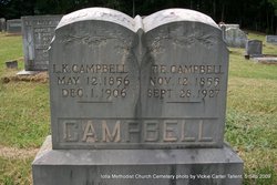
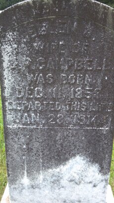
Laura Kansas Bird Campbell
| Birth | : | 12 May 1856 Macon County, North Carolina, USA |
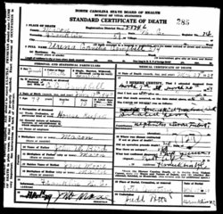
| Death | : | 1 Dec 1906 Macon County, North Carolina, USA |
| Burial | : | Friedhof St. Johann Rapperswil, Rapperswil, Wahlkreis See-Gaster, Switzerland |
| Coordinate | : | 47.2276723, 8.8160435 |
| Description | : | Wife of Thomas Emberton Campbell |
frequently asked questions (FAQ):
-
Where is Laura Kansas Bird Campbell's memorial?
Laura Kansas Bird Campbell's memorial is located at: Friedhof St. Johann Rapperswil, Rapperswil, Wahlkreis See-Gaster, Switzerland.
-
When did Laura Kansas Bird Campbell death?
Laura Kansas Bird Campbell death on 1 Dec 1906 in Macon County, North Carolina, USA
-
Where are the coordinates of the Laura Kansas Bird Campbell's memorial?
Latitude: 47.2276723
Longitude: 8.8160435
Family Members:
Parent
Spouse
Siblings

Children
Flowers:


Nearby Cemetories:
1. Friedhof St. Johann Rapperswil
Rapperswil, Wahlkreis See-Gaster, Switzerland
Coordinate: 47.2276723, 8.8160435
2. Polenmuseum Rapperswil SG
Rapperswil, Wahlkreis See-Gaster, Switzerland
Coordinate: 47.2272566, 8.8154879
3. Pfarrkirche St. Peter und Paul und Martinskapelle
Ufenau, Bezirk Höfe, Switzerland
Coordinate: 47.2179300, 8.7788100
4. Friedhof Rüti
Rüti, Bezirk Hinwil, Switzerland
Coordinate: 47.2555900, 8.8494300
5. Friedhof Bubikon
Bubikon, Bezirk Hinwil, Switzerland
Coordinate: 47.2696293, 8.8173232
6. Friedhof Hombrechtikon
Hombrechtikon, Bezirk Meilen, Switzerland
Coordinate: 47.2526200, 8.7638100
7. Friedhof Dürnten
Dürnten, Bezirk Hinwil, Switzerland
Coordinate: 47.2787764, 8.8477695
8. Friedhof Kirchbühl Stäfa
Stäfa, Bezirk Meilen, Switzerland
Coordinate: 47.2395500, 8.7323100
9. Friedhof Grüningen
Grüningen (Stedtli), Bezirk Hinwil, Switzerland
Coordinate: 47.2832586, 8.7650566
10. Friedhof Richterswil
Richterswil, Bezirk Horgen, Switzerland
Coordinate: 47.2081700, 8.7023700
11. Waldfriedhof Gossau ZH
Gossau, Bezirk Hinwil, Switzerland
Coordinate: 47.3042906, 8.7726030
12. Friedhof Männedorf
Mannedorf, Bezirk Meilen, Switzerland
Coordinate: 47.2555500, 8.6973600
13. Friedhof Schindellegi
Schindellegi, Bezirk Höfe, Switzerland
Coordinate: 47.1744200, 8.7132600
14. Friedhof Wädenswil
Wadenswil, Bezirk Horgen, Switzerland
Coordinate: 47.2206900, 8.6751000
15. Friedhof Wetzikon
Wetzikon, Bezirk Hinwil, Switzerland
Coordinate: 47.3271600, 8.8121200
16. Friedhof der Abteikirche Einsiedeln
Einsiedeln, Bezirk Einsiedeln, Switzerland
Coordinate: 47.1294500, 8.7578300
17. Gemeinde Friedhof Egg
Egg, Bezirk Uster, Switzerland
Coordinate: 47.2965779, 8.6932955
18. Friedhof Räbacher
Mönchaltorf, Bezirk Uster, Switzerland
Coordinate: 47.3153500, 8.7220900
19. Friedhof Seegräben
Seegraben, Bezirk Hinwil, Switzerland
Coordinate: 47.3430353, 8.7732897
20. Friedhof Meilen
Meilen, Bezirk Meilen, Switzerland
Coordinate: 47.2715700, 8.6391100
21. Friedhof Uster
Uster, Bezirk Uster, Switzerland
Coordinate: 47.3449300, 8.7135900
22. Friedhof Hirzel
Hirzel-Kirche, Bezirk Horgen, Switzerland
Coordinate: 47.2154500, 8.6069700
23. Friedhof Bauma
Bauma, Bezirk Pfäffikon, Switzerland
Coordinate: 47.3661933, 8.8777230
24. Friedhof Humrigen
Herrliberg, Bezirk Meilen, Switzerland
Coordinate: 47.2846540, 8.6191287